16 Places on Earth That Expand and Shrink Depending on the Season
Seasons change and Earth changes in amazing ways. Some landscapes drastically change in scale, look, and even accessibility all year long. These dynamic environments expand and contract in response to changing temperatures, rainfall patterns, and other seasonal factors – creating their own rhythmic cycle of growth and retreat.
Depending on timing, such natural events provide very diverse experiences for guests; occasionally, they make sites absolutely unrecognizable from one season to the next. Here is a list of 16 amazing sites on Earth that physically expand and decrease with the seasons, therefore highlighting the great adaptation of nature to our planet’s periodic cycles.
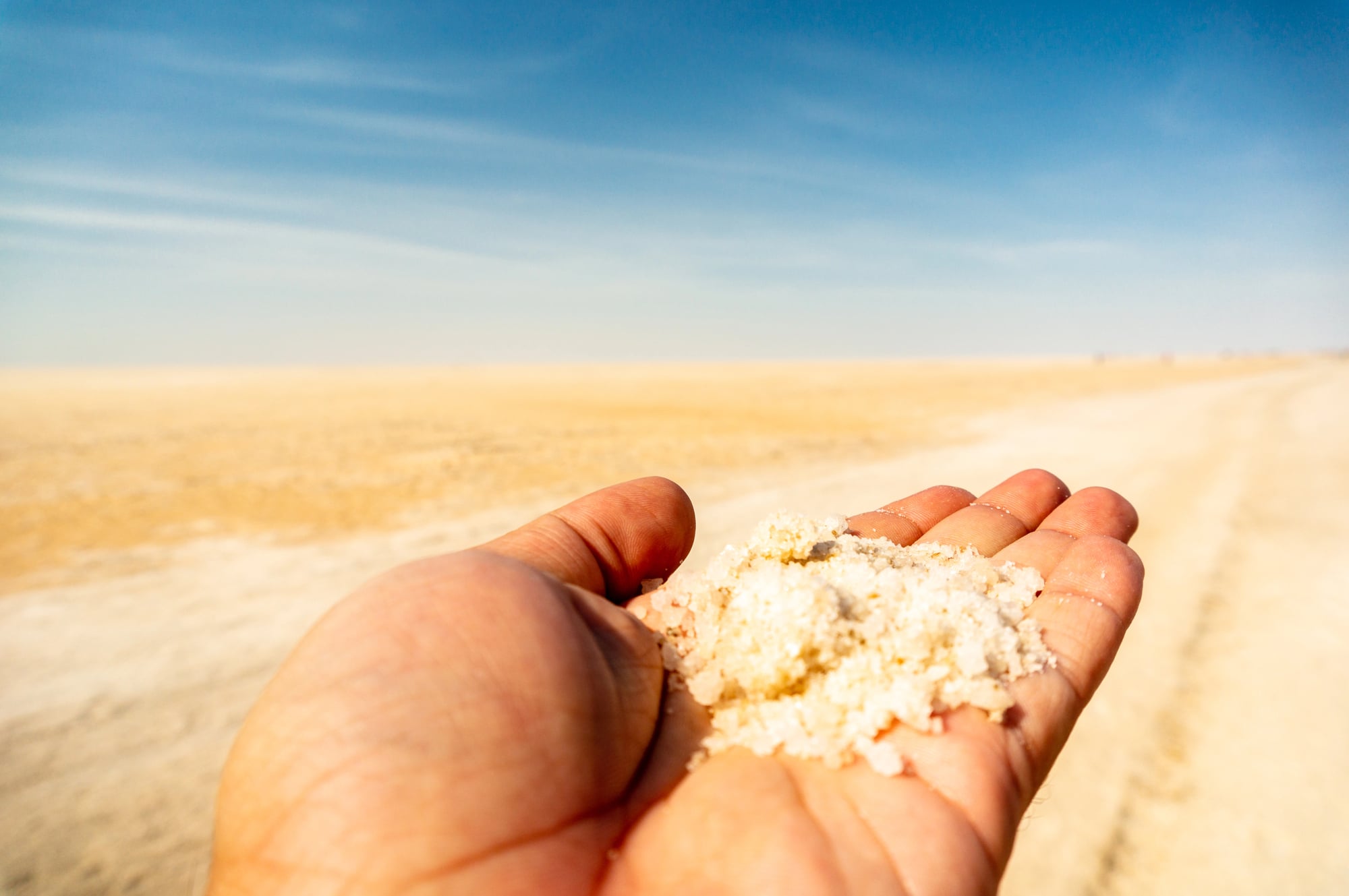
Salar de Uyuni
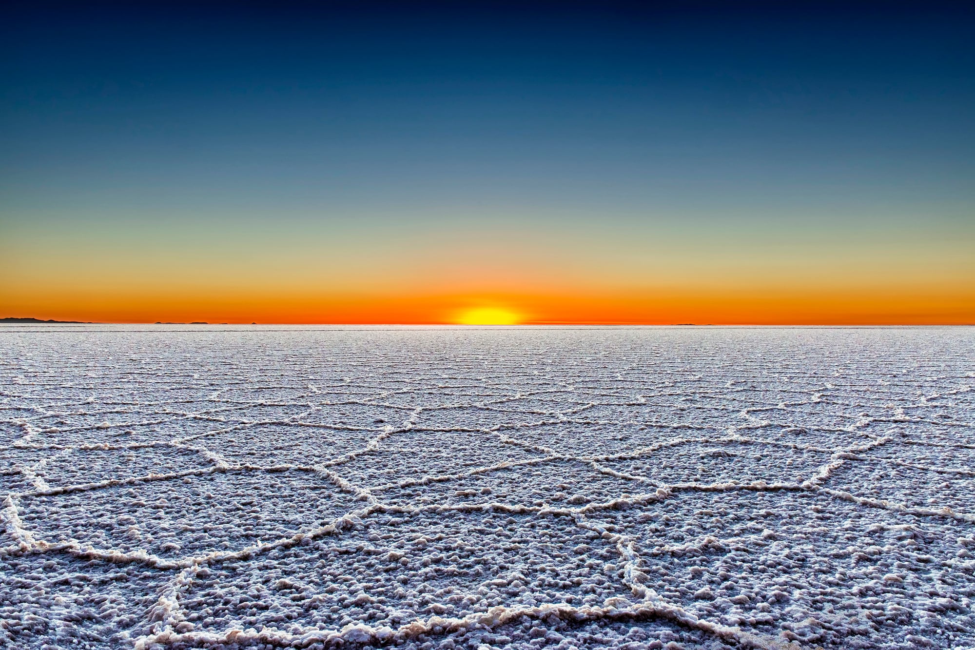
Bolivia’s Salar de Uyuni presents itself as the world’s largest salt flat during dry months – a vast, cracked expanse of brilliant white stretching over 4,000 square miles. The rainy season transforms this same landscape into an enormous, perfectly reflective mirror where sky and earth merge into a surreal panorama that’s disorienting yet mesmerizing.
Just a few inches of seasonal water atop the salt crust completely alters both the environment’s appearance and the experience of being there, though the chemical composition remains unchanged beneath the surface.
Okavango Delta
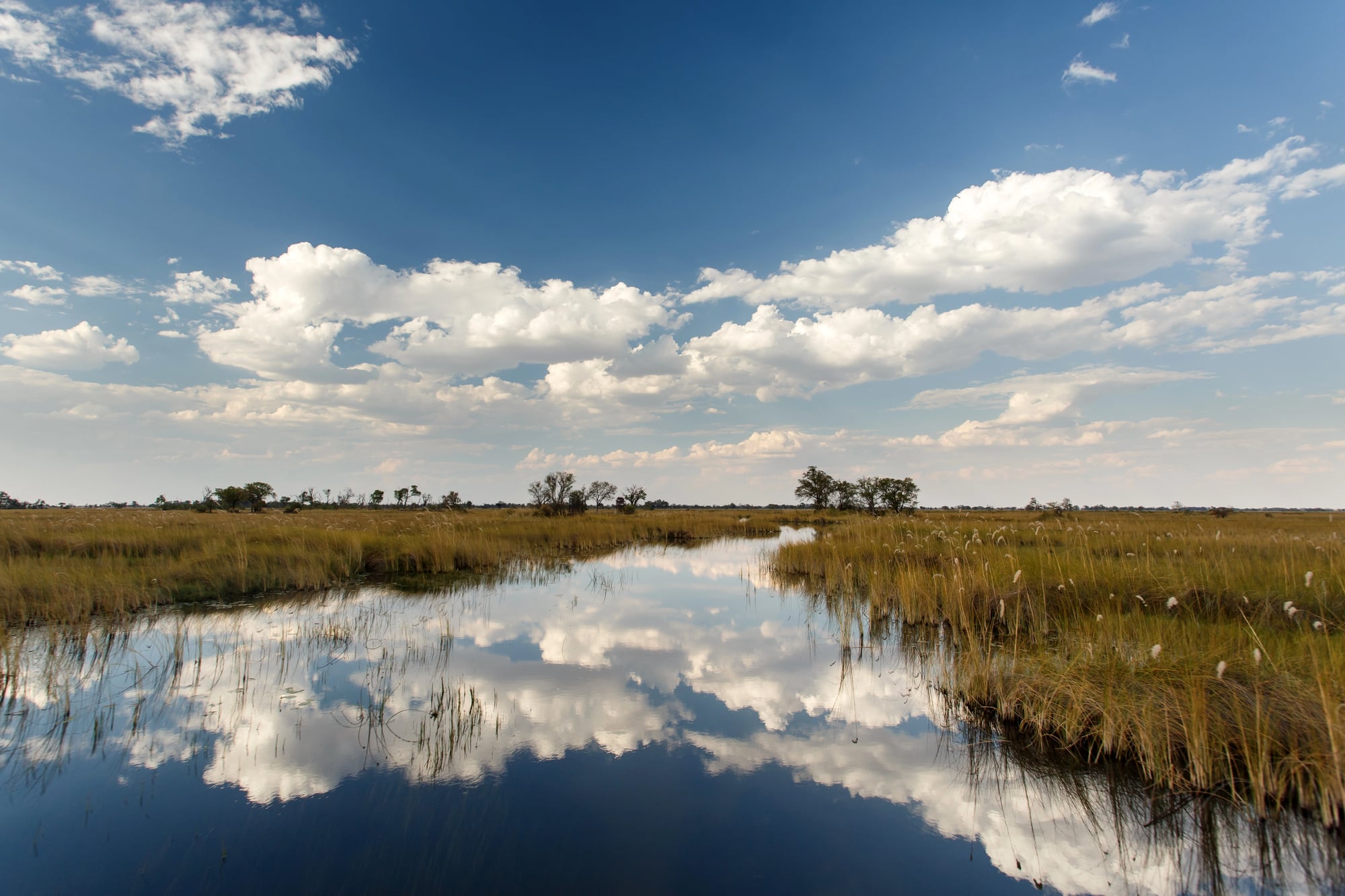
This remarkable inland river delta in Botswana fluctuates dramatically between seasons, expanding from roughly 2,300 square miles in dry months to over 5,800 square miles during annual floods. Seasonal waters travel over 1,000 miles from highlands in Angola – arriving months after the actual rainfall occurs elsewhere.
Wildlife migrate hundreds of miles to reach these life-sustaining seasonal wetlands, transforming the ecosystem’s population density and biodiversity as the delta pulses between states of abundance and scarcity.
Lake Cerknica
Slovenia houses one of Europe’s largest intermittent lakes – a remarkable vanishing body of water occupying a karst polje (that’s a large depression with numerous underground drainage channels). During spring snowmelt and heavy rainfall, the basin floods to create a lake covering nearly 10 square miles.
By summer, over sixty underground sinkholes – locally called ponors – completely drain the water away, leaving meadows where farmers graze livestock. This hydrological cycle has occurred predictably for millennia, creating a unique ecosystem adapted to guaranteed impermanence.
Badwater Basin

The famed salt flats of Death Valley change momentarily following unusual precipitation events. Usually sun-baked, polygon-cracked surface, resting 282 feet below sea level, it momentarily forms a shallow lake over the valley floor.
Although these ephemeral rivers hardly linger in the intense desert heat, their fleeting existence produces breathtaking mountain reflections that photographers pursue fervently. Often more noticeable following each wetening cycle, evaporation reclaims the moisture gradually re-establishing the unique hexagonal salt patterns.
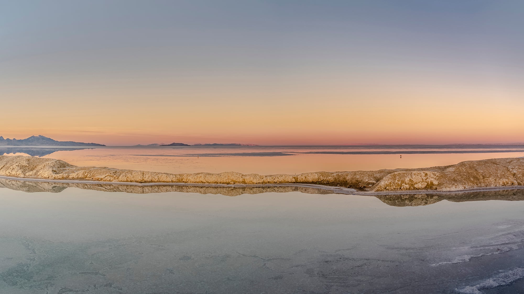
Bonneville Salt Flats

Utah’s vast white expanse spends part of each year underwater – dramatically altering both its appearance and accessibility with seasonal precipitation. Winter rainfall creates a shallow, mineral-rich lake atop the ancient salt pan, sometimes persisting through spring before summer heat wins the evaporation battle.
The smooth, hard surface that emerges afterward has made this location famous for land speed records. This annual drowning and drying continually rebuilds the salt crust by dissolving, mixing, and redepositing minerals through natural processes that engineers struggle to replicate.
Makgadikgadi Pans

Botswana’s massive salt pans remain bone-dry most of the year – creating a harsh, nearly lifeless landscape of cracked clay and salt deposits across 6,200 square miles. Seasonal rains transform this same area into a network of shallow lakes that attract thousands of flamingos and other water birds seemingly overnight.
Local zebra and wildebeest populations trek long distances to access these temporary waters, creating one of Africa’s lesser-known yet impressive wildlife migrations. The ephemeral wetlands support brief but intense bursts of life before surrendering again to dusty desolation.
Danakil Depression

Ethiopia’s geological wonder displays dramatic seasonal variations in one of Earth’s most extreme environments. During dry periods, this below-sea-level desert showcases alien-like mineral formations, vast salt plains, and acidic hot springs in psychedelic colors.
Seasonal flooding temporarily inundates portions of the depression – altering access routes and sometimes completely submerging certain features beneath shallow waters. The fluctuating moisture levels continuously reshape the mineral deposits and salt formations, making each visit potentially unique even for returning travelers.
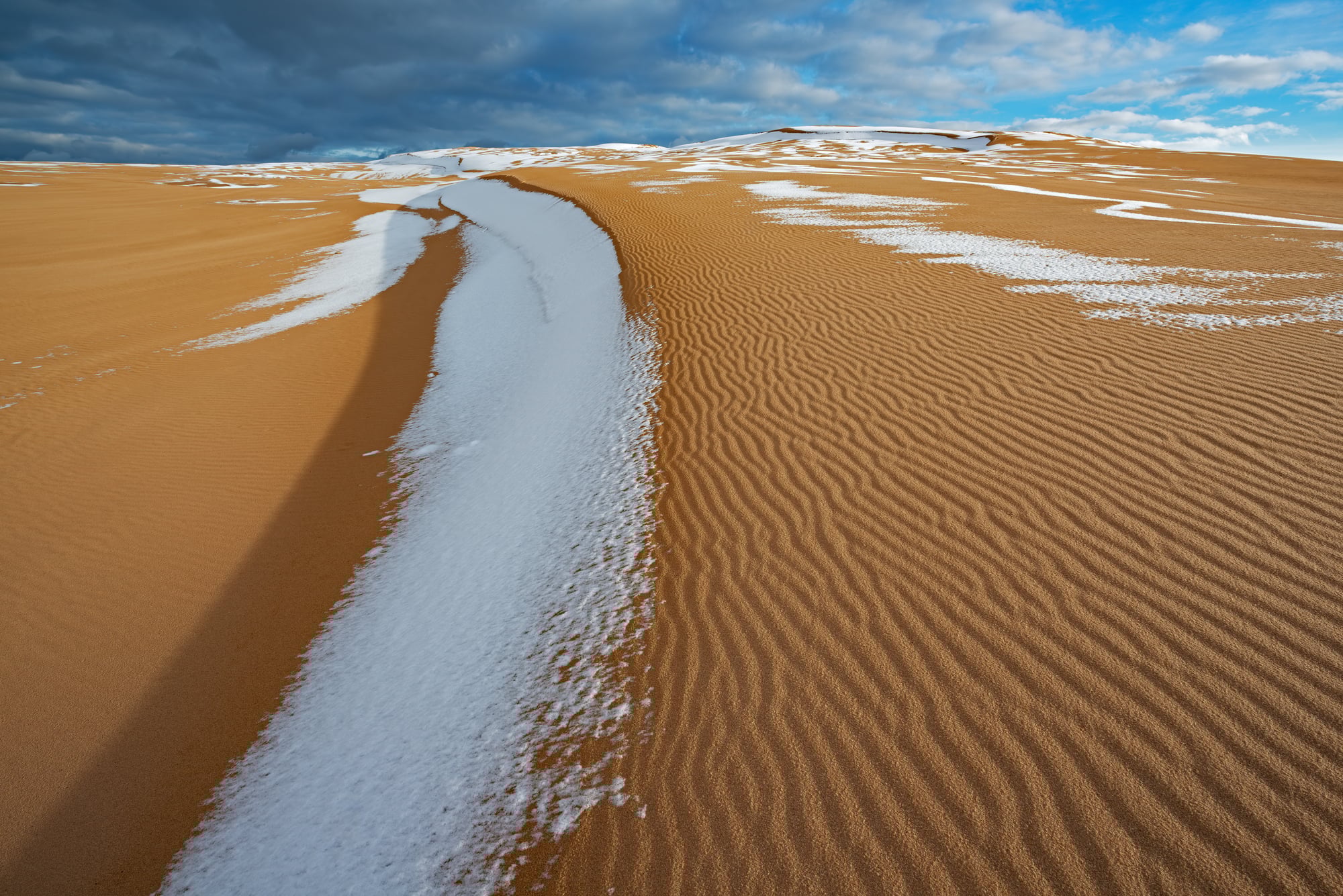
Lençóis Maranhenses

Brazil houses this unusual ecosystem featuring massive white sand dunes that fill with thousands of crystal-clear rainwater lagoons during wet months. Between January and June, rainfall collects in the valleys between towering dunes – creating blue-green pools reaching depths up to 10 feet despite the seemingly inhospitable surroundings.
These temporary lagoons vanish completely during the dry season, returning the landscape to an endless sea of undulating sand. Remarkably, some fish species survive in these ephemeral waters by burying eggs that remain dormant until the next year’s rains.
Lake Chilika
India’s largest coastal lagoon expands from approximately 400 square miles during dry season to over 680 square miles during monsoons – an increase larger than New York City’s entire area. This dramatic size fluctuation creates constantly shifting habitats for the lake’s diverse wildlife, including rare Irrawaddy dolphins that adjust their territories accordingly.
Seasonal river discharges battle ocean tides in this brackish ecosystem, altering water salinity levels and depth throughout the year. Local fishing communities have adapted their techniques and territories over generations as the lake’s boundaries expand and contract predictably.
Kakadu Wetlands
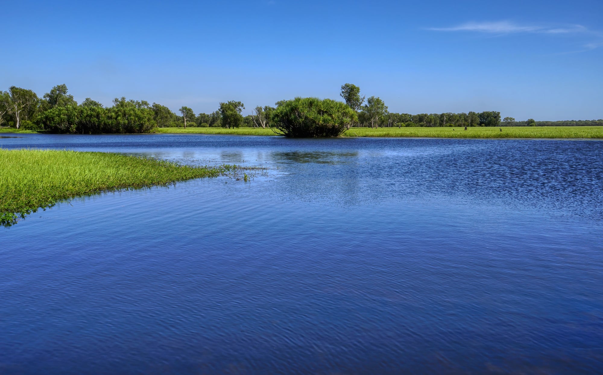
Australia’s largest national park undergoes such dramatic seasonal changes that Aboriginal traditional owners recognize six distinct seasons rather than four. During the wet season, floodplains expand across vast areas – connecting rivers and billabongs into what essentially becomes an inland sea.
The subsequent dry season gradually contracts these waters into isolated pools teeming with concentrated wildlife. This continuous cycle of expansion and contraction hasn’t just shaped the landscape but has deeply influenced indigenous cultural practices and ecological knowledge for over 65,000 years of continuous habitation.
Rann of Kutch

This massive seasonal salt marsh in western India transitions between completely different states with changing monsoon patterns. During summer months, it becomes a vast, arid salt desert stretching across thousands of square miles.
Monsoon rains combined with seawater inundation transform the same area into a shallow wetland – temporarily connecting what was barren desert to the Arabian Sea. The constantly shifting boundaries between land and water have made this region particularly challenging to map accurately, with satellite imagery from different months showing drastically different coastlines.
Etosha Pan

Namibia’s massive salt flat remains dry and dusty most years, covering approximately 1,800 square miles of cracked white clay. Occasional seasonal rains flood portions of the pan, creating a shallow lake that dramatically alters wildlife distribution throughout the national park as animals congregate around the temporary water source.
Even brief flooding events trigger remarkable biological responses – dormant eggs hatch and seemingly dead plants spring to life within days. The shimmering heat mirages visible during dry periods occasionally give way to actual standing water that reflects the African sky with perfect clarity.
Playa Lakes

The southwestern United States features countless ephemeral lakes that appear and disappear with seasonal precipitation patterns. During dry periods, these basins present as flat, sometimes cracked claypans with distinctive vegetation rings marking their maximum water levels.
Heavy rainfall can fill these depressions within hours, creating temporary lakes that might last days or months depending on subsequent weather conditions. Their unpredictable nature creates boom-and-bust cycles for specialized plant and animal communities that have evolved remarkable adaptations to these extreme environmental fluctuations.
Silver Lake Sand Dunes
Michigan’s coastal dunes undergo continuous transformation between seasons as wind patterns, vegetation growth, and lake levels fluctuate throughout the year. Winter storms and high water levels often erode significant portions of the dunes, while summer conditions allow new sand accumulation and dune-building processes to resume.
Spring brings periods of both extreme mobility and temporary stabilization as pioneering plants attempt to colonize the shifting sands before being buried or exposed. This constant cycle creates a dynamic ecosystem that never maintains exactly the same shape from one year to the next.
Great Rann Salt Desert
This seasonal salt marsh in India covers over 10,000 square miles, transforming from a vast, flat desert during dry months to a shallow inland sea during monsoon season. The annual flooding comes from both local rainfall and seawater intrusion through tidal creeks connecting to the Arabian Sea.
As waters recede, they leave behind fresh mineral deposits that maintain the flat, white surface making this landscape so distinctive. Local communities have adapted their entire way of life to this predictable expansion and contraction, with traditional housing built on elevated platforms to withstand seasonal floods.
Antarctica’s Sea Ice
The frozen continent experiences the world’s most dramatic seasonal expansion and contraction of surface area. During winter, sea ice extends outward from Antarctica by approximately 7.3 million square miles – effectively doubling the continent’s size and creating an ice platform larger than Russia.
Summer brings rapid melting that shrinks this ice sheet back toward the permanent landmass. This cycle creates vastly different conditions for wildlife, scientific research activities, and shipping access throughout the year. Climate change continues altering this historical pattern in concerning ways, with increasingly unpredictable implications for global ocean currents and weather patterns.
Nature’s Breathing Spaces
These remarkable landscapes remind us that our planet isn’t static – it’s constantly in flux, with boundaries between land and water remaining under perpetual negotiation. The seasonal transformations reflect complex interactions between global weather patterns, local geography, and biological adaptations that have evolved over countless generations.
Communities near these transitional zones have developed fascinating strategies for thriving amidst such predictable unpredictability. There’s something profound about places that refuse to remain fixed, expanding and contracting with Earth’s natural rhythms. As climate patterns shift worldwide, these seasonally transformed landscapes may offer crucial lessons about resilience and adaptation in changing environments. They’re essentially nature’s masterclass in embracing impermanence rather than fighting against it.
More from Go2Tutors!

- The Romanov Crown Jewels and Their Tragic Fate
- 13 Historical Mysteries That Science Still Can’t Solve
- Famous Hoaxes That Fooled the World for Years
- 15 Child Stars with Tragic Adult Lives
- 16 Famous Jewelry Pieces in History
Like Go2Tutors’s content? Follow us on MSN.