Cities With More Canals Than Venice
Venice gets all the attention when people think about canal cities. The gondolas, the bridges, the romance of floating down ancient waterways — it’s become the standard everyone else gets measured against.
And Venice deserves the recognition. But here’s something that catches most people off guard: dozens of cities around the world have more canals than Venice does. Venice has about 26 miles of canals.
That’s impressive until you start looking at what other places have built. Some cities dwarf Venice by ten times or more.
The reasons vary. Some needed flood control, others used waterways for industrial transport, and a few were just built that way from the start.
Cape Coral Holds the World Record
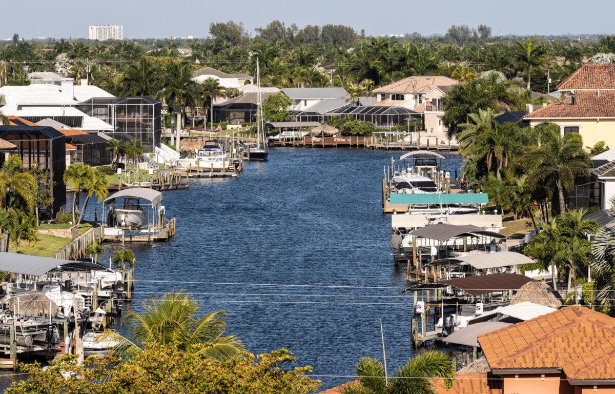
Cape Coral in Florida sits at the top of the list with over 400 miles of navigable canals. The city was planned in the 1950s by two brothers from Baltimore who bought a massive tract of land and carved it up with waterways.
Today the system mixes freshwater and saltwater canals, with about half providing access to the Gulf of Mexico. Nearly 40,000 lots in Cape Coral sit on waterfront property.
You can live in a regular suburban neighborhood and still dock a boat behind your house. The city sprawls across 120 square miles, and water defines how it works.
Residents use the canals for recreation, property values stay high because of water access, and the system handles stormwater drainage. The development came at a cost.
The canals changed local ecology and tides. Wildlife had to adapt.
But the city continues to attract people who want that waterfront lifestyle without the price tag of oceanfront property in other Florida locations.
Birmingham Has Industrial Roots
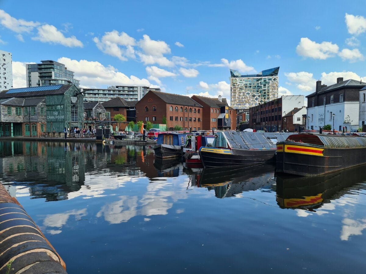
Birmingham in England surprises people. This city in the Midlands, known for factories and heavy industry, has somewhere between 100 and 114 miles of canals.
That beats Venice by a wide margin. The canals date back to the Industrial Revolution.
Factories needed coal, iron, and raw materials. Roads couldn’t handle the volume. So engineers built waterways to move everything by barge.
The system grew to about 170 miles at its peak in the 1700s and 1800s. Many of the canals fell into disrepair as trucks and trains took over transport duties.
Parts of the system became dumping grounds. But Birmingham has spent decades cleaning them up.
Now the city center has bars, restaurants, and apartments along the water. Gas Street Basin shows what the canals look like when they’re maintained.
The canals weren’t built for beauty. They were practical infrastructure.
But they’ve aged into something worth preserving.
Alappuzha Covers Southern India

Alappuzha, also called Alleppey, has more than 900 miles of canals threading through the region. The city sits in Kerala on India’s southwest coast, where rivers and backwaters create a natural maze of waterways.
Locals added canals to connect everything. The system mixes natural and manmade. Six main rivers feed into it.
Forty-four smaller rivers branch off. Twelve islands dot the area.
The elevation stays low — about three feet above sea level — which makes flooding common but also creates ideal conditions for growing crops below sea level. Tourism centers on houseboat rentals.
Over 1,000 houseboats operate in the area. You can cruise for days and see paddy fields, fishing villages, and coconut groves.
The water stays calm. Life moves slower here than in most cities.
The canals originally transported coir, the fiber from coconut husks. Commercial traffic has mostly stopped, but the waterways remain the easiest way to get around certain areas.
Some villages can only be reached by boat.
Hamburg Claims the Most Bridges
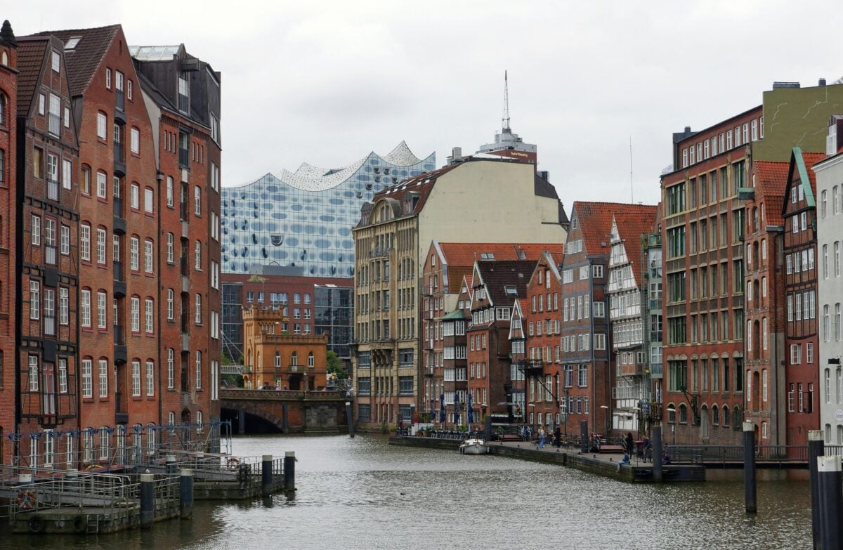
Hamburg in Germany has more bridges than Venice, Amsterdam, and London combined. The exact count sits around 2,500 bridges crossing streams, rivers, and canals throughout the city.
Venice only has about 400 bridges for comparison. The Alster and Elbe rivers form the backbone of Hamburg’s water system.
Canals branch off from there. The Speicherstadt district, a warehouse area built on canals, earned UNESCO World Heritage status.
The red brick buildings with copper turrets create a distinctive look. Hamburg’s waterways were never about sightseeing.
This is Germany’s largest port and Europe’s third-largest after Rotterdam and Antwerp. The canals moved goods during Hamburg’s days as a Hanseatic League city.
They still serve commercial purposes today, though tourism has become part of the mix. The water gives Hamburg its character.
The city doesn’t sit on one major river like most European cities. Instead it wraps around water on all sides.
Amsterdam Built Rings of Water
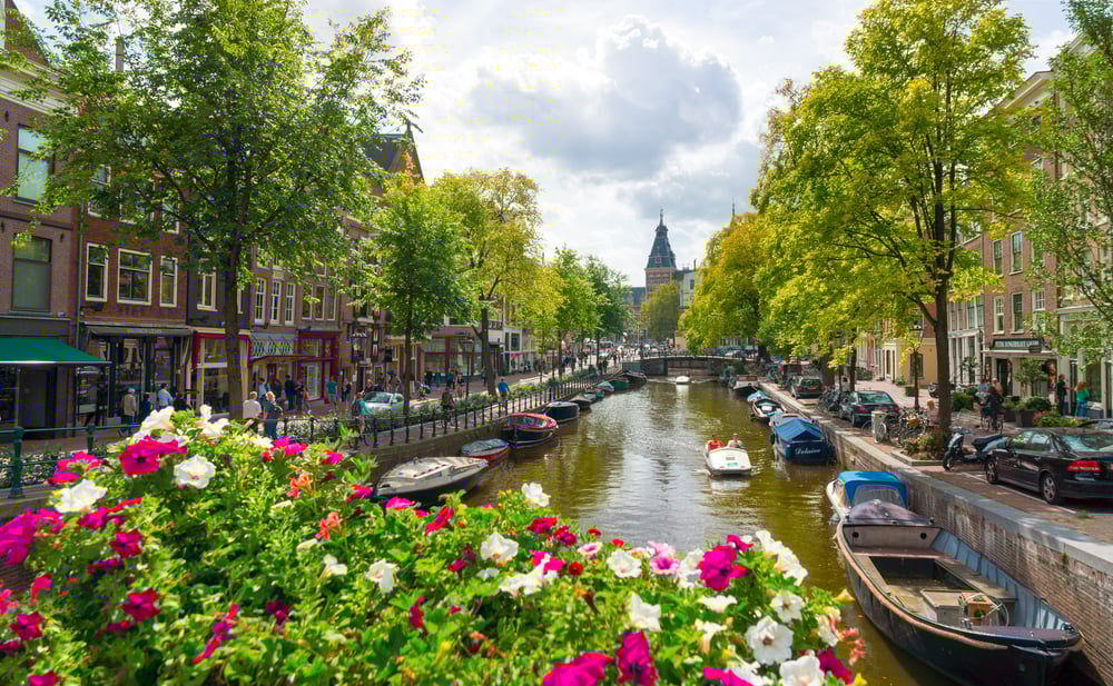
Amsterdam has more than 60 miles of canals arranged in distinctive concentric rings around the old city center. Three main canals — Herengracht, Prinsengracht, and Keizersgracht — were built during the Dutch Golden Age in the 1600s.
The design was supposed to be perfectly circular, but money ran out before completion. The imperfect rings became what we see today.
UNESCO listed the canal ring as a World Heritage site, and more than 1,550 monuments and museums border the waterways. The canals hold a quarter of Amsterdam’s surface area.
Over 1,000 bridges connect the city. Houseboats line the water, and bike paths run alongside most canals.
The system manages drainage while creating the layout that makes Amsterdam instantly recognizable. Unlike some cities where canals were purely functional, Amsterdam’s waterways were always part of urban planning.
The rich built mansions along the main canals. Workers lived on the smaller side canals.
The water organized society.
St. Petersburg Connects Islands

St. Petersburg in Russia has about 60 canals totaling more than 180 miles of waterways. The city was built on marshland in the Neva River delta, and water surrounds everything.
Peter the Great founded the city in the early 1700s. He wanted a new capital that could compete with European cities.
Engineers dug canals to drain the swamps and connect navigable rivers. The result turned St. Petersburg into a complex of about 40 islands.
The canals pass major landmarks. The State Hermitage Museum sits on the water.
So do stunning cathedrals and mansions from the imperial era. More than 500 bridges cross the waterways, many designed as architectural showpieces.
The bridges rise on scheduled nights between April and November to let ships pass underneath. During “White Nights” in late June when darkness never fully arrives, watching the bridges lift has become a ritual.
Suzhou Shows Ancient China

Suzhou in China earned the nickname “Venice of the East” for good reason. About 15 canals run through the historic district, some dating back to the 5th century BC.
The canals connect to the Grand Canal, which stretches 1,200 miles and ranks as the world’s longest artificial waterway. The city sits in the Yangtze Delta. Classical gardens line the canals — many are UNESCO World Heritage sites.
Old houses with white walls and black roofs lean over the water. Stone bridges arch across narrow channels.
Suzhou gives you a glimpse of what China looked like before modern development took over. The historic district has strict building codes.
No skyscrapers can go up. The government protects the area to preserve the traditional layout.
Boat tours take you past pagodas and into garden complexes where wealthy merchants once lived. The canals were always about more than transport.
They shaped how the city developed over centuries.
Bangkok Has the Biggest System

Bangkok claims the largest canal network in the world, though exact measurements get murky. The Chao Phraya River splits into nine major canals that flow through the city.
Two more rivers — Mae Klong and Tha Chin — join the system and extend throughout Thailand. The canals host floating markets where vendors sell produce, cooked food, and handicrafts from boats.
Shoppers pull up in their own boats. The markets draw heavy tourist traffic, but locals still use them.
Bangkok’s canal system isn’t pretty everywhere. Many waterways in the Thonburi neighborhood and outlying areas have deteriorated.
The water can smell bad. Old houses tilt at odd angles along the banks. But fishermen still work the canals daily, and some communities rely on boats as the main form of transport.
The city drained many canals over the years due to cholera risk and to make room for roads. What remains shows how Bangkok functioned before cars dominated.
The canals were the original infrastructure.
Amiens Features Floating Gardens

Amiens in northern France has about 25 miles of canals spreading across 300 hectares of marshland. The city sits on the Somme River, and the Saint-Leu quarter features colorful houses accessed by bridges.
Medieval workers harvested peat around Amiens. That left shallow channels which turned into canals over time.
The area called Les Hortillonnages became floating gardens. Traditional flat-bottomed barges navigate the narrow waterways between garden plots.
You can tour the floating gardens from boats. The canals pass within sight of the largest Gothic cathedral in France.
Old buildings crowd the water in the city center. The whole setup feels compact compared to sprawling modern canal cities.
Amiens never developed the same tourist profile as Bruges or Amsterdam. But the canals create the same essential atmosphere — water shaping how a city looks and functions.
Fort Lauderdale Stretches for Miles

Fort Lauderdale in Florida sits on the Intracoastal Waterway, a 3,000-mile network of bays, inlets, sounds, and canals running along the Atlantic and Gulf coasts. The city itself has about 165 miles of navigable waterways.
Canals branch through residential neighborhoods. Boats replace cars as the primary way some people get around.
Waterfront restaurants and marinas line the channels. The system connects to the ocean, so saltwater flows through most of the canals.
Fort Lauderdale built its identity around boats and water access. The annual boat show draws hundreds of thousands of visitors.
Yacht sales happen here. The canals enable a lifestyle centered on being on or near the water.
The waterways also serve practical purposes. Florida needs drainage.
All those canals help manage stormwater during the state’s intense rainy season. Without them, flooding would be constant.
Stockholm Spreads Across Islands

Stockholm sits on 14 islands where Lake Mälaren meets the Baltic Sea. Canals and waterways connect everything.
The old town had the nickname “The Town Between the Bridges” before it became Gamla Stan. About 50 bridges cross Stockholm’s waterways.
The Göta Canal system connects Stockholm to Gothenburg on the west coast. That canal has 58 locks and 47 bridges along its route.
Stockholm uses its water for beauty and function. Ferries transport people across the city.
Boat tours show off palaces and government buildings. The water stays clean enough for people to swim in certain areas during summer.
The city grew around the water rather than despite it. Each island developed its own character.
Some house museums and tourist sites. Others are residential.
The canals create natural divisions.
Copenhagen Centers on Nyhavn
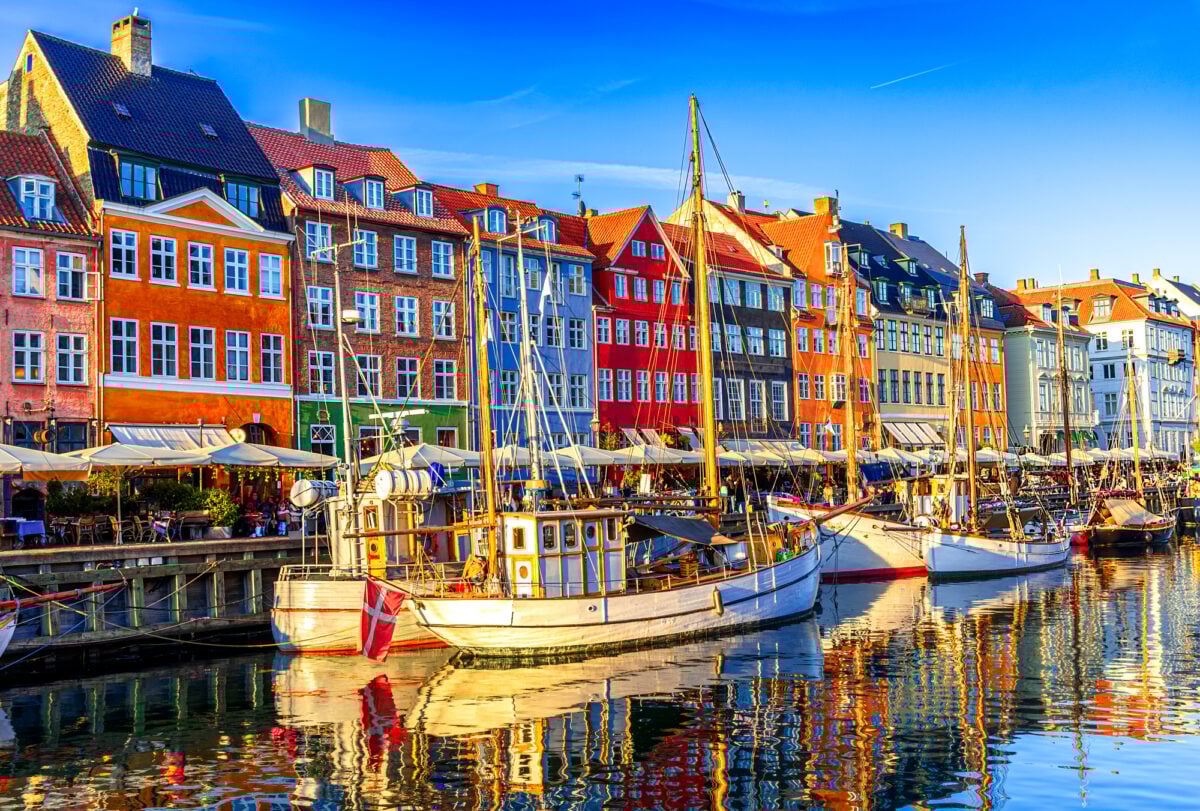
Copenhagen’s canals center on the Nyhavn district. This 17th-century waterfront area has brightly colored townhouses and old wooden ships docked along the water.
The canals spread from there throughout the city. Nyhavn works as a gathering place.
Cafes and restaurants fill the ground floors of those colorful buildings. People sit outside when weather permits.
The canal hosts boat tours that show off Copenhagen’s landmarks. Copenhagen doesn’t have the extensive canal network of some other European cities.
But the canals do get used constantly. The city embraces its waterfront rather than turning its back on it.
Danish cities generally treat water as an amenity. Canals mean pleasant places to walk, spots to eat outside, and scenic routes for tourists.
Bruges Preserved Medieval Charm

Bruges in Belgium probably doesn’t have more total canal length than Venice, but the comparison comes up constantly. The canals here date back to the 12th century when Bruges operated as a major commercial port.
The city arranged its canals in an oval frame around the medieval center. Boat tours follow this route past old merchants’ houses, churches, and the famous Rozenhoedkaai spot where everyone stops for photos.
Bruges faced the same overtourism problems as Venice. Too many visitors crowded the narrow streets and canal boats.
The city now limits cruise ship arrivals and promotes visits during off-peak times. The canals made Bruges wealthy during the Middle Ages.
Ships brought goods from across Europe. That wealth paid for the buildings that attract tourists today.
The water created the city’s fortune and its lasting appeal.
Where Water Shapes Cities

Venice set the template. Canals as a romantic backdrop, as tourist attraction, as defining features. But Venice never had a monopoly on waterways running through city streets.
Places like Cape Coral and Birmingham built their canals for practical reasons — drainage, transport, development. The romance came later if it came at all.
Other cities like Suzhou and St. Petersburg incorporated canals into urban design from the beginning. The canals that work best today serve multiple purposes.
They move people and goods. They provide recreation.
They handle stormwater. They create property value.
Single-purpose canals tend to decay when their original function becomes obsolete. These cities prove that water can organize urban life in countless ways.
Sometimes it’s about engineering. Sometimes it’s about preserving history.
Sometimes it’s just about making a place more livable by adding blue spaces between the buildings. The canal cities that thrive are the ones that keep finding new uses for old waterways.
More from Go2Tutors!

- The Romanov Crown Jewels and Their Tragic Fate
- 13 Historical Mysteries That Science Still Can’t Solve
- Famous Hoaxes That Fooled the World for Years
- 15 Child Stars with Tragic Adult Lives
- 16 Famous Jewelry Pieces in History
Like Go2Tutors’s content? Follow us on MSN.