Photos Of the Most Dangerous Hiking Trails in the World
There’s a particular kind of hiker who looks at a perfectly good, well-marked trail and thinks: not enough. They want exposure, altitude, crumbling rock faces, paths that barely qualify as paths.
And the world, it turns out, has no shortage of places willing to oblige.
Some of these trails are dangerous because of sheer vertical drops. Others because of weather that changes without warning, or routes so remote that a twisted ankle becomes a survival situation.
A few are dangerous simply because the human body wasn’t built for the conditions it encounters there. What they all share is this: you don’t walk them without preparation, and you don’t underestimate them twice.
Mount Huashan Plank Walk — China

Cut into the sheer face of a granite mountain in Shaanxi Province, the Huashan Plank Walk is exactly what it sounds like. Narrow wooden boards bolted into the cliff, with a chain to grip and nothing else between you and a drop of several hundred meters.
There’s no harness unless you rent one at the start. Many people don’t bother.
The approach alone involves near-vertical staircases chiseled directly into the rock. By the time you reach the plank walk section, you’re already several thousand meters up and your legs have had plenty of time to reconsider.
The trail draws large numbers of visitors despite its reputation, which creates its own problem — passing strangers on a two-foot-wide wooden ledge with a sheer cliff on one side and open air on the other.
The Kalalau Trail — Hawaii, USA
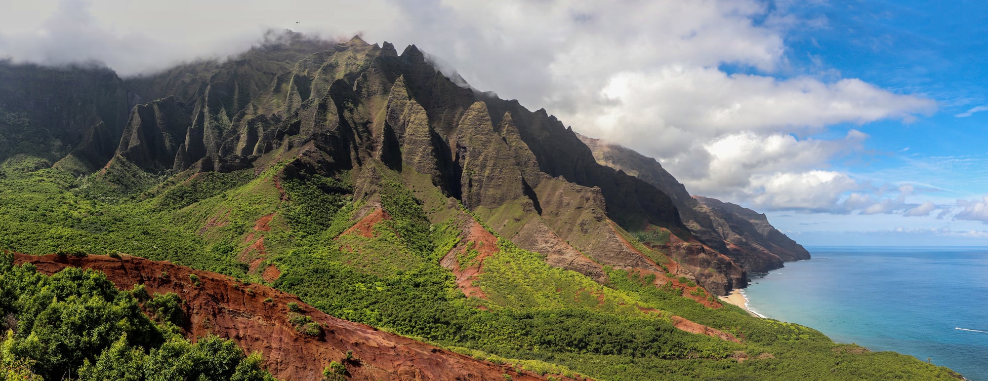
Hawaii doesn’t seem like the kind of place that would try to kill you. The Kalalau Trail on Kauai’s Nā Pali Coast will correct that impression.
Eleven miles of trail along a coastline so remote it’s inaccessible by road. The path climbs and drops through multiple valleys, crosses streams that can flash flood without notice, and traverses muddy clifftop sections where a slip sends you straight into the ocean.
The final stretch to Kalalau Valley is the most exposed — narrow, eroded, and with little margin for error. The scenery is extraordinary.
That’s part of what makes people push on past their actual skill level.
El Caminito Del Rey — Spain
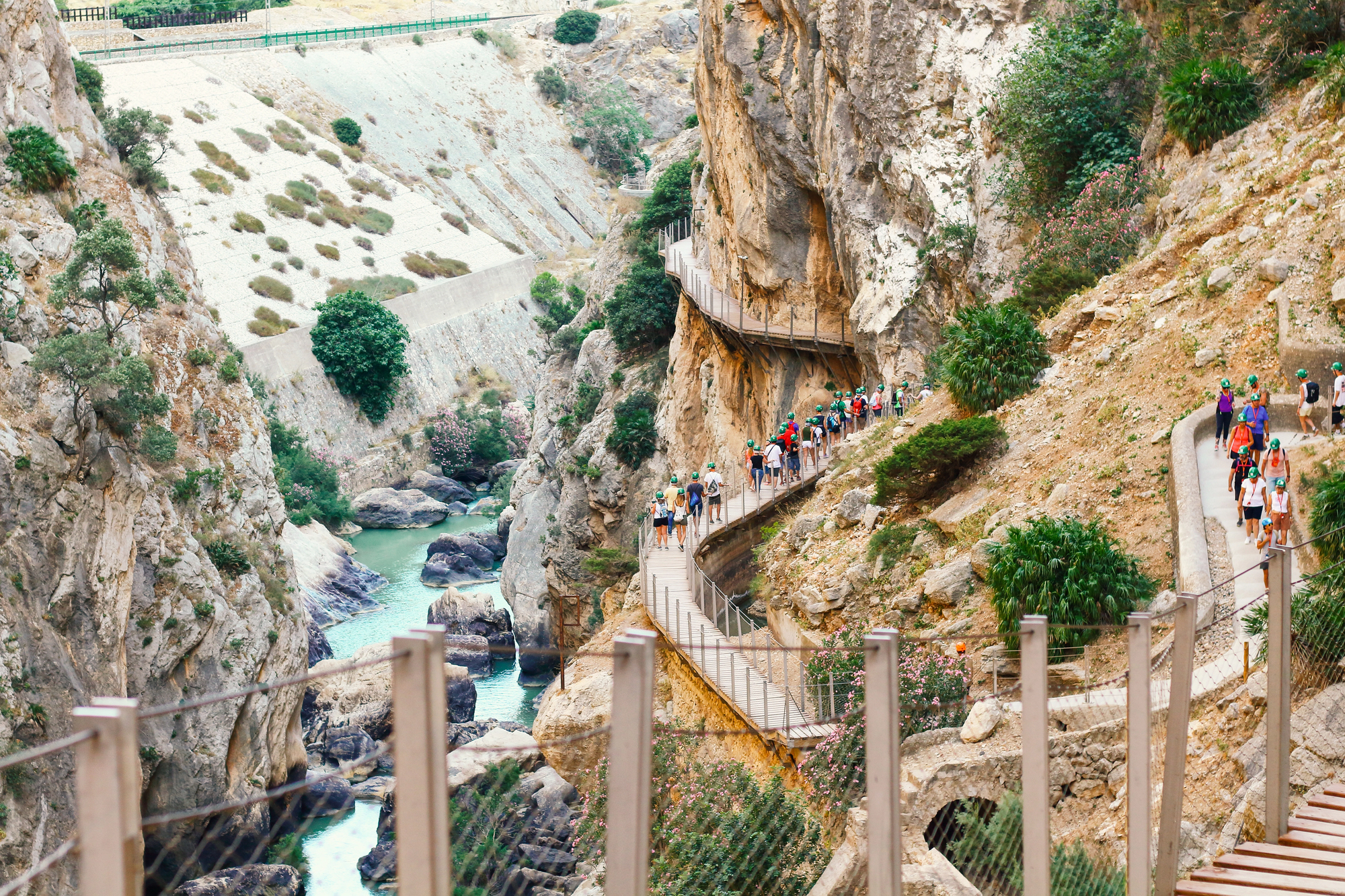
For most of the 20th century, the Caminito del Rey in Málaga was considered one of the most dangerous paths in Europe. Originally built for workers at a hydroelectric plant in the early 1900s, it was eventually abandoned and left to decay for decades.
Sections of the concrete pathway crumbled away entirely, leaving hikers to inch along exposed rock with rusted metal pins as the only handholds. Multiple fatalities closed it to the public.
The trail was restored and reopened in 2015, and it’s now considerably safer — but the exposure remains. You’re walking a narrow ledge pinned to the wall of a limestone gorge, sometimes 100 meters above the river below.
It’s no longer a death trap, but it still puts you firmly in the category of “places where falling is not an option.”
Half Dome — Yosemite, USA
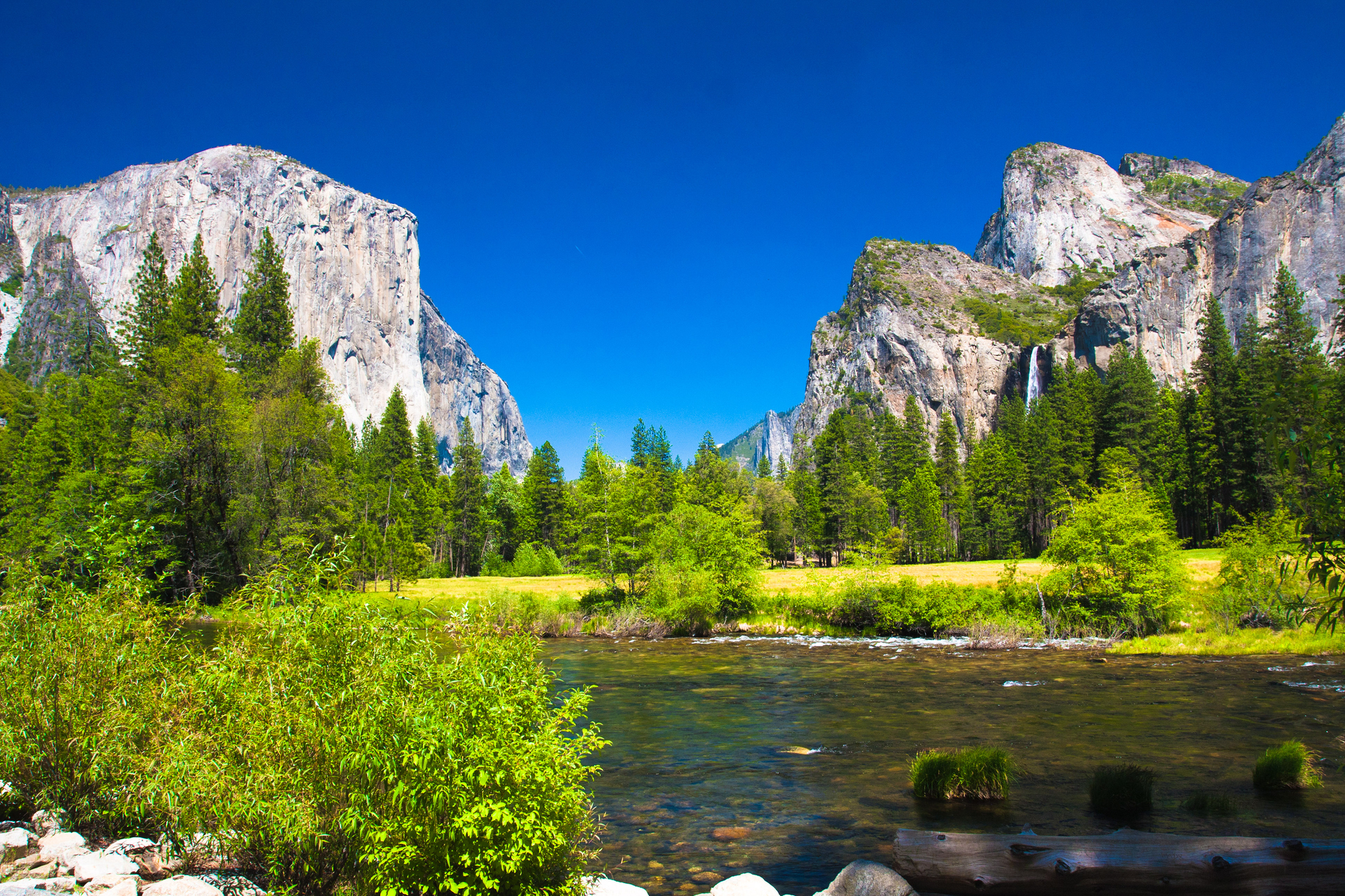
The last 400 feet of Half Dome’s summit route involve pulling yourself up a granite slope using fixed cables. The incline is steep enough that without the cables, most people couldn’t manage it.
With the cables, most people still find it deeply uncomfortable.
What makes Half Dome genuinely dangerous isn’t just the cables — it’s the afternoon thunderstorms that roll in across Yosemite with almost no warning. Lightning on an exposed granite dome is a serious threat, and the exposed summit offers nowhere to shelter.
People have been struck and killed here. The permit system limits daily traffic, but it doesn’t limit the weather.
You go early, you watch the sky, and you come down before noon if you have any sense.
Kokoda Track — Papua New Guinea
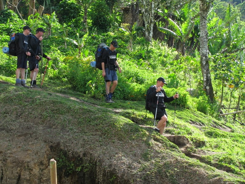
The Kokoda Track is 96 kilometers of dense jungle, steep ridgelines, and near-constant rainfall in Papua New Guinea. It climbs and descends the Owen Stanley Range through terrain that was the site of fierce fighting during World War II — and the ground hasn’t changed much since.
Hikers typically take 8 to 10 days to complete it. The difficulty isn’t one dramatic moment of danger but a relentless accumulation of physical strain: unbearable humidity, trails turned to mud, river crossings, and altitude shifts that exhaust even seasoned walkers.
Malaria is a real concern. Injuries in remote sections mean a long, complicated evacuation.
This one demands serious fitness and serious preparation.
Aonach Eagach Ridge — Scotland
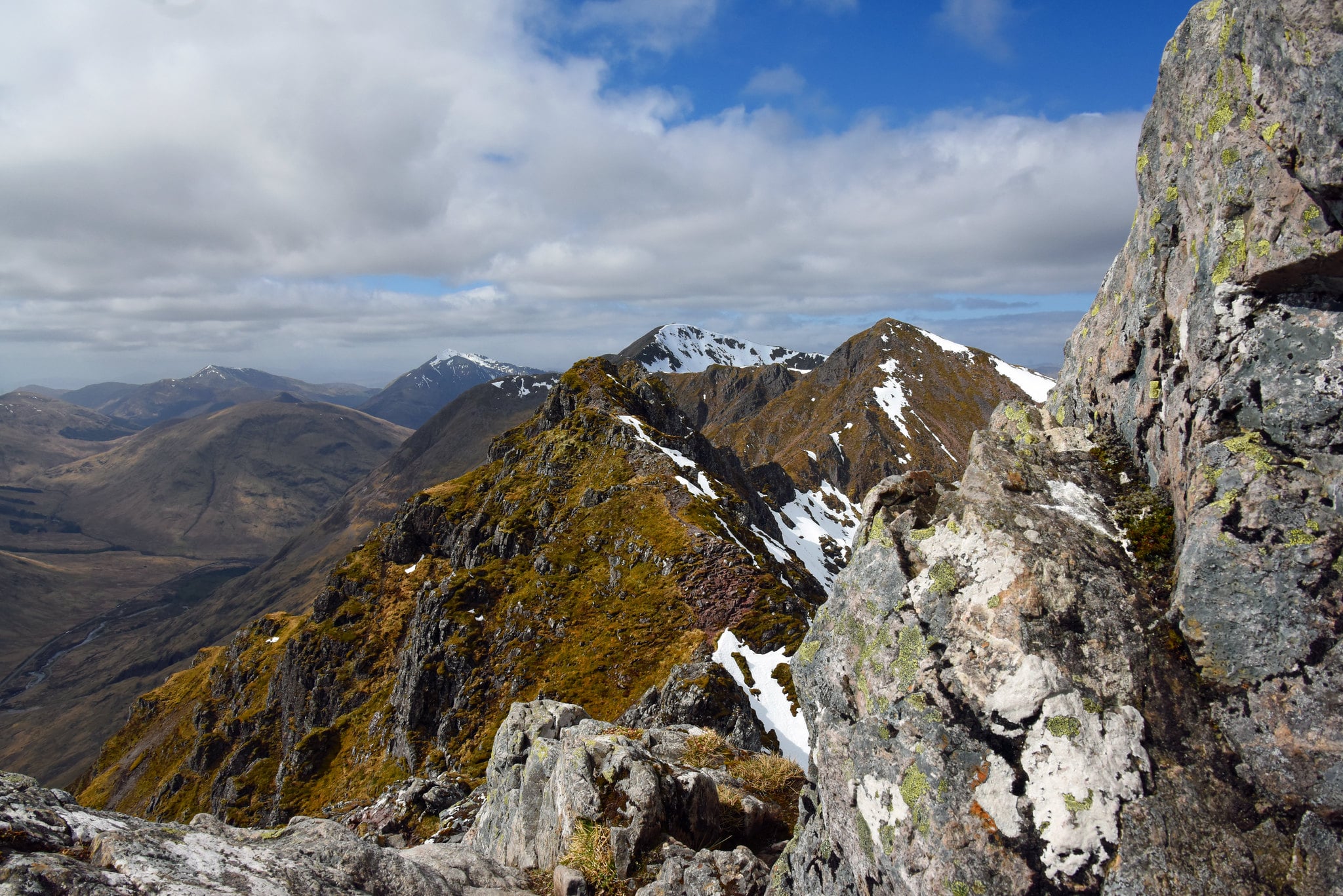
Scotland looks deceptively gentle from a distance. The Aonach Eagach ridge in Glencoe disabuses you of that notion quickly.
This is the narrowest ridge on the Scottish mainland, a two-kilometer crest of jagged pinnacles above a 3,000-foot drop on either side. It’s a Grade 3 scramble — meaning you’re on all fours for significant sections, moving across loose and exposed rock.
Once you’re on the ridge, there’s no sensible escape route until the far end. In summer, this is a formidable challenge.
In winter, when the rock is iced and the wind is fierce, it becomes something else entirely.
The Maze — Canyonlands, Utah, USA
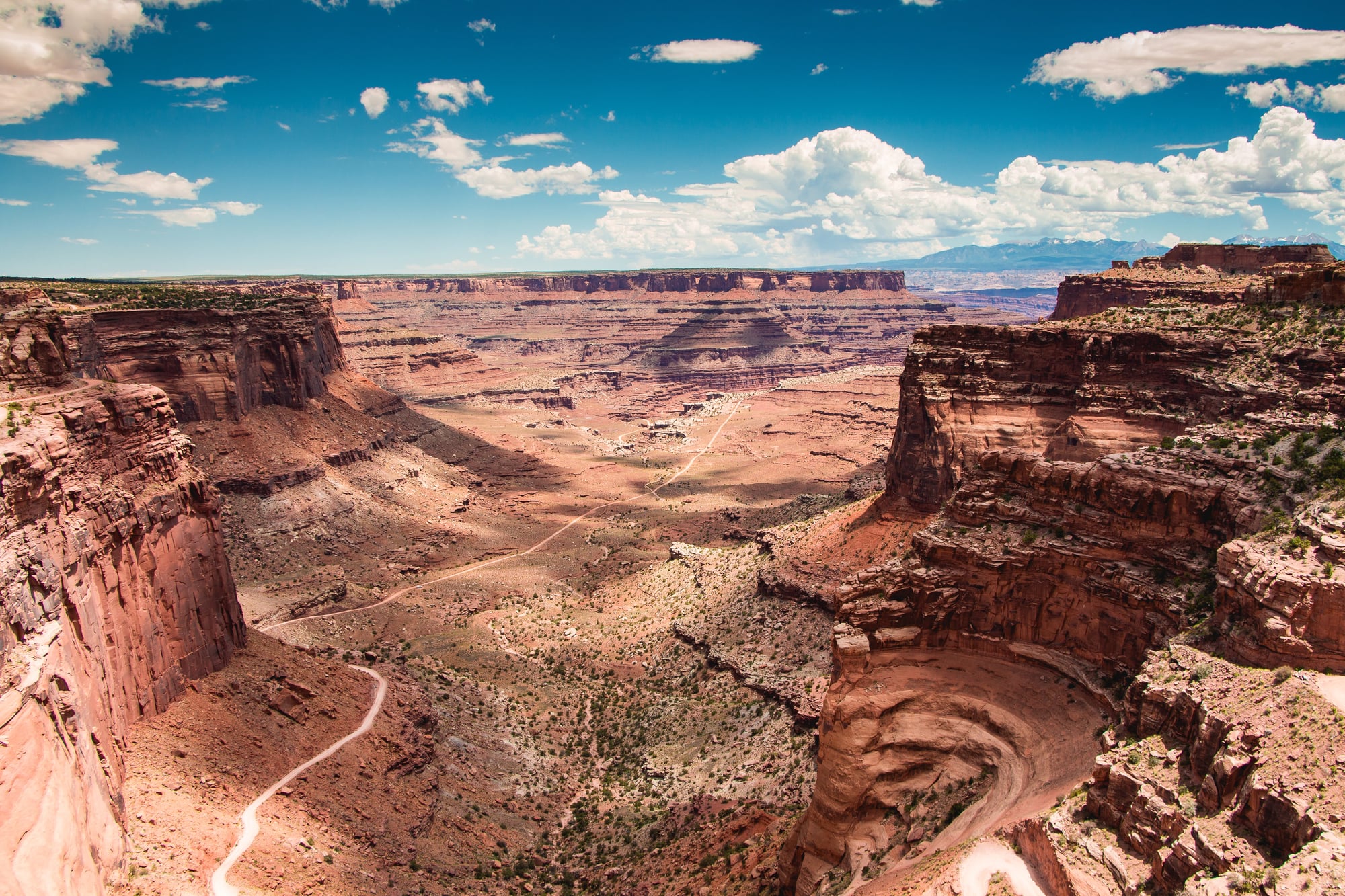
Most trails that make dangerous-trail lists are dangerous because of physical difficulty. The Maze in Canyonlands is dangerous primarily because of isolation.
There are no services, no cell coverage, no marked trails in any conventional sense, and getting out requires the same skill and navigation that getting in requires. Rangers strongly recommend carrying at least a gallon of water per person per day in summer, when temperatures regularly exceed 100°F.
Getting lost in the Maze is easy. Getting rescued is slow and expensive.
The landscape is spectacular — carved sandstone canyons in shades of red and orange that seem impossible — but the beauty is entirely indifferent to whether you make it back.
Mount Washington — New Hampshire, USA
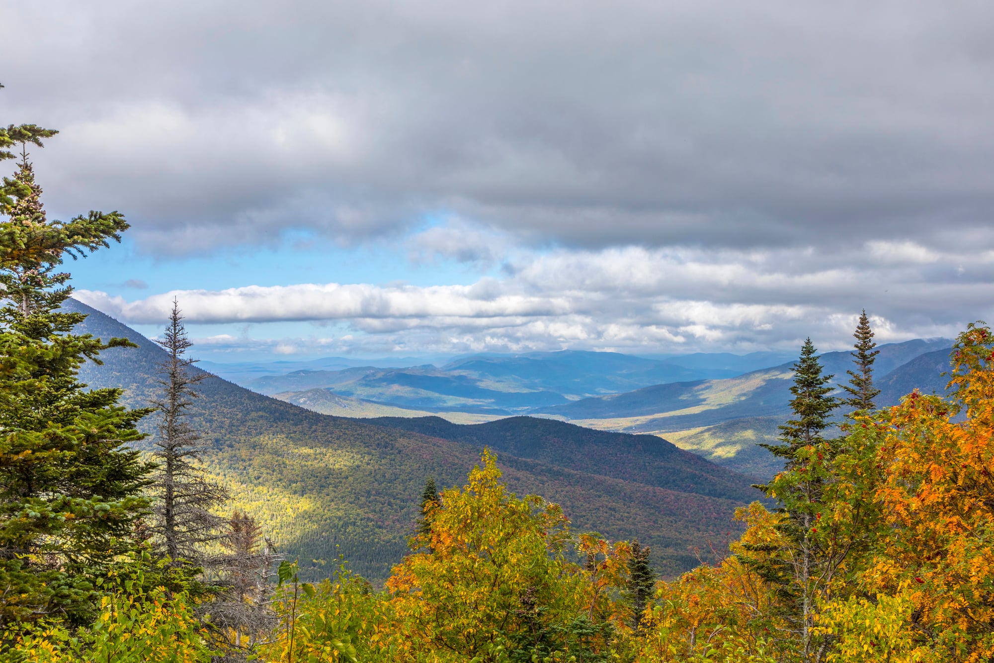
The summit of Mount Washington holds a weather record: the highest wind speed ever recorded on Earth’s surface before modern measurement systems — 231 miles per hour in 1934. The mountain sits at the intersection of three major storm tracks, and conditions at the top bear no relationship to conditions at the base.
At only 6,288 feet, it doesn’t sound threatening. But the combination of extreme cold, wind, ice, and rapidly changing weather has killed over 150 people.
Summer hikers have been caught in sudden blizzards. The auto road to the summit carries a bumper sticker that reads: “This Car Climbed Mt. Washington.”
The trails that climb it on foot are a different matter entirely.
K2 Base Camp Trek — Pakistan
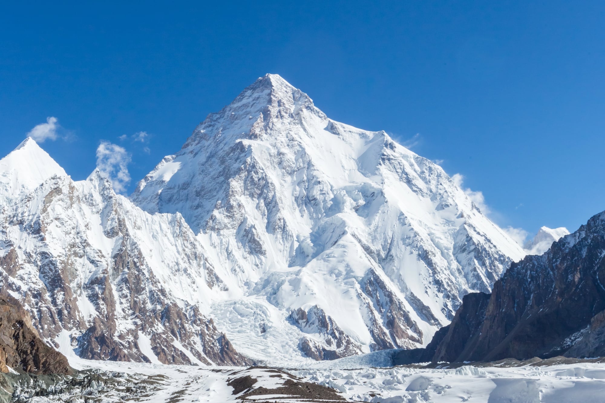
Reaching even the base camp of K2 — the second-highest mountain on Earth — is not a casual undertaking. The approach through the Karakoram Range involves multi-day walks on glaciated terrain, river crossings on sketchy bridges, and altitude that starts affecting your body well before you arrive.
K2 itself has a fatality rate significantly higher than Everest. Base camp sits at roughly 5,000 meters, and the altitude alone causes serious problems for people who ascend too quickly.
Rockfall and icefalls are common on the Baltoro Glacier approach. This trek requires proper acclimatization planning, experienced guides, and a realistic read of your own physical limits.
Drakensberg Grand Traverse — South Africa And Lesotho
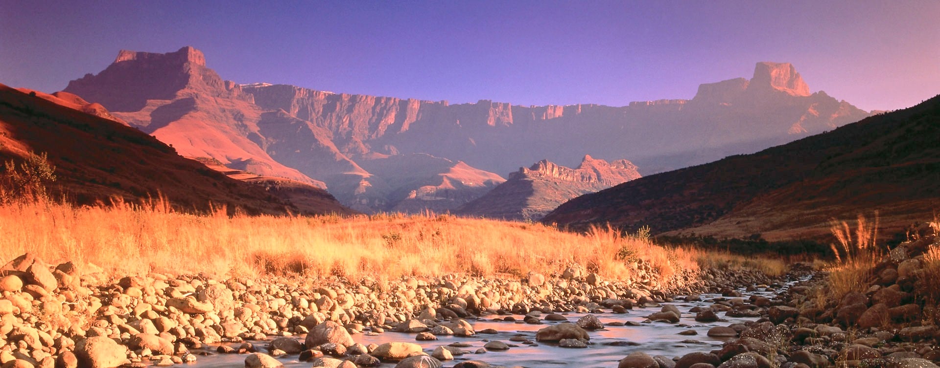
The Drakensberg Grand Traverse stretches roughly 220 kilometers across a rugged edge separating South Africa and Lesotho – few hikes on the continent demand so much. Above 3,000 meters, it cuts through an open plateau where cover is scarce, and the weather shifts fast.
Thunderstorms often rise by midday, sudden and fierce, catching hikers off guard. Few spots offer safety when skies turn dark, making timing critical.
This route tests endurance more than most, winding through raw, exposed terrain with little room for error. Weeks pass before most finish the crossing.
When streams vanish, finding water gets hard; meanwhile, reading the land demands sharp attention. Storms hit without warning across those highlands.
Distance turns dangerous because help stays far – imagine walking seven days to reach pavement, then clouds roll in.
Thorong La Pass Nepal
A winding trail through high mountains, the Annapurna Circuit saves its toughest test for the middle: Thorong La Pass looms at 5,416 meters. Hikers step out while stars still shine, aiming to climb through darkness.
Reaching the top happens under first light. Descent follows quickly because skies shift by midday.
Weather waits for no one once clouds roll down. High up, breathing gets tough, yet many ignore how hard it hits.
Some quit each day since their lungs refuse to adjust. Pushing forward while dizzy or sick might lead to fluid in the brain or lungs – either one could end things fast.
Though plenty have walked this path before, thin air leaves little room for slipups.
Carstensz Pyramid Approach Indonesia

High up in Papua, Indonesia, Carstensz Pyramid stands as Oceania’s tallest mountain – also part of the famed Seven Summits. Reaching its foot isn’t quick or simple; just getting there means moving across thick rainforest, then climbing bare limestone edges where hardly any paths exist.
Few travelers ever make the journey because support systems are nearly absent throughout the area. Getting up the mountain means tough climbs high above sea level, yet just reaching the base tests your limits too.
Even before that, securing permission takes effort because access rules are strict and local conditions tense. Moving through land shaped by dense forest all the way to rocky heights drains energy while confusing direction.
Forget roads leading clearly forward – there is no starting sign or place to leave a car behind.
Muir Snowfield On Mount Rainier In The USA

Above Mount Rainier’s tree line, the path to Camp Muir cuts across the Muir Snowfield. Summer light gives it a tame appearance, almost inviting.
Yet what seems like a simple trek turns sharp when unprepared hikers arrive lacking ice axes or route sense. Skilled climbers move steadily here, used to snow under boots.
But each year brings others – drawn by views – who step onto the field unequipped. Conditions shift fast, leaving little room for error.
White stretches in every direction, bare of any markers. When fog rolls in – a common event – sight fails completely.
Some hikers vanish each year, lost despite clear skies above. Hidden cracks sleep under thin layers, wider when warmth builds.
Ice spikes and route sense? Not rules on paper, though survival demands both. That gap between law and need keeps catching travelers off guard.
Trolltunga – Norway
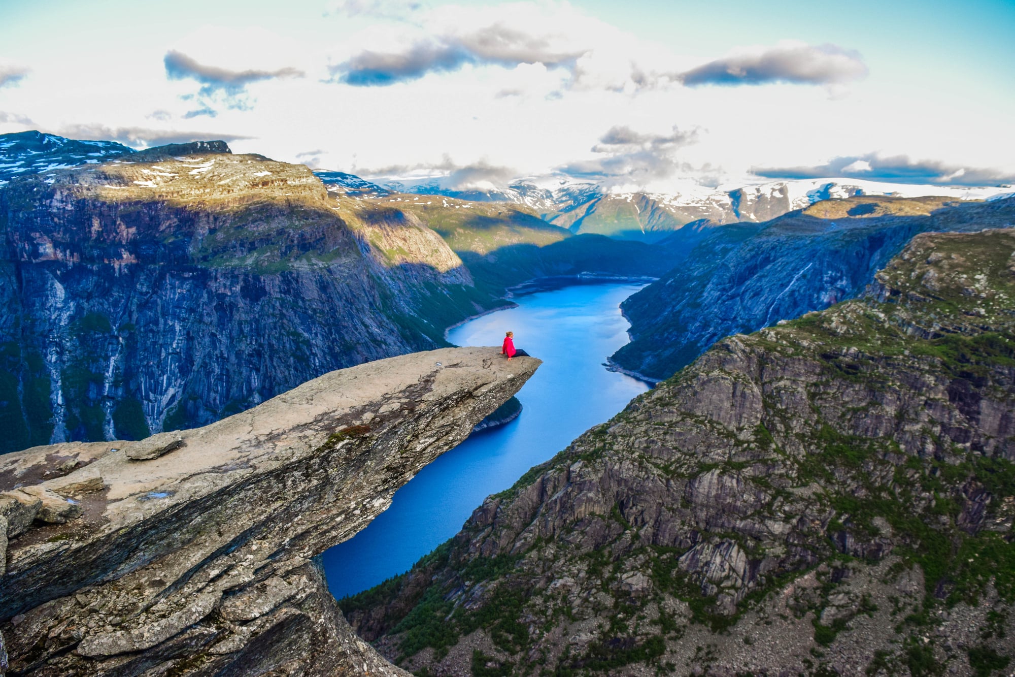
A lone figure perches on a flat stone arm stretching into space above a deep-cut fjord in Norway, seven hundred meters down to the water. This view defines Trolltunga for most who’ve seen it – fixed in countless photos across ten years.
The picture traveled far, pulling crowds toward a path less suited for casual walks. Covering roughly 22 kilometers there and back, this path climbs sharply, while skies above shift without warning across this stretch of Norway.
Slipping catches folks off guard – now and then sending them tumbling – mostly because they expect mild terrain. Pictures online made Trolltunga famous, yet show little of how snow grips the route by October, unlike summer’s clear paths.
When temperatures drop, darkness comes early, leaving some unprepared stuck, even lost forever.
Where The Trail Ends

A different kind of trail safety lives in checklists, forecasts, rules on paper. That one helps – sure – but doesn’t tell the whole story.
Up high, where trees thin out, even those with strong shoes, clear plans, and steady friends have vanished. Turning back splits those who return from those who vanish.
Each path here holds a line past which few go – real or felt – yet stepping away before crossing it rarely wins tales, though it builds years. That peak stays put.
The narrow bridge remains fixed. Nothing forces this moment now.
More from Go2Tutors!

- The Romanov Crown Jewels and Their Tragic Fate
- 13 Historical Mysteries That Science Still Can’t Solve
- Famous Hoaxes That Fooled the World for Years
- 15 Child Stars with Tragic Adult Lives
- 16 Famous Jewelry Pieces in History
Like Go2Tutors’s content? Follow us on MSN.