Strange Facts About Weather Phenomena
Weather does more than just decide whether you need an umbrella or sunglasses. Sometimes the atmosphere puts on shows so bizarre that they seem pulled straight from science fiction.
From lightning that never stops to underwater ice stalactites that kill everything they touch, these strange weather events prove that nature has a wild imagination.The sky holds secrets most people never witness.
Here’s a list of 16 strange facts about weather phenomena—from rain that evaporates mid-air to clouds you can actually surf—that will change how you look at what’s happening above your head.
Virga
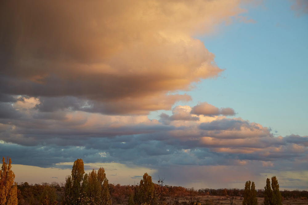
Rain that never reaches the ground sounds impossible, but virga makes it happen regularly. When precipitation falls from clouds through extremely dry air, it evaporates completely before touching the surface.
What remains are ghostly streaks extending downward from cloud bases, marking the path rain took before vanishing into vapor. The evaporation process sucks so much energy from the surrounding air that it can create dangerous microbursts, sending concentrated parcels of cold air and water crashing down with surprising force.
Heat Bursts

Waking up at midnight to find the temperature has jumped 20 degrees and 80-mile-per-hour winds tearing through town sounds like a fever dream. Heat bursts make this nightmare real.
These rare events occur when dying thunderstorms high in the atmosphere rain into hot, dry air below, and the water evaporates rapidly, cooling and compressing the air until it becomes so dense it plummets toward the ground. As it falls and gets squeezed by atmospheric pressure, it heats up dramatically—sometimes causing temperatures to spike by 30 degrees in just minutes.
Like Go2Tutors’s content? Follow us on MSN.
Haboobs

Massive walls of dust thousands of feet high and miles wide can swallow entire cities in moments. Haboobs form when thunderstorms collapse and either blast out all their collected air in powerful gusts or drop cold air rapidly in a microburst.
These strong winds race ahead of the storm, picking up every loose particle in their path. The result? An advancing wall that looks like something out of an apocalypse movie.
Northern Africa and the southwestern United States see these most often, thanks to their abundance of hot, dry air and loose sediment.
Waterspouts

Tornadoes made of water sound less threatening than their land-based cousins, but they’re every bit as real. Most waterspouts actually form in fair weather directly on the water’s surface when warm temperatures and high humidity cause air to rise with enough strength to pull water up into a spinning funnel.
These fair-weather versions rarely exceed EF0 intensity and usually last fewer than 20 minutes. The unexpected bonus is that they’re responsible for those bizarre reports of fish and frogs raining from the sky, as unsuspecting marine life gets sucked up and deposited miles away over land.
Mammatus Clouds
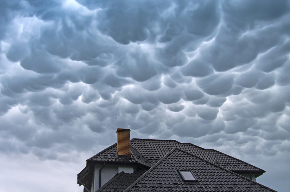
Clouds that look like giant bubble wrap hanging from the sky tend to make people nervous. And for good reason.
Mammatus clouds form when cold, sinking air pockets push down on the cloud base, creating distinctive pouch-like bulges that resemble an upside-down egg carton. They typically appear during or after thunderstorms, and while they look absolutely menacing with their lumpy, pendulous appearance, they’re mostly harmless.
The smooth bottoms and textured tops create an otherworldly scene that has occasionally been blamed on UFOs by those unfamiliar with the phenomenon.
Like Go2Tutors’s content? Follow us on MSN.
Sun Dogs
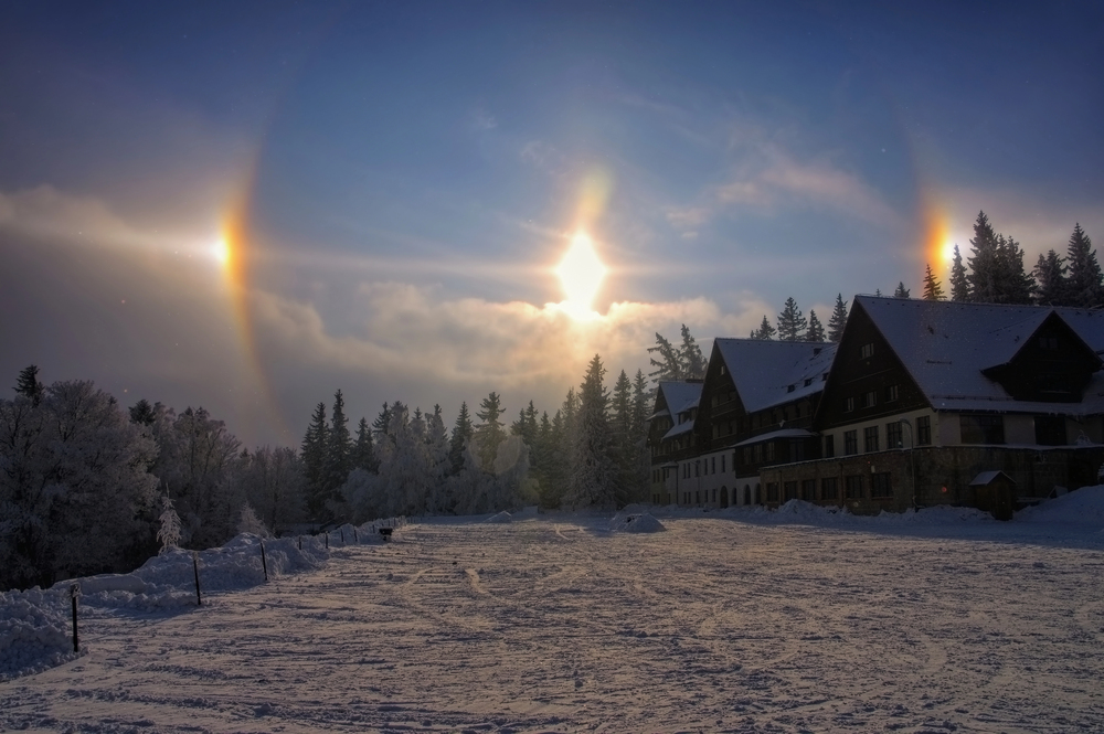
Seeing three suns in the sky used to terrify ancient civilizations. Sun dogs are just ice crystals playing tricks with light.
These bright spots appear on either side of the sun when sunlight refracts through hexagonal ice crystals suspended in the atmosphere. The crystals act like tiny prisms, bending light to create what looks like companion suns flanking the real one.
They’re more common in colder regions where ice crystals are abundant, and they often display rainbow-like colors similar to the real sun. A similar effect can occur around the moon, though it’s seen less frequently due to the moon’s dimmer light.
Fire Rainbows
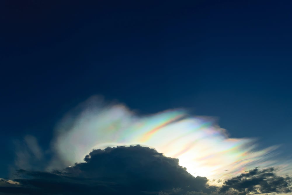
Despite the name, fire rainbows involve neither fire nor rain, but they’re spectacular nonetheless. Officially called circumhorizontal arcs, these phenomena occur when sunlight passes through flat, hexagonal ice crystals in high-altitude cirrus clouds at just the right angle.
The sun must be at least 58 degrees above the horizon, and the ice crystals need to be perfectly horizontal with their faces parallel to the ground. When everything aligns, the entire section of cirrus cloud acts like a giant prism, creating a rainbow-like band that stretches parallel to the horizon.
People in the United States see them several times each summer, still they’re nearly impossible to spot north of 55 degrees latitude.
Light Pillars
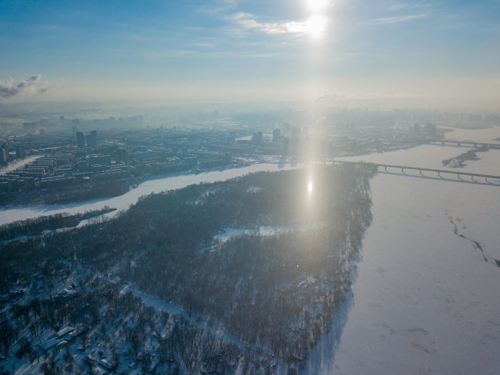
Vertical beams of light shooting up from the ground or down from the sun look supernatural. They’re just well-positioned ice crystals doing their job.
Light pillars form when flat, hexagonal ice crystals float horizontally near the ground during cold weather, reflecting light between their surfaces. When the light source is the sun near sunset or sunrise, pillars appear to rise from or descend toward the horizon.
Ground-based light sources like street lamps can create even taller pillars since the observer is closer to the crystals, and the crystal orientation matters less when you’re standing right beneath the effect.
Like Go2Tutors’s content? Follow us on MSN.
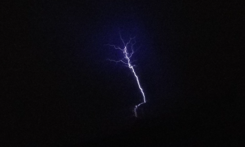
Catatumbo Lightning
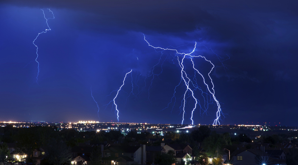
Lightning that strikes up to 280 times per hour for 160 nights a year sounds exhausting, and that’s exactly what happens over Lake Maracaibo in Venezuela. The Catatumbo River region experiences the highest concentration of lightning on Earth, with 233 flashes per square kilometer annually.
Warm Caribbean winds collide with cold air descending from the Andes Mountains, creating perfect conditions for perpetual electrical storms. The phenomenon has been so reliable throughout history that it served as a natural lighthouse for ships navigating to Maracaibo, visible from 250 miles away.
It mysteriously stopped for three months in 2010, baffling scientists before resuming its regular schedule.
Orb Lightning
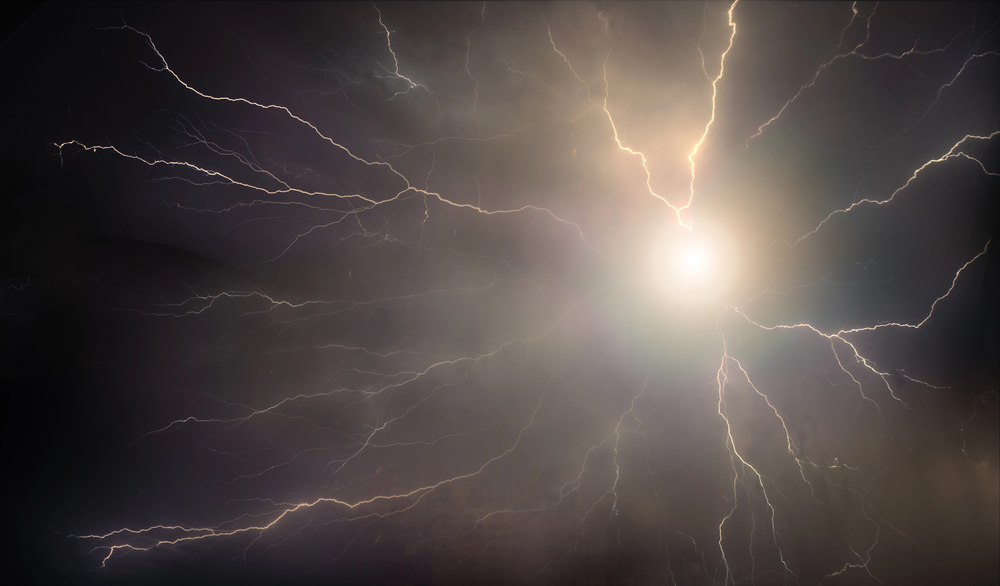
Glowing spheres of plasma that float through rooms and occasionally explode remain one of weather’s greatest mysteries. Orb lightning appears during thunderstorms as luminous orbs ranging from golfballl to beach sphere size, drifting eerily through the air for a few seconds before vanishing or bursting. During World War II, pilots reported these glowing spheres pacing their aircraft and called them ‘foo fighters,’ later inspiring the band name.
Despite numerous eyewitness accounts spanning centuries, scientists still struggle to explain exactly how orb lightning forms, and it remains nearly impossible to predict or study since it appears so randomly and briefly.
Blood Rain
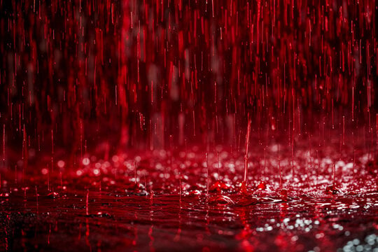
Red rain falling from the sky has terrified people since ancient times, and it still happens today. In 2001, southern India experienced weeks of crimson showers following a reported boom in the sky, with some witnesses claiming the rain was so intense that trees shed their leaves and turned gray.
Modern scientists blame the color on algal spores or desert dust carried by winds. Even so, historical records of blood rain stretch back to eighth-century Europe, where it was seen as a divine omen of war. The phenomenon occurs when particles suspended high in the atmosphere mix with rain clouds, turning precipitation various shades of red, and occasionally yellow, green, or black.
Like Go2Tutors’s content? Follow us on MSN.
Sprites and Blue Jets
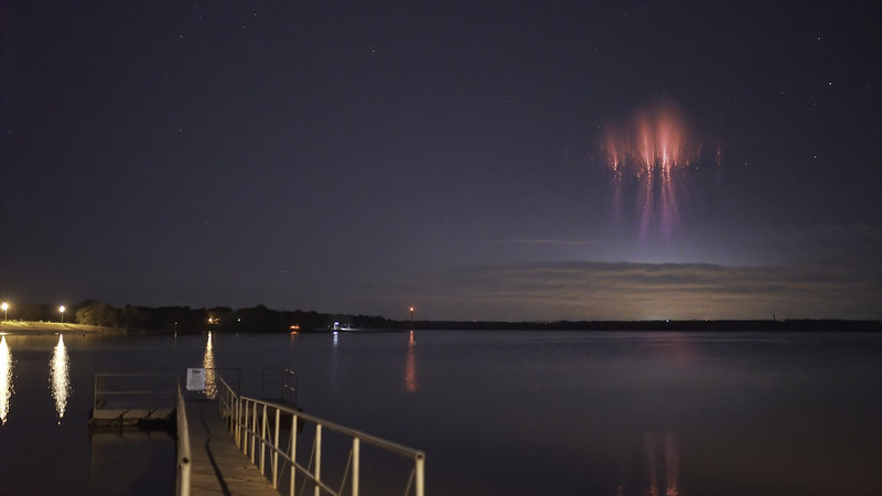
Lightning that shoots upward into space rather than down to earth belongs in the realm of science fiction. Except it happens during intense thunderstorms.
Red sprites are large, crimson discharges that shoot 50 to 90 kilometers above thunderclouds, while blue jets are blue lightning bolts that emerge from storm tops. They’re created when powerful positive lightning from clouds meets negative lightning from the ground, generating an intense electric field in the upper atmosphere.
These phenomena last only fractions of a second and were often dismissed as myths until high-speed photography finally captured them on film.
Morning Glory Clouds
Giant rolling tubes of cloud stretching 600 miles across the sky and traveling at 45 miles per hour are the atmospheric equivalent of a tsunami. Morning Glory clouds form most predictably in northern Australia’s Gulf of Carpentaria, appearing as low-hanging cylindrical formations that can reach heights of over a mile.
Colliding sea breezes from the peninsula and surrounding waters create these rare waves, which roll continuously as cloud forms at the leading edge and evaporates at the trailing edge. Glider pilots travel from around the world to surf these clouds like aerial waves.
The town of Burketown has become famous for offering the best viewing opportunities from September to November.
Snow Rollers
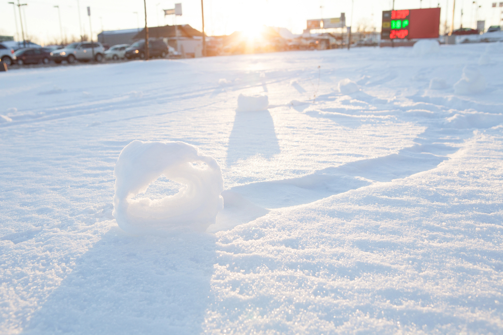
Nature occasionally makes its own snowballs without any human help, and they’re often shaped like donuts. Snow rollers form when wind blows chunks of snow across the ground under very specific conditions: a thin layer of wet snow on top of ice or powder, temperatures near freezing, and wind strong enough to move snow but not destroy it.
As the snow tumbles along, it picks up more material and grows into a cylinder rather than a sphere. The inner layers are so weak and thin that they often blow away, leaving a hollow center that resembles a Swiss roll or donut.
These formations can range from tennis orb size to larger than a car, which is wild when you think about it.
Like Go2Tutors’s content? Follow us on MSN.
Brinicles
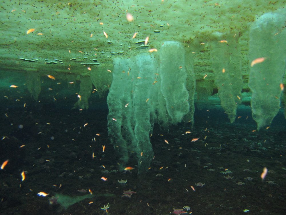
Known as the “icy fingers of death,” underwater icicles are as lethal as they seem, killing everything they come into contact with. When pockets of extra-salty brine seep out and sink into the ocean below, brinicles are created beneath the Antarctic and Arctic sea ice.
The surrounding less-salted seawater is instantly frozen by the brine’s extreme cold, forming a hollow tube of ice that descends like an underwater stalactite. Starfish, sea urchins, and anything else that is too slow to escape are encased in a web of ice that is created when a brinicle breaks open and spreads across the seafloor.
For their 2011 season of Frozen Planet, the BBC recorded the first time-lapse of a brinicle forming.
St. Elmo’s Fire
For centuries, sailors and pilots have been baffled by the appearance of glowing blue plasma on ship masts and airplane wings during storms. This electrical phenomenon, which bears the name of St. Erasmus, the patron saint of sailors, happens when storm-generated electricity turns gas molecules around sharp objects into plasma.
The end effect is a bluish glow that focuses on sharp objects like animal horns, church steeples, masts, and lightning rods. St. Elmo’s Fire does not strike suddenly like lightning does; instead, it discharges continuously.
Despite its unsettling appearance, it is entirely harmless.
The Atmosphere’s Wild Side
These strange phenomena reveal that weather operates on scales and in ways most people never imagine. What appears as simple rain or clouds on an average day represents just the surface of atmospheric complexity.
The sky continues generating mysteries that challenge our understanding, from perpetual lightning storms to ice formations that spread death across the ocean floor. Each unusual event offers a glimpse into the raw physics governing our planet, reminding us that the boundary between earth and space remains one of the most dynamic and unpredictable zones we know.
More from Go2Tutors!

- 16 Historical Figures Who Were Nothing Like You Think
- 12 Things Sold in the 80s That Are Now Illegal
- 15 VHS Tapes That Could Be Worth Thousands
- 17 Historical “What Ifs” That Would Have Changed Everything
- 18 TV Shows That Vanished Without a Finale
Like Go2Tutors’s content? Follow us on MSN.