Cities With The Strangest Street Layouts
Some towns spread out following patterns you can almost guess – along waterways, around slopes, tracing trails left behind by wandering herds, shaped by those calling the shots years ago. Yet others appear built on a dare, tossing navigation aside, drawn up as if order meant something entirely new.
A few look less planned, more dreamed up after midnight. Buckle up for a walk through city designs that veered off track in the most delightful ways.
You might feel thankful for your own neighborhood – or completely jealous – if wandering without direction excites you.
Boston’s Colonial Tangle

Twisting through Boston feels less like following streets, more like tracing old cow tracks frozen into pavement. One by one, narrow lanes sprouted where settlers once walked, never arranged – just added.
Washington Street bends around Tremont, then loops near Boylston, forming knots few can predict. Locals shrug when asked for directions; their answers often start with “well, sort of.”
Digital maps flicker, recalculate, sometimes give up mid-block. Car rentals list downtown as a zone with extra fees, buried in fine print.
Finding your way here becomes its own kind of trial, unannounced but clear.
Medieval Fez, Morocco

Winding through Fez el-Bali feels like stepping into a maze built centuries ago. With nearly 9,000 alleyways twisting in every direction, few carry any name you could write down.
Squeezed between tall buildings, certain passages barely allow room – shoulders must turn if two meet head-on. Because cars simply cannot squeeze through, donkeys move goods just as they did long before engines arrived.
This ancient part of Morocco stays unchanged, its pathways resisting modern traffic by design.
Venice’s Water Grid
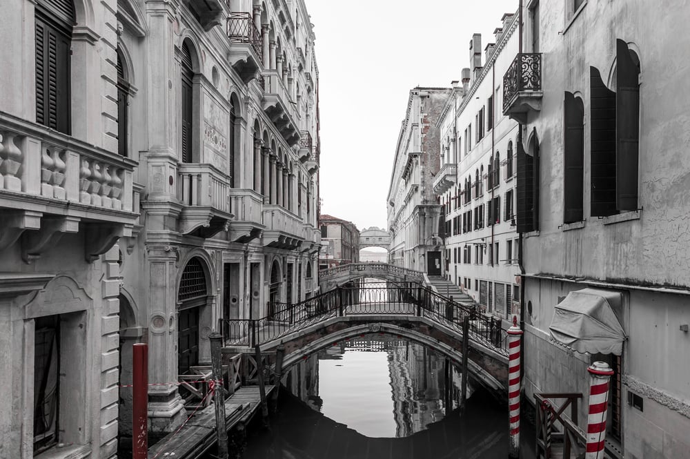
Waterways take the place of roads in Venice – charming, yes, but less so when you just want to reach a destination. About 400 bridges link its 118 islands, yet the routes twist back on themselves like tangled threads.
Even locals misstep now and then, caught out by a sudden stop where a path should continue. Tourists arriving for the first time often find themselves halted by open water, boots planted at the last slab of pavement.
Tokyo’s Address System

Most roads in Tokyo go unnamed. What stands out is how addresses rely on blocks, numbers assigned based on construction date rather than position.
A structure labeled 14 might stand directly beside another marked 37. Because of this, even residents point to nearby shops or soda machines when explaining where to go.
Postal workers here must master the puzzle, treated almost like human maps.
Diagonal Avenues Of Washington D C

Back in the late 1700s, planners laid out Washington D.C. using a rigid square pattern. Yet, Pierre Charles L’Enfant tossed in wide roads slanting at angles, each tagged with a state’s name, slicing through the layout.
Because of this mix, odd-shaped crossings popped up everywhere, leaving behind wedge-like patches of land tucked between streets. To handle the confusion, roundabouts appeared – Dupont Circle, Logan Circle, Thomas Circle – all meant to smooth things over, though they often made it messier instead.
Moving around by car here means staying alert in ways you never would on straightforward blocky streets.
Ahmedabad’s Walled City Pols
Twisting inward like tangled threads, the old city of Ahmedabad unfolds in pockets called pols – clusters of houses huddled along narrow lanes. Purpose shaped these paths, built so intruders would struggle to pass through.
Deeper inside, the passages tighten, slowing anyone unfamiliar. Each resident carried the route in memory; visitors rarely grasped it at all.
Bern, Switzerland’s Zähringen Grid
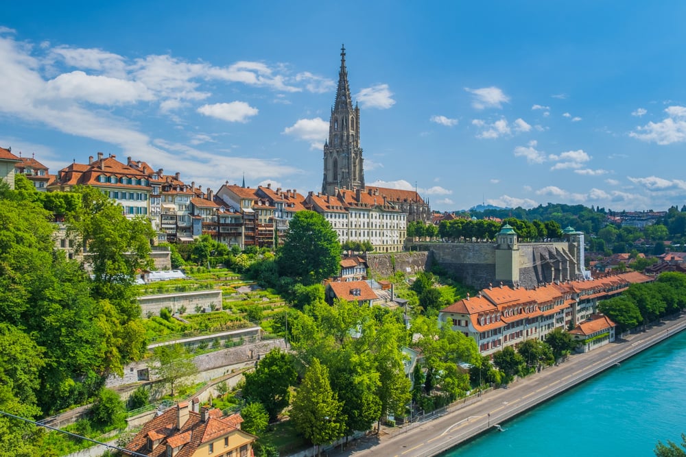
Bern looks neat on a map because it was built in the 12th century on a long, narrow peninsula surrounded by the Aare River. Every street runs in one direction, which sounds simple until the pedestrian arcades, underground passages, and hillside terraces come into play.
The city has more than 6 kilometers of covered walkways that weave between and under buildings. What looks orderly from above is surprisingly disorienting at ground level.
Mumbai’s Mill District
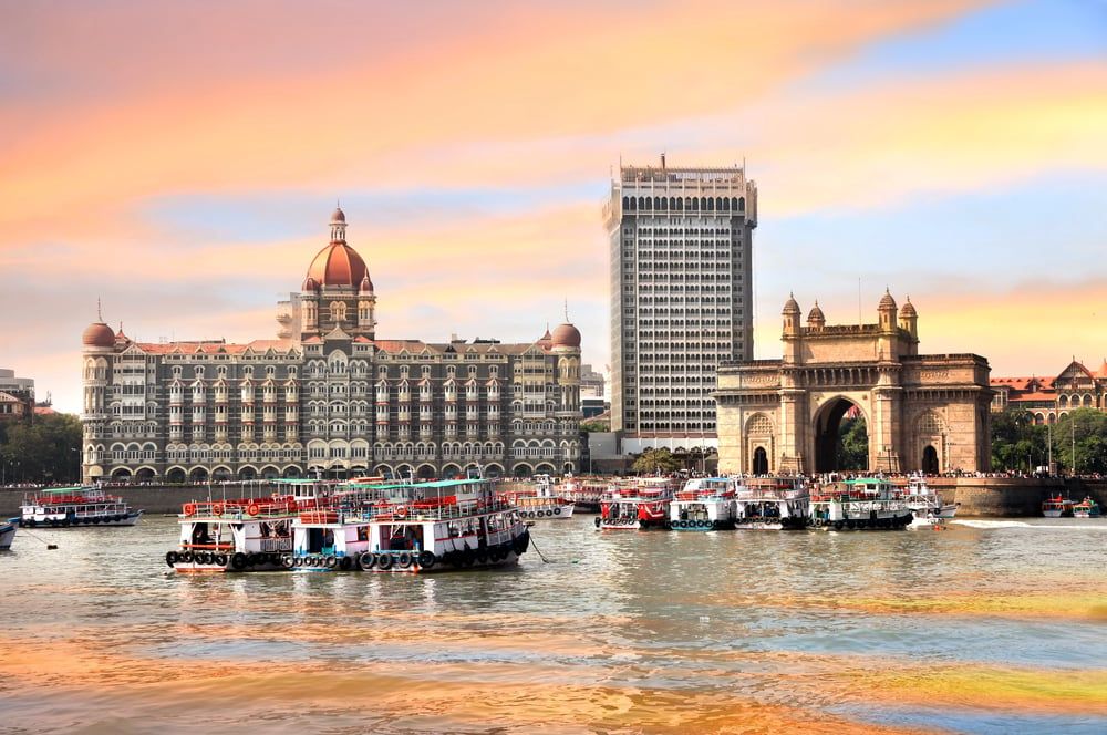
Large parts of central Mumbai grew around old textile mills, and the streets were laid out to serve factory workers and supply chains, not city-wide navigation. Roads end abruptly, curve sharply, or connect to other roads at odd angles.
Certain neighborhoods are almost impossible to reach by car without going in circles first. The city’s newer districts follow more logical patterns, which makes the contrast with the older areas even more obvious.
Edinburgh’s Old and New Towns

Edinburgh, Scotland, has two very different street systems sitting right next to each other. The Old Town clings to a volcanic ridge with streets that tumble downhill in a series of narrow closes and steep wynds.
The New Town, built in the 1700s, is a clean Georgian grid just a short walk away. Crossing between the two areas feels like stepping between different centuries.
The difference in street logic is so sharp that tourists often do not realize both areas sit within the same city center.
La Paz, Bolivia’s Altitude Zones
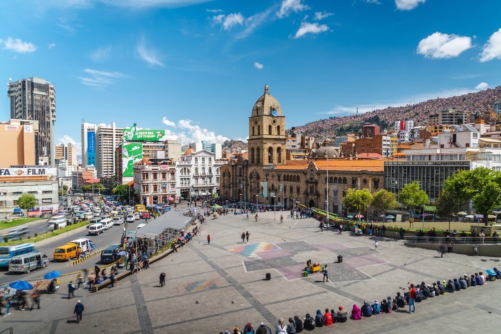
La Paz does not just have strange streets, it has streets at wildly different altitudes stacked on top of each other. The city sits inside a canyon, and roads climb the canyon walls at angles steep enough to make most drivers nervous.
Some neighborhoods in the upper city can only be reached by cable car because roads simply cannot manage the incline. The layout follows gravity more than any planning document.
Nagoya’s Wartime Rebuild

Nagoya, Japan, was heavily bombed during World War II, and city planners used the destruction as a chance to redesign the streets. Wide boulevards were built in a fairly logical grid, but the areas that were not destroyed kept their old, winding layouts.
The result is a city where certain blocks follow perfect right angles and others spiral off without warning. Driving through Nagoya means switching between two completely different navigational rules, sometimes within the same minute.
Marrakech’s Medina

The medina of Marrakech is one of the largest car-free urban areas in the world, and that is partly because no car could survive its streets for long. The lanes inside the old walls were deliberately built narrow and winding to keep the interior cool and to slow down potential invaders.
Some paths are barely wider than a bicycle. Getting from one side of the medina to the other without taking a wrong turn is genuinely considered a skill.
São Paulo’s Favela Grid
Within São Paulo’s informal settlements, known as favelas, streets were built organically as people arrived and built homes on any available space. Roads sometimes follow the edges of individual buildings or the contours of hillsides rather than any plan.
Two streets can run parallel for a short stretch and then merge unexpectedly. Navigation apps have started mapping some of these areas, but residents have always relied on local knowledge that no app can fully replace.
Manila’s Intramuros
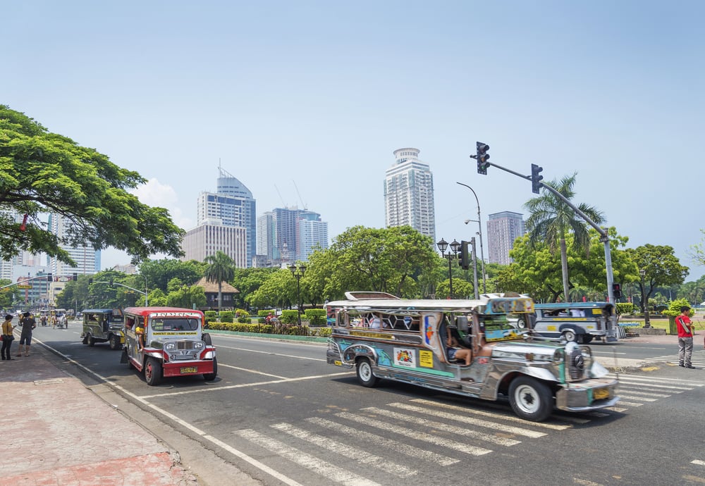
Intramuros is the old walled city at the heart of Manila, the Philippines, and its streets were designed by Spanish colonial planners in the 1500s. The original grid was tight, with narrow roads built for foot traffic and horse carts.
Centuries of additions, rebuilds after wartime damage, and growing traffic have turned those streets into a chaotic mix of wide and narrow paths that rarely connect smoothly. Getting through Intramuros by car at rush hour is considered a patience test.
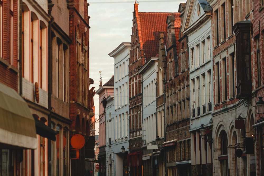
Bruges’ Medieval Canal Network
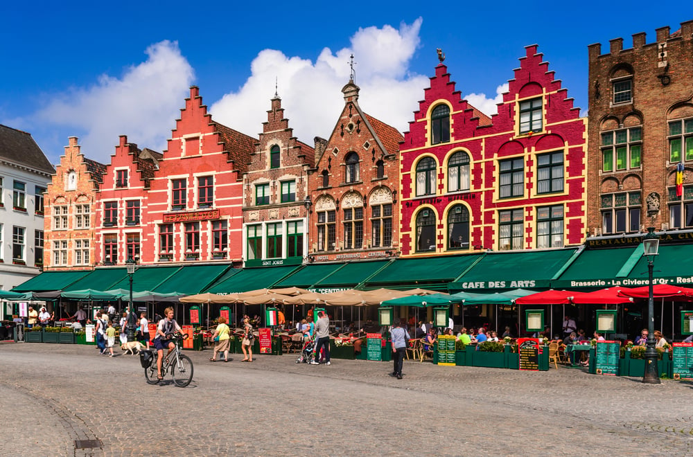
Bruges in Belgium is often compared to Venice because it also built its city around a canal system. But unlike Venice, Bruges has both canals and roads running side by side, often overlapping in confusing ways.
Streets split around canal banks, double back on themselves, and occasionally pass through archways in old buildings. Cyclists who visit for the first time tend to take twice as long as expected to reach their destination because there is always another turn that seems correct but is not.
The Streets That Cities Forget To Explain
Strange street layouts are not always accidents. Some were built for defense, some for climate, and some grew out of centuries of small decisions layered on top of each other.
What they share is a resistance to shortcuts, a quality that forces the people moving through them to slow down and pay attention. In a world where navigation has become almost fully automated, these cities offer something increasingly rare: the experience of being genuinely, productively lost.
The street is not just a way to get somewhere. In these places, the street is the destination.
More from Go2Tutors!

- The Romanov Crown Jewels and Their Tragic Fate
- 13 Historical Mysteries That Science Still Can’t Solve
- Famous Hoaxes That Fooled the World for Years
- 15 Child Stars with Tragic Adult Lives
- 16 Famous Jewelry Pieces in History
Like Go2Tutors’s content? Follow us on MSN.