Lesser-known weather terms to know
Out there beyond the usual chat about sun or snow lies words most never say aloud. Morning radio chatter mixes with checkout line remarks, always circling back to what the sky might do.
Instead of just wet days or sudden chills, some phrases capture air movement others ignore completely. Hidden inside common speech are labels for shifts in pressure, changes in wind direction nobody points out.
Each term fits like a key into moments folks feel but can’t quite explain. What slips through daily conversation is often more precise than we think.
A different angle on lesser-known terms for sky conditions – each gives a clearer picture of the air and light above, plus how it shapes our surroundings. What hides behind these quiet labels is often more precise than common phrases.
Not every shift in atmosphere has an obvious name, yet these do the work without fuss. Sharp details live here, away from the usual chatter about rain or sun.
One by one, they map subtle changes most overlook. Few people say them aloud, but they carry weight when spoken.
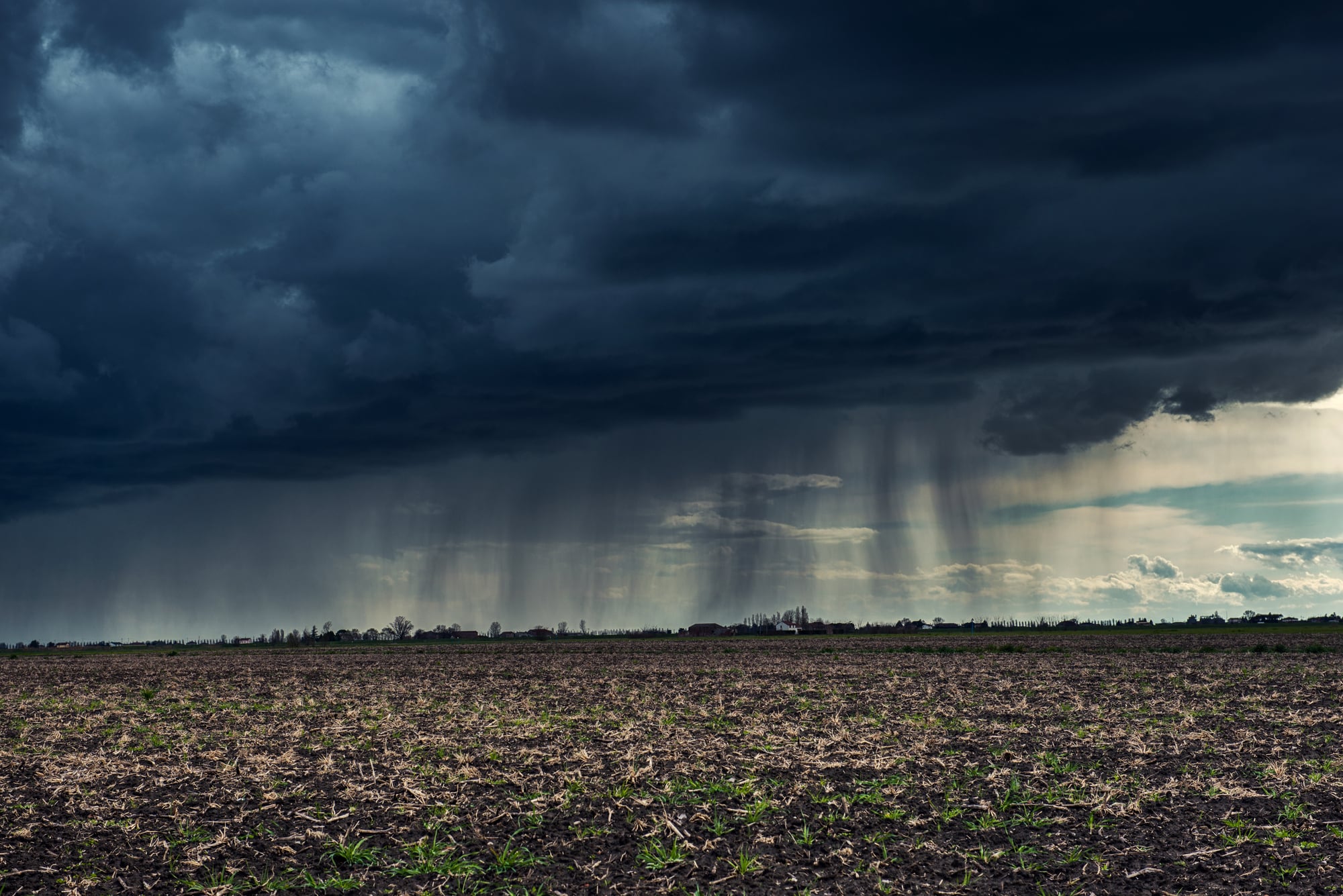
Virga
Virga looks like rain that loses interest halfway to the ground. It appears as streaks falling from clouds but evaporates before reaching the surface, often in dry or desert regions.
From a distance, it resembles a soft curtain hanging beneath a cloud, giving the impression of rainfall that never quite arrives. Pilots pay close attention to virga because it can signal strong downdrafts and shifting winds near the ground.
For everyone else, it explains those moments when the sky looks dramatic but the pavement stays stubbornly dry.
Graupel
Graupel sits somewhere between snow and hail, though it rarely gets the recognition of either. It forms when snowflakes collect supercooled water droplets that freeze on contact, creating soft, white pellets that crunch underfoot.
Unlike hail, graupel is lightweight and tends to bounce quietly rather than smash loudly. It often falls during cold, unstable conditions when the atmosphere is churning just enough to create variety in what drops from the sky.
Seeing graupel is a reminder that winter weather comes with more nuance than a simple snow-or-no-snow forecast.
Chinook

A Chinook is a warm, dry wind that sweeps down the eastern slopes of mountain ranges, most famously the Rockies. As air descends, it compresses and heats rapidly, sometimes raising temperatures by dozens of degrees in a matter of hours.
Snow can vanish with startling speed under a Chinook’s influence, earning it the nickname ‘snow eater’. Communities accustomed to these winds learn to expect dramatic mood swings from the weather, with winter days briefly borrowing the feel of early spring.
Derecho
Derecho refers to a widespread, long-lived windstorm associated with fast-moving thunderstorms. Unlike tornadoes, which are localized and rotational, derechos produce straight-line winds that can stretch hundreds of miles.
The damage they leave behind often resembles the aftermath of a powerful storm surge, with trees flattened in the same direction. Because derechos develop quickly and cover large areas, they can catch entire regions off guard.
Knowing the term helps explain why some storms feel more relentless and expansive than others.
Foehn
The foehn is a downslope wind similar to the Chinook, found in various mountainous regions around the world. As moist air rises over mountains, it cools and drops precipitation, then warms rapidly as it descends on the other side.
The result is a dry, warm wind that can feel almost out of place given the surrounding climate. Foehn winds have been linked to rapid snowmelt, increased wildfire risk, and even shifts in human mood.
They are a striking example of how terrain shapes local weather in dramatic ways.
Fallstreak Punch
A fallstreak punch looks like a gap punched through a cloud layer, often with wispy trails falling beneath it. These openings form when ice crystals develop suddenly, causing nearby cloud droplets to evaporate and leave a visible void.
From the ground, they can appear oddly deliberate, almost as if someone carved a circle out of the sky. Fallstreak gaps are harmless but mesmerizing, offering a glimpse into the delicate balance of temperature and moisture inside clouds.
Katabatic Wind
Katabatic winds flow downhill under the force of gravity, carrying cold, dense air from higher elevations to lower ground. They are most dramatic in polar regions, where frigid air pours off ice sheets and accelerates as it descends.
These winds can reach impressive speeds and shape local climates despite their narrow geographic focus. Even on a smaller scale, katabatic flows explain why valleys often feel colder at night as chilled air settles downward after sunset.
Heat Dome

A heat dome occurs when high-pressure air settles over a region and traps warm air beneath it. The sinking air suppresses cloud formation and limits airflow, allowing heat to build day after day.
Temperatures climb not because of a single hot afternoon, but due to a sustained pattern that refuses to break. Heat domes help explain prolonged hot spells that feel heavier and more exhausting than typical summer heat.
They also show how atmospheric pressure patterns can influence comfort and safety over wide areas.
Polar Vortex
The polar vortex is a large area of low pressure and cold air that circulates around the polar regions. When it stays stable, cold air remains largely contained.
When it weakens or shifts, frigid air can spill southward, bringing unusually cold conditions to places unaccustomed to them. Despite its dramatic reputation, the polar vortex is a normal feature of the atmosphere.
Understanding it adds context to those winters when cold snaps feel sharper and more persistent than expected.
Lake-Effect Snow

Lake-effect snow develops when cold air moves over warmer lake water, picking up moisture before releasing it as snow downwind. The result can be intense snowfall concentrated in narrow bands, leaving nearby areas relatively untouched.
Communities near large lakes learn to track wind direction carefully, since a slight shift can mean the difference between clear skies and heavy accumulation. Lake-effect snow highlights how local geography can amplify weather in highly specific ways.
Atmospheric River
An atmospheric river is a long, narrow corridor of concentrated moisture moving through the atmosphere. When these moisture-laden systems make landfall, they can deliver significant rainfall or snow over a short period.
Despite the name, they are not rivers in the traditional sense, but they transport enormous amounts of water vapor. Atmospheric rivers play a key role in replenishing water supplies, even as they increase the risk of flooding when conditions align poorly.
Why These Words Still Matter

How we talk about weather affects how everyone sees it. Noticing things like fog rolling in gets easier when there’s a name for it.
Because forecasts now dig deeper, and seasons act differently, these words help link science to real life. Having names for clouds or wind doesn’t stop rain – just makes sense of it faster.
Slowly, almost without notice, that small clarity turns confusion into something familiar.
More from Go2Tutors!

- The Romanov Crown Jewels and Their Tragic Fate
- 13 Historical Mysteries That Science Still Can’t Solve
- Famous Hoaxes That Fooled the World for Years
- 15 Child Stars with Tragic Adult Lives
- 16 Famous Jewelry Pieces in History
Like Go2Tutors’s content? Follow us on MSN.