Photos Of Most Beautiful Mountain Passes In The World And Their Locations
Mountain passes hold something that regular roads never will. They’re the places where civilizations pushed through the impossible, where modern engineering bends to ancient geography, and where every turn offers a view that makes you understand why people have been crossing these heights for thousands of years.
Whether carved by glaciers, worn down by centuries of travelers, or blasted through by determined road crews, these passages represent humanity’s stubborn refusal to let mountains have the last word.
Col Du Galibier
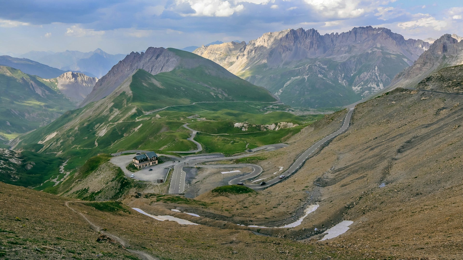
The French Alps don’t mess around. Col du Galibier sits at 8,678 feet, connecting the valleys of Maurienne and Briançon, and it’s been humbling cyclists in the Tour de France since 1911.
The pass opens only from June to October — winter seals it shut with snow that would bury a house.
The road spirals upward through terrain that looks borrowed from another planet. Barren slopes stretch toward peaks that scrape 13,000 feet, and the air gets thin enough that every breath feels deliberate.
At the summit, a monument to Henri Desgrange (founder of the Tour de France) stands against winds that never seem to stop.
Furka Pass
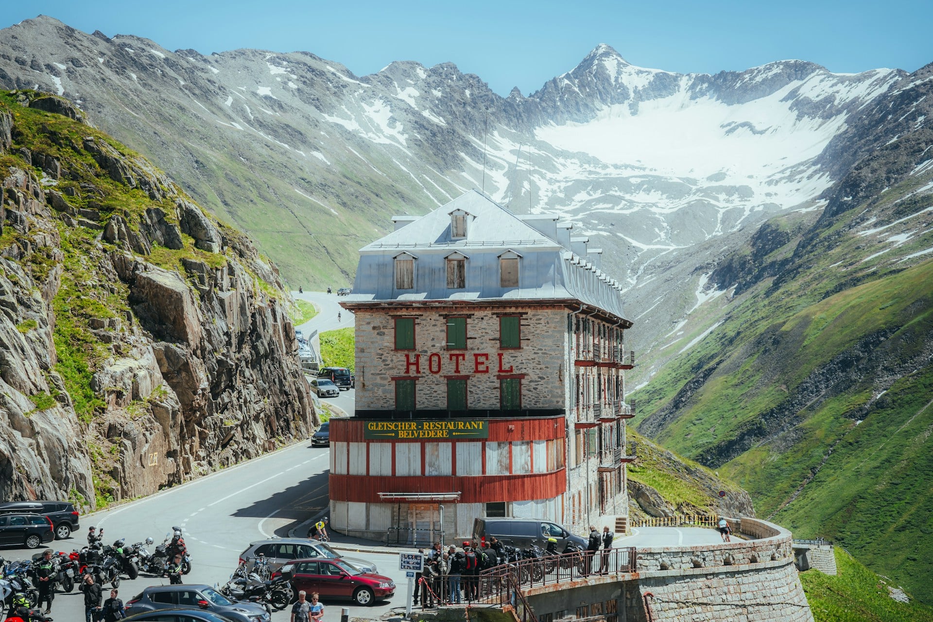
Switzerland’s Furka Pass earned its fame the hard way — by appearing in a James Bond film where Aston Martins navigate hairpin turns above deadly drops.
But long before Hollywood discovered it, this 7,992-foot crossing between the cantons of Uri and Valais was testing travelers’ nerves and rewarding them with views of the Rhône Glacier.
The pass closes each winter (typically October through May), which means the road becomes a seasonal pilgrimage site for drivers who appreciate the combination of terror and beauty that comes with navigating 36 numbered hairpin bends.
The old Furka Steam Railway still operates in summer, offering a slightly less death-defying way to cross the same terrain.
Transfagarasan Highway
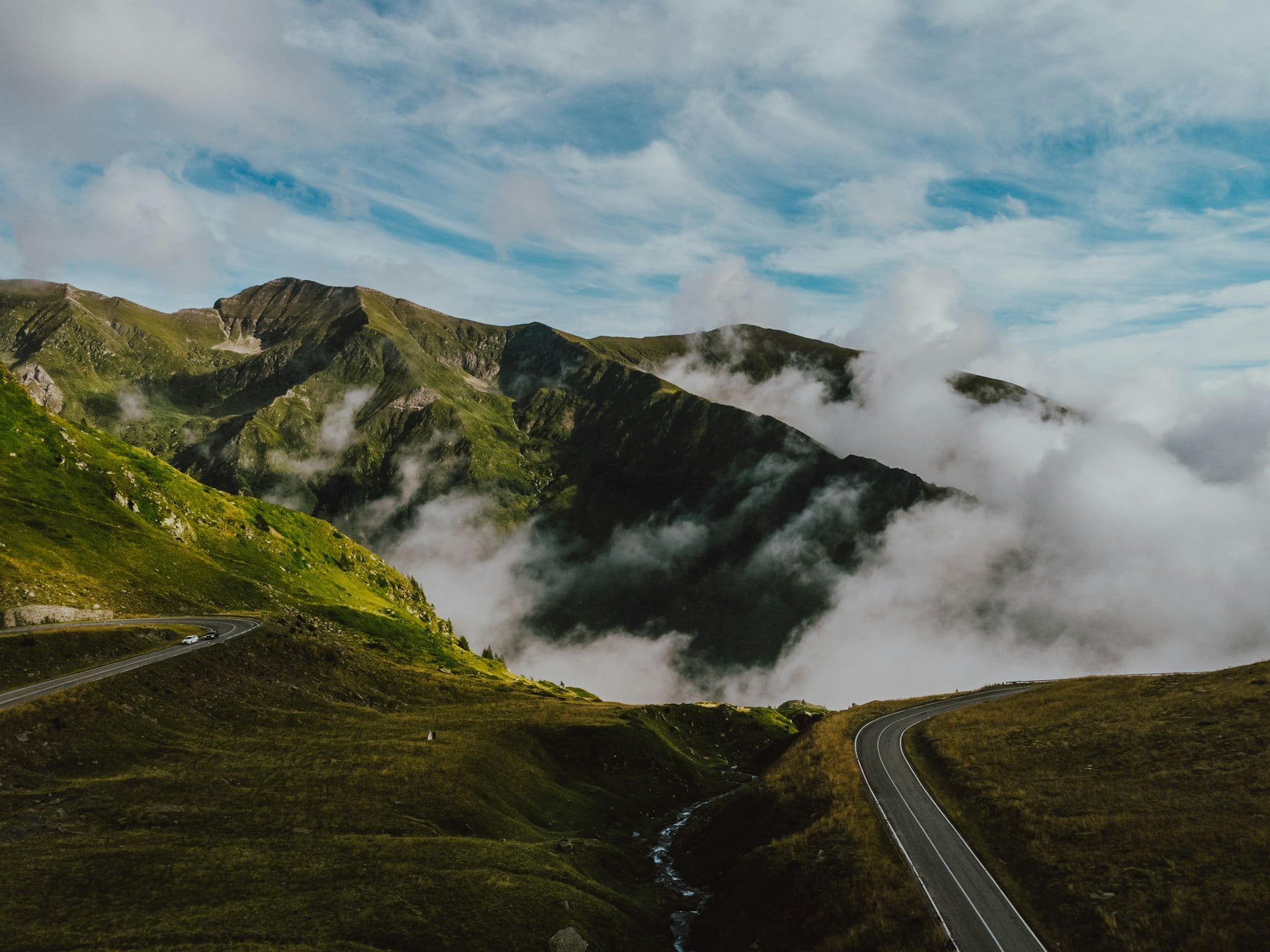
Romania’s Transfagarasan cuts through the Fagaras Mountains like something carved by giants with too much time on their hands.
Built in the 1970s as a military route (Ceaușescu wanted a way to move troops quickly across the Carpathians), this road now serves as one of Europe’s most dramatic driving experiences, though it opens only from July through October.
And yet the engineering feels almost defiant — 90 kilometers of switchbacks, tunnels, and bridges that climb to 6,699 feet at Balea Lake, where the landscape turns into something between Alpine meadow and lunar surface.
The road doesn’t just cross the mountains; it seems to argue with them, every curve a refutation of the idea that some places are meant to stay untouched. But then you reach the top, where glacial lakes reflect peaks that have been here since before humans had words for beauty, and the argument resolves itself into something like harmony.
Sella Pass
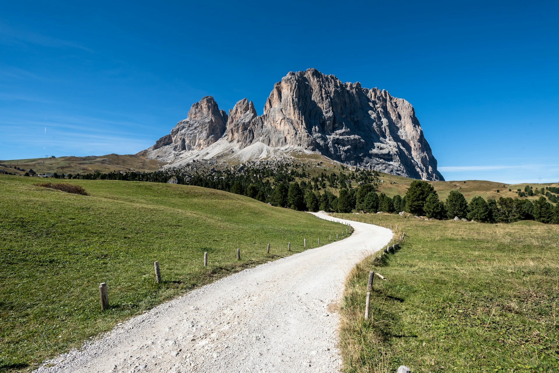
The Dolomites operate by their own rules of beauty, and Sella Pass proves it.
At 7,349 feet, this crossing connects four valleys in northern Italy’s South Tyrol region, staying open year-round thanks to modern snow removal that keeps the route clear even when the surrounding peaks disappear into winter clouds.
What makes Sella Pass remarkable isn’t just the altitude — it’s the geological theater.
The road circles the Sella massif, a limestone plateau that rises like a fortress from the valley floor. Each turn reveals new formations: vertical walls that glow pink at sunrise, meadows that explode with wildflowers in late spring, and views across to peaks with names like Marmolada and Sassolungo that sound like incantations.
The pass stays busy with cyclists, motorcyclists, and drivers who return year after year.
Which makes sense — some landscapes correct you each time you see them, showing you details that weren’t there before, or maybe just weren’t visible until your eyes learned how to look.
Khardung La
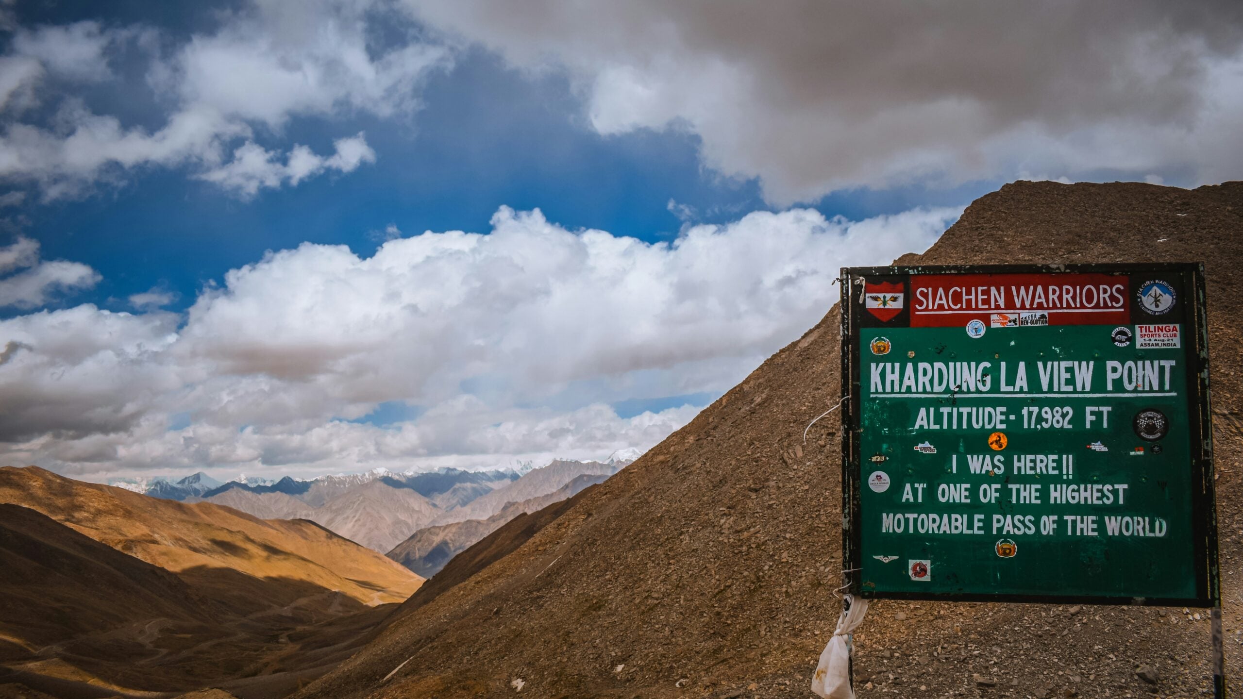
Ladakh’s Khardung La sits at 17,582 feet, making it one of the highest motorable passes on Earth.
Located north of Leh in India’s far northern region, this crossing leads to the Nubra Valley and serves as a supply route to some of the world’s most remote military outposts. The altitude here doesn’t just thin the air — it changes everything about how the human body functions.
Prayer flags snap in wind that carries snow even in summer.
The landscape looks scraped clean, all brown mountains and empty sky that stretches until it meets peaks so distant they seem theoretical. Travelers stop frequently, not just for photos but because breathing becomes something that requires attention.
The pass stays open most of the year, though winter crossings demand chains, patience, and a healthy respect for weather that can turn lethal without warning.
Going-To-The-Sun Road

Montana’s Going-to-the-Sun Road crosses the Continental Divide at Logan Pass, 6,646 feet up in Glacier National Park.
The road took 11 years to build, completed in 1932, and it shows what happens when engineering meets wilderness on wilderness’s terms. The route spans 50 miles from West Glacier to St. Mary, but Logan Pass represents the heart of the journey.
Here’s where North America’s backbone becomes visible.
Mountain goats wander the alpine meadows like they own the place, which they do. Glacial lakes reflect peaks that still carry snow in July. The landscape operates on a scale that makes human presence feel temporary — which, geologically speaking, it is.
The pass closes to through traffic from roughly October to June, depending on snowpack.
When it opens, the road becomes a pilgrimage route for anyone who wants to see what the continent looked like before we got here.
Gotthard Pass
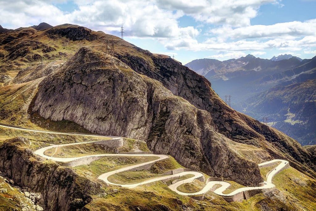
Switzerland’s Gotthard Pass carries more history per square mile than most countries.
At 6,909 feet, this crossing between the cantons of Uri and Ticino has been connecting northern and southern Europe since the 13th century. The old cobblestone road still exists, running parallel to the modern highway, and walking on stones worn smooth by centuries of traffic feels like touching the continent’s memory.
The pass doesn’t just cross the Alps — it defines them.
To the north, Germanic architecture and pine forests; to the south, Italian influences and Mediterranean vegetation. Weather changes with the geography, often dramatically. Clear skies on one side of the summit, rain on the other.
The Gotthard tunnel now carries most traffic, but the pass road remains open year-round, maintained by crews who understand that some routes matter beyond their practical function.
This crossing built trade relationships, decided battles, and shaped the character of modern Switzerland.
Stelvio Pass

Italy’s Stelvio Pass doesn’t apologize for its difficulty.
At 9,045 feet in the Eastern Alps, this crossing between Lombardy and South Tyrol features 48 numbered hairpin bends on the north side alone — each turn tight enough to make experienced drivers reach for the brake pedal with something approaching respect.
The pass opens typically from May through October, weather permitting, and during those months it becomes a proving ground for cyclists who want to test themselves against one of Europe’s most challenging climbs.
The gradient averages 7.4% but kicks steeper in sections that feel designed to break spirits.
But the suffering comes with compensation.
Views stretch across peaks that touch four countries. Alpine meadows bloom with flowers that exist nowhere else on Earth. And there’s something satisfying about reaching a summit that demands genuine effort — the kind of satisfaction that can’t be purchased, only earned.
Milford Road
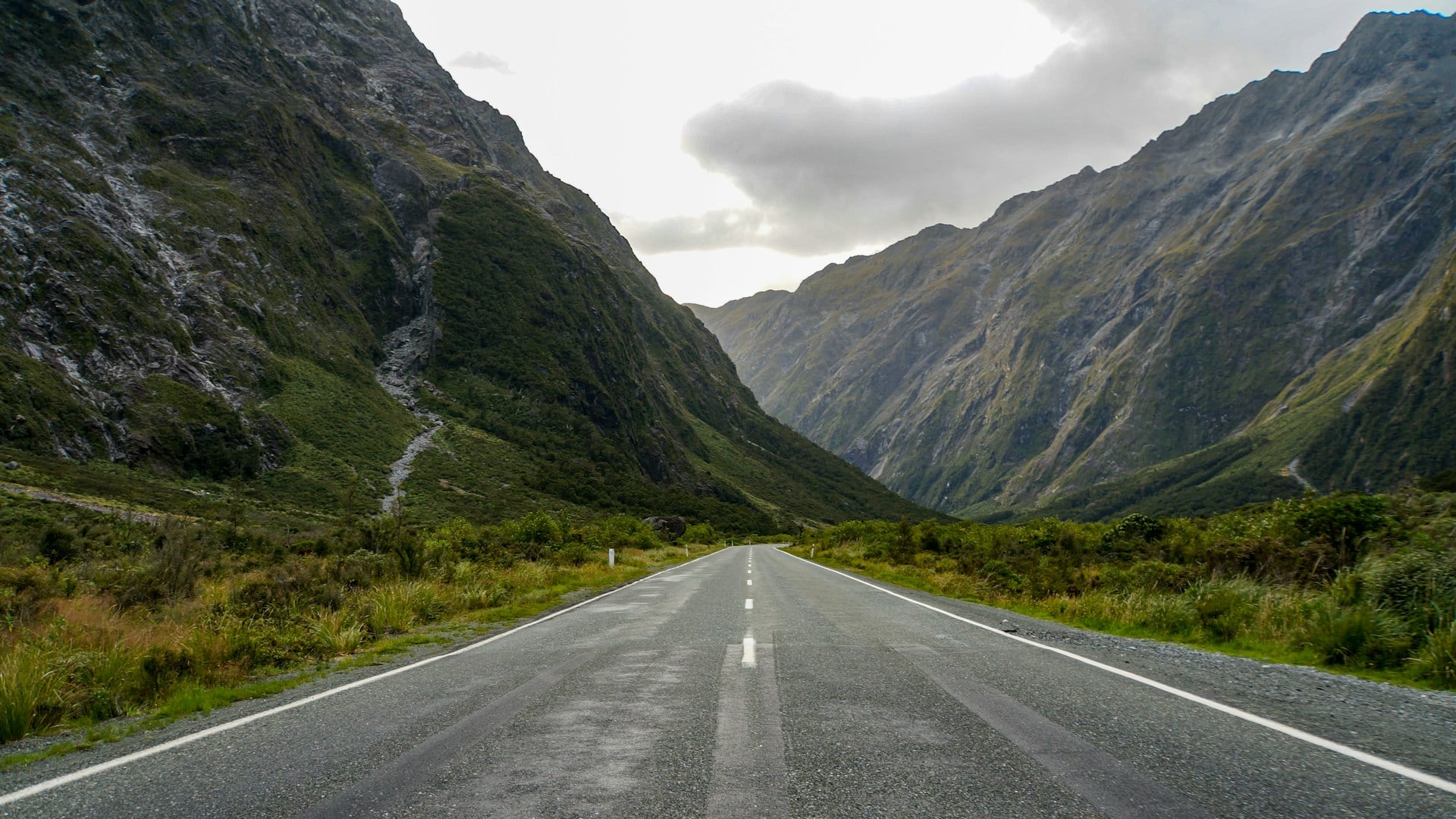
New Zealand’s Milford Road (State Highway 94) crosses the Southern Alps through Homer Tunnel, reaching its highest point at 945 meters before descending into Milford Sound.
The road doesn’t achieve the elevation of other passes on this list, but it compensates with scenery that feels borrowed from mythology.
The landscape here operates by different rules.
Waterfalls appear and disappear based on rainfall that can go from drizzle to deluge in minutes. Mountains rise directly from sea level to heights that scrape the clouds, their slopes too steep for human habitation. Fiordland National Park protects this terrain, ensuring it remains as untouched as any place accessible by road can be.
The route stays open year-round, though winter requires chains and avalanche warnings are taken seriously.
The road dead-ends at Milford Sound, which means every vehicle that drives in must drive back out — but most travelers find the return journey reveals entirely new views of the same landscape.
Karakoram Highway
The Karakoram Highway climbs to 15,397 feet at Khunjerab Pass, connecting Pakistan and China through terrain that tests both vehicles and human endurance.
Built jointly by Pakistani and Chinese workers over 20 years, this route crosses some of the world’s most challenging geography, where landslides and avalanches regularly reshape the road itself.
The pass represents more than an engineering achievement — it’s a monument to stubbornness.
The landscape actively resists human presence. Weather shifts without warning. Altitude sickness strikes even experienced travelers. Yet the road remains open most of the year, maintained by crews who rebuild sections that disappear beneath rockslides or washouts.
At Khunjerab Pass, glacial peaks of the Karakoram Range stretch in every direction, including K2, the world’s second-highest mountain.
The silence up there feels absolute, broken only by wind and the occasional truck carrying goods between civilizations separated by some of Earth’s most formidable barriers.
Grossglockner High Alpine Road

Austria’s Grossglockner High Alpine Road reaches 8,215 feet at Hochtor, the highest point along this 30-mile route through Hohe Tauern National Park.
Built in the 1930s as much for tourism as transportation, the road provides access to views of Austria’s highest peak, Grossglockner, and the largest glacier in the Eastern Alps, Pasterze Glacier.
The road closes from November through April, but during its open season it becomes a destination that justifies the toll fee.
The route includes visitor centers, exhibition areas, and viewpoints designed to help travelers understand the alpine environment they’re crossing. This isn’t just a road — it’s an education in high-altitude ecology and geology.
Alpine flowers bloom in meadows that remain snow-covered eight months of the year.
Marmots emerge from burrows to sun themselves on rocks. The landscape teaches patience — everything here grows slowly, blooms briefly, and endures conditions that would kill most life forms.
Beartooth Pass

Montana and Wyoming share Beartooth Pass, which tops out at 10,947 feet, making it the highest elevation highway in the northern Rocky Mountains.
The pass connects Red Lodge, Montana, to the northeast entrance of Yellowstone National Park, crossing terrain that remains above treeline for miles.
The road opens typically from late May through mid-October, depending on snowpack that can reach 15 feet deep.
When it’s open, Beartooth Pass offers driving through landscape that feels like the roof of North America. Glacial lakes reflect peaks that scrape 12,000 feet. Wildlife includes mountain goats, bighorn sheep, and grizzly bears that treat the road as just another feature of their territory.
Charles Kuralt called this “the most beautiful drive in America,” and the description sticks because it captures something about terrain that operates beyond human scales of beauty — landscape so vast and uncompromising that it changes how you think about your place in the world.
Col De La Bonette

France’s Col de la Bonette reaches 9,193 feet, making it one of Europe’s highest paved passes.
Located in the Maritime Alps near the Italian border, this crossing connects the valleys of Ubaye and Tinée through terrain that looks more like Tibet than Western Europe.
So this isn’t just about altitude — though the air gets thin enough that every breath feels deliberate.
It’s about the complete transformation of landscape that happens as the road climbs. Pine forests give way to alpine meadows, which surrender to bare rock and permanent snowfields. The final approach to the summit crosses terrain so barren it could serve as a stand-in for another planet. And yet there’s life here: flowers that bloom for six weeks a year, insects that survive temperatures that would freeze water solid, birds that nest at elevations where most creatures can’t even breathe properly.
The pass closes from November through May, sealed shut by snow that would bury houses.
But during its brief open season, Col de la Bonette offers access to views across peaks that stretch to the Mediterranean — on clear days, you can see both the highest mountains in Western Europe and the sea that defines the region’s southern boundary.
Where Roads Meet Sky

These passes represent more than convenient ways to cross mountain ranges.
They’re places where human ambition meets geological reality, where engineering bends to forces that have been shaping continents since before life crawled out of ancient seas. Each crossing tells a story about why people refuse to let mountains isolate them from what lies on the other side, and each offers views that justify whatever effort it took to get there.
The photographs capture moments, but the experience of standing at these elevations — breathing thin air, feeling weather that changes by the minute, seeing landscapes that stretch beyond the horizon — that stays with you long after the camera goes back in the bag.
More from Go2Tutors!

- The Romanov Crown Jewels and Their Tragic Fate
- 13 Historical Mysteries That Science Still Can’t Solve
- Famous Hoaxes That Fooled the World for Years
- 15 Child Stars with Tragic Adult Lives
- 16 Famous Jewelry Pieces in History
Like Go2Tutors’s content? Follow us on MSN.