Underground Waterfalls With Unbelievable Origins
Most people think of waterfalls as outdoor attractions—dramatic cascades tumbling down mountainsides or tropical plunges surrounded by lush vegetation. But some of the most remarkable waterfalls exist underground, hidden in caves and caverns where they’ve been flowing for millennia.
Their origins range from geological accidents to human engineering mistakes, and their stories reveal how water shapes the world in ways we rarely see.
Ruby Falls and the Sealed Cave

Ruby Falls in Tennessee exists because of intentional exploration. In 1905, a company building a railroad tunnel accidentally destroyed the natural entrance to a cave system.
The cave was sealed off and forgotten. In 1928, chemist and cave enthusiast Leo Lambert was drilling an elevator shaft for a different cave attraction when his drill broke through into the sealed cavern.
Lambert explored the newly accessible space and discovered a 145-foot underground waterfall. He named it after his wife, Ruby, and opened it to tourists in 1929.
The waterfall had been flowing in complete darkness since the natural entrance was destroyed in 1905, though it had existed for millions of years before that. Without Lambert’s intentional drilling, it might still be inaccessible today.
The waterfall itself forms from rainwater that seeps through limestone above. The water collects in underground streams and eventually reaches the precipice where it drops into a pool below.
The cave’s colorful rock formations and the dramatic lighting installed for tourists make it one of the most visited underground waterfalls in the United States.
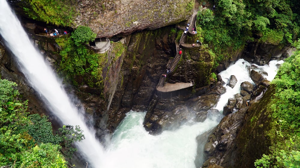
Trümmelbach Falls and the Glacial Grinder
Inside a mountain in Switzerland, ten waterfalls drain the meltwater from three massive glaciers. Trümmelbach Falls carries up to 20,000 liters of water per second during peak melt season—roughly 5,300 gallons.
The force is so intense that the mountain physically vibrates. The waterfalls formed through a process called glacial erosion.
For thousands of years, glaciers ground down the rock, creating channels and fissures. As the glaciers melted, water found these pathways and carved them deeper.
The limestone proved soft enough to erode but strong enough to maintain tunnel structures. What makes Trümmelbach unusual is its accessibility.
Most underground glacier-fed waterfalls are impossible to reach safely. But in 1913, engineers installed tunnels, walkways, and lighting systems that let visitors walk through the mountain and experience the falls up close.
The roar inside is deafening. The spray soaks everything.
Standing next to millions of gallons of fast-moving water inside solid rock creates a visceral reminder of nature’s power.
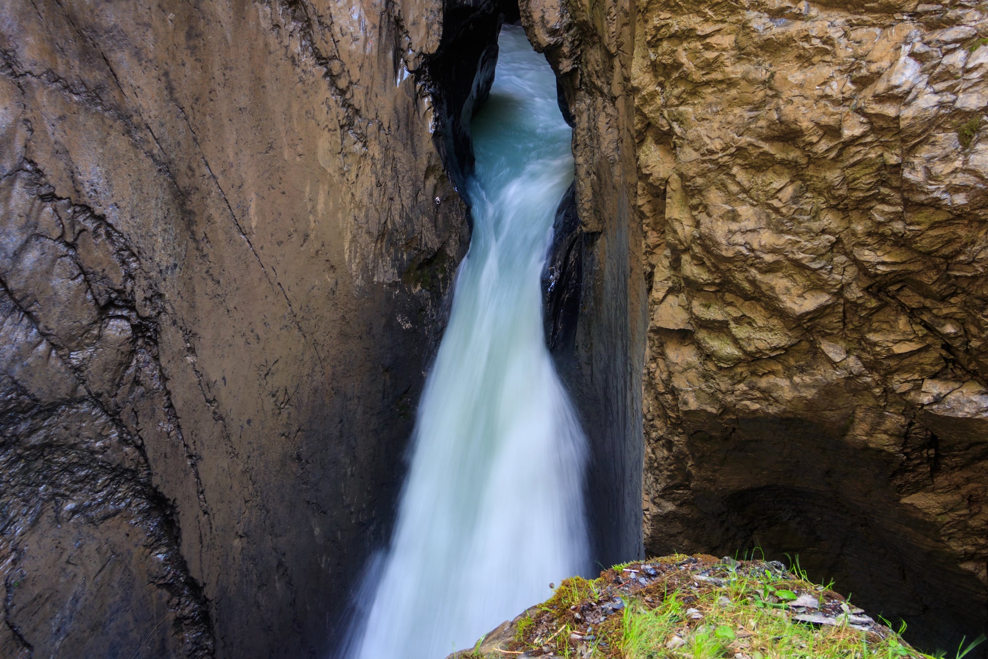
Cascata del Varone and the Eroded Grotto

Near Lake Garda in Italy, a waterfall drops into a grotto carved by rapid erosion. The Cascata del Varone formed over approximately 20,000 years as water cut through the limestone, creating a partially enclosed space.
The water now plunges 98 meters through openings in the rock. The grotto developed through continuous water action.
Rather than a sudden collapse, the limestone eroded gradually as water exploited weaknesses in the rock. The process created the current cave-like structure with openings above.
The erosion continues today at a geological pace—too slow to observe but constant enough that the cave’s shape changes over centuries. Visitors access the falls through two separate grottos, one lower and one upper, connected by pathways carved into the rock in the late 1800s.
The lower grotto puts you at the base of the falls, where mist fills the air and moss covers every surface. The upper grotto offers views from above, looking down through the opening where water disappears into darkness.
Gaping Gill and the Surface Stream Disappearance
In the Yorkshire Dales of England, a surface stream simply vanishes into the earth. Fell Beck flows across moorland until it reaches a sinkhole and drops 98 meters straight down—roughly the height of a 30-story building.
This creates Gaping Gill, Britain’s largest underground waterfall. The sinkhole formed through dissolution.
Rainwater, which is slightly acidic, dissolved the limestone over millions of years, creating a vertical shaft. The stream followed the path of least resistance, eventually cutting the dramatic drop that exists today.
Underground, the water continues through a vast cave system before emerging miles away. Access to Gaping Gill is restricted because of the danger.
Twice a year, caving clubs set up a winch system that lowers visitors into the main chamber. The descent takes several minutes, hanging in open air as water crashes beside you.
The chamber at the bottom is large enough to hold an entire cathedral.
Baatara Gorge Waterfall and the Triple Bridge
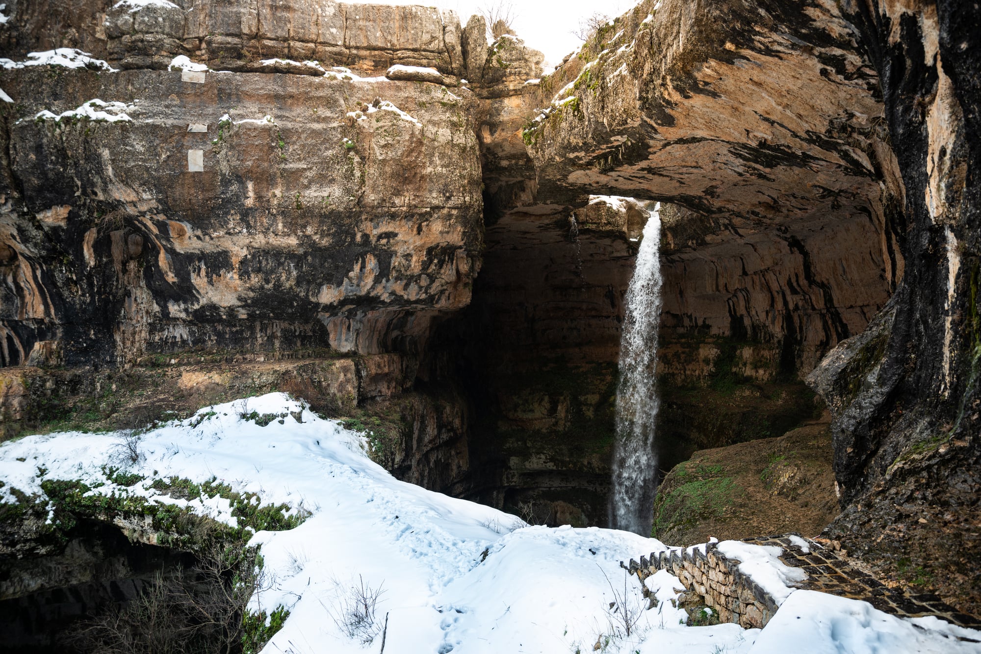
In Lebanon, a waterfall drops through three natural bridges stacked on top of each other. The Baatara Gorge Waterfall, also called the Cave of the Three Bridges, plunges 255 meters through this geological oddity into a cave below.
The bridges formed through a specific type of erosion. Water carved out the cave in Jurassic limestone that dates back 160 million years, creating a sinkhole at the surface in much more recent geological time.
As the cave ceiling eroded, it left behind three layers of rock that span the opening. The waterfall now drops through the center, passing through all three bridges before reaching the bottom.
The sinkhole and bridge formation is geologically young compared to the rock itself. The bridges won’t last forever.
Erosion continues to weaken them, and eventually they’ll collapse, changing the waterfall’s character entirely. For now, they create one of the most photogenic underground waterfalls in the world.
Skocjan Caves and the River That Vanished
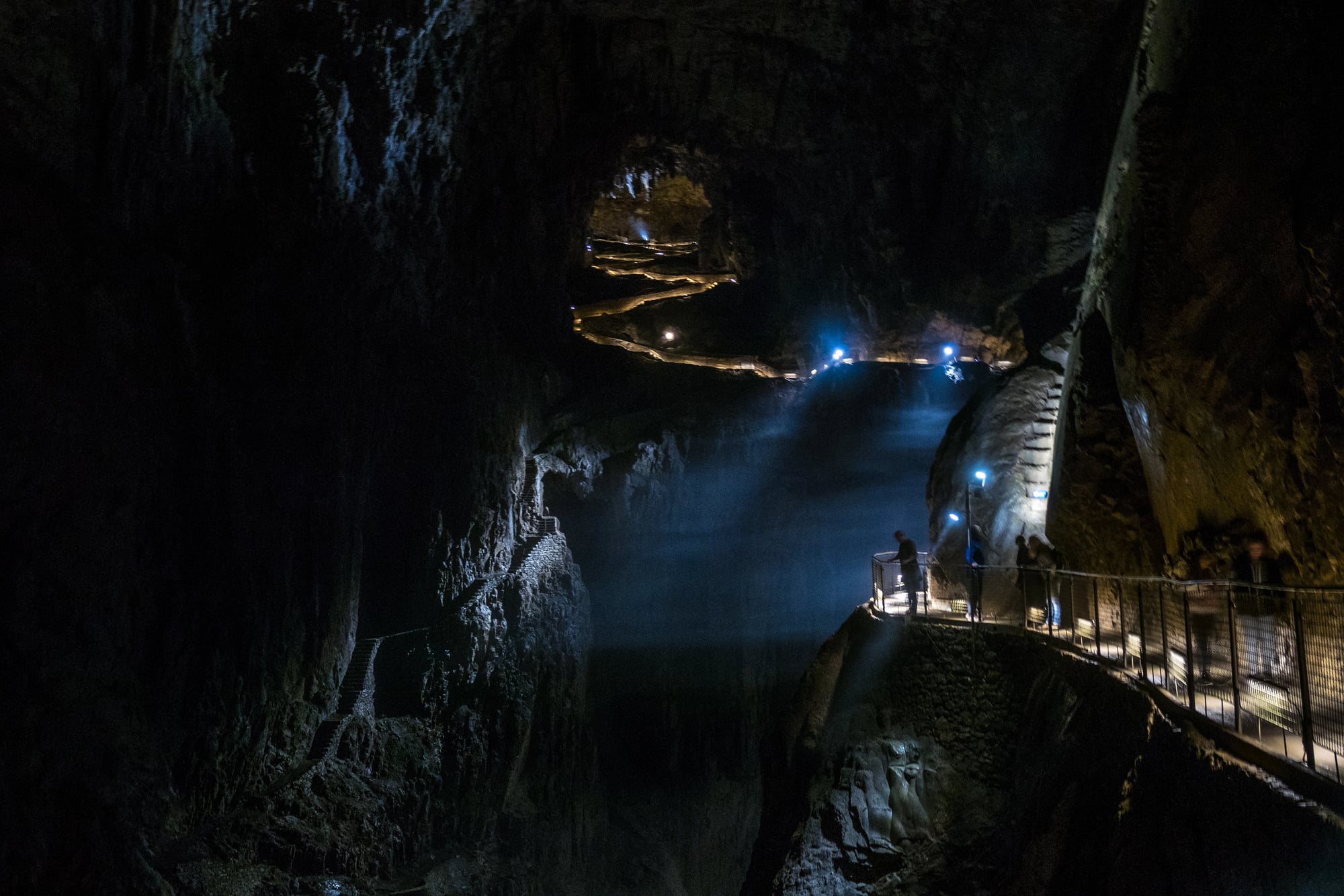
The Reka River in Slovenia flows above ground for miles, then suddenly disappears into a cave system. Inside the Skocjan Caves, the river creates multiple waterfalls as it drops through chambers carved over millions of years.
The underground section within the Skocjan system stretches for over 6 kilometers before continuing through other caves, with the river eventually emerging at the surface again after a total underground journey of about 34 kilometers. The cave system formed at the junction of two types of rock—limestone and non-permeable flysch.
Water couldn’t penetrate the flysch, so it carved through the softer limestone instead, creating the massive chambers. The waterfalls inside represent points where the riverbed drops suddenly, often where harder rock resisted erosion.
The caves became a UNESCO World Heritage Site partly because of their size and partly because of what they reveal about karst topography—landscapes formed by dissolving bedrock. The underground waterfalls provide a living example of ongoing geological processes.
Scientists study them to understand how similar formations developed elsewhere.
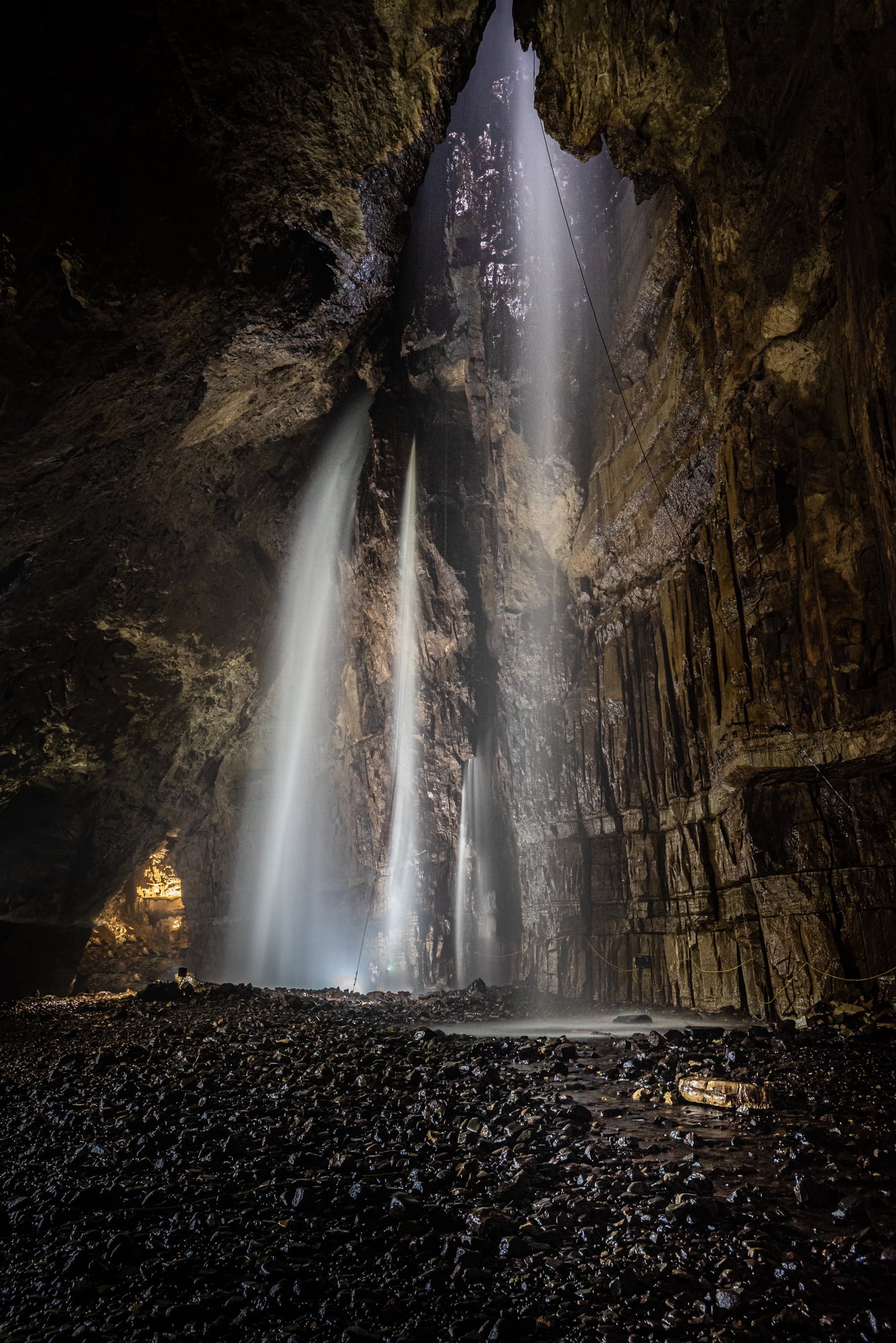
Lamprechtsofen Cave and the Vertical River
In the Austrian Alps, water flows almost vertically through one of the world’s deepest caves. The Lamprechtsofen system extends 1,632 meters deep—over a mile straight down.
Multiple waterfalls mark the descent as water drops through shafts and chambers, though most of these dramatic cascades exist in the deep technical sections of the cave. The cave formed along a geological fault line where the rock was already fractured.
Water exploited these weaknesses, carving deeper over time. The vertical nature of the waterfalls comes from the steep angle of the rock layers.
Instead of flowing horizontally and occasionally dropping, the water maintains a nearly vertical path for much of its journey. The lower sections of Lamprechtsofen are accessible to tourists via guided tours, but these areas show only the beginning of the cave system.
Reaching the deeper waterfalls demands ropes, harnesses, and considerable technical caving experience. The cold is intense—temperatures near freezing year-round—and the water flow varies dramatically with seasonal melt from the mountains above.
Río Secreto and the Ancient Cave System

Mexico’s Yucatán Peninsula is riddled with cenotes—sinkholes that connect to underground rivers. One of these systems, Río Secreto, contains waterfalls that flow between flooded chambers.
The cave system formed primarily during periods of lower sea levels during ice ages when more of the limestone was exposed to erosion. As sea levels rose and fell over millennia, different sections of the cave were alternately flooded and dry.
Where the cave floor drops suddenly, underground waterfalls formed. These aren’t dramatic plunges like surface waterfalls—the drops range from a few feet to about 30 feet—but they create constant sound and movement in otherwise still caverns.
The Maya civilization knew about these caves and considered them sacred portals to the underworld. Archaeological evidence suggests they performed ceremonies in the chambers, leaving pottery and other artifacts.
The waterfalls would have provided fresh water and marked significant points in the subterranean landscape.
Devil’s Kettle and the Unsolved Mystery

In Minnesota’s Judge C. R. Magney State Park, the Brule River splits around a rock outcropping. One side continues downstream normally.
The other side plunges into a pothole and disappears. For decades, nobody knew where the water went.
Scientists tried everything to solve the mystery. They poured dye into the pothole, expecting it to emerge downstream.
It didn’t. They dropped GPS trackers into the opening.
The devices were never recovered. They measured the river flow above and below the falls, finding that the volume downstream matched the entire river—suggesting the missing water rejoined somewhere.
Recent research using more sophisticated measurement techniques confirmed that the water does rejoin the main river immediately, flowing through underwater passages in the rock just below the surface. The waterfall itself continues to flow into the pothole, creating an underground cascade that remains largely invisible but much less mysterious than previously believed.
Mammoth Cave’s Hidden Streams

Kentucky’s Mammoth Cave system, the longest cave system in the world, contains a formation called Frozen Niagara—a flowstone cascade that mimics a frozen waterfall. But this isn’t an actual waterfall.
The real flowing waterfalls exist in the lower active stream passages of the cave, far from the tourist areas. These waterfalls formed as the Green River cut down through limestone layers.
As the river lowered its elevation over millions of years, caves that were once at river level became higher and drier. Underground streams continued flowing through the upper levels, eventually encountering drop-offs where they plunge to lower passages.
The cave system continues to evolve. New passages form as water finds new routes through the rock.
Old waterfalls dry up as streams change course. Mammoth Cave demonstrates that underground waterfalls aren’t static features—they’re temporary stages in ongoing geological processes.
Castellana Caves and the White Formations
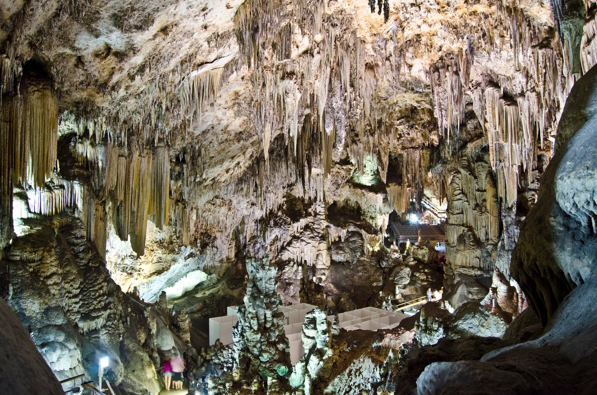
In southern Italy, the Castellana Caves contain stunning white calcite formations, including flowstone cascades that resemble frozen waterfalls. The contrast between these formations and the brilliant white rock creates an almost otherworldly appearance.
The cave system extends about 3 kilometers with a depth of 122 meters. The flowstone formations developed where water slowly deposited minerals over thousands of years.
The white color comes from the pure calcite deposits—essentially limestone that has been dissolved and redeposited in crystalline form. The process takes millennia, building the formations millimeter by millimeter.
The caves were unknown until 1938 when speleologist Franco Anelli descended through a surface opening to explore what he thought was a small cave. Instead, he discovered a massive system with multiple chambers, each containing unique formations.
The location deep in the system meant these features had formed in complete darkness until artificial lighting was installed.
Choranche Caves and the Emerald Pool

In the Vercors Mountains of France, a waterfall drops into a pool so clear and still that it appears emerald green. The Choranche Caves contain this unusual feature along with thousands of delicate stalactites called “fistuleuses” that hang from the ceiling like drinking straws.
The waterfall’s origin involves complex hydrology. Rainwater percolates through the mountains, collecting in underground aquifers.
When the water reaches impermeable rock layers, it flows laterally until finding vertical passages. The waterfall marks one of these passages, where water drops from an upper aquifer to a lower one.
The emerald color comes primarily from micro-algae that thrive in the cave’s specific conditions, along with dissolved limestone minerals in the water. The pool is so clear that visibility extends meters down, revealing the continuation of the cave system below the surface.
The pool’s stillness suggests the water flows out through underwater passages rather than a visible outlet.
Where Water Finds Its Way

Underground waterfalls exist at the intersection of geology, hydrology, and time. They form where water exploits weaknesses in rock, where layers of different hardness create sudden drops, where human activity accidentally breaches sealed systems.
Each one tells a story of how water shapes the hidden world beneath our feet. These waterfalls will continue changing.
Some will grow larger as erosion continues. Others will dry up as water finds new paths.
A few will be discovered for the first time, flowing in darkness until someone breaks through. Water always finds a way downward, and whenever it drops suddenly in the dark, it creates these hidden wonders that most people will never see.
More from Go2Tutors!

- The Romanov Crown Jewels and Their Tragic Fate
- 13 Historical Mysteries That Science Still Can’t Solve
- Famous Hoaxes That Fooled the World for Years
- 15 Child Stars with Tragic Adult Lives
- 16 Famous Jewelry Pieces in History
Like Go2Tutors’s content? Follow us on MSN.