Unusual Roads That Changed City Travel
Cities have always struggled with the same basic problem: how do you move people around safely without turning streets into dangerous, congested parking lots? For decades, the answer seemed simple—build more lanes, add more highways, make everything bigger. But some cities took a different approach.
They tried ideas that seemed strange, even risky. Some worked brilliantly.
Others flopped. And a few changed the way we think about roads entirely.
Here is a list of unusual roads and road designs that transformed urban transportation.
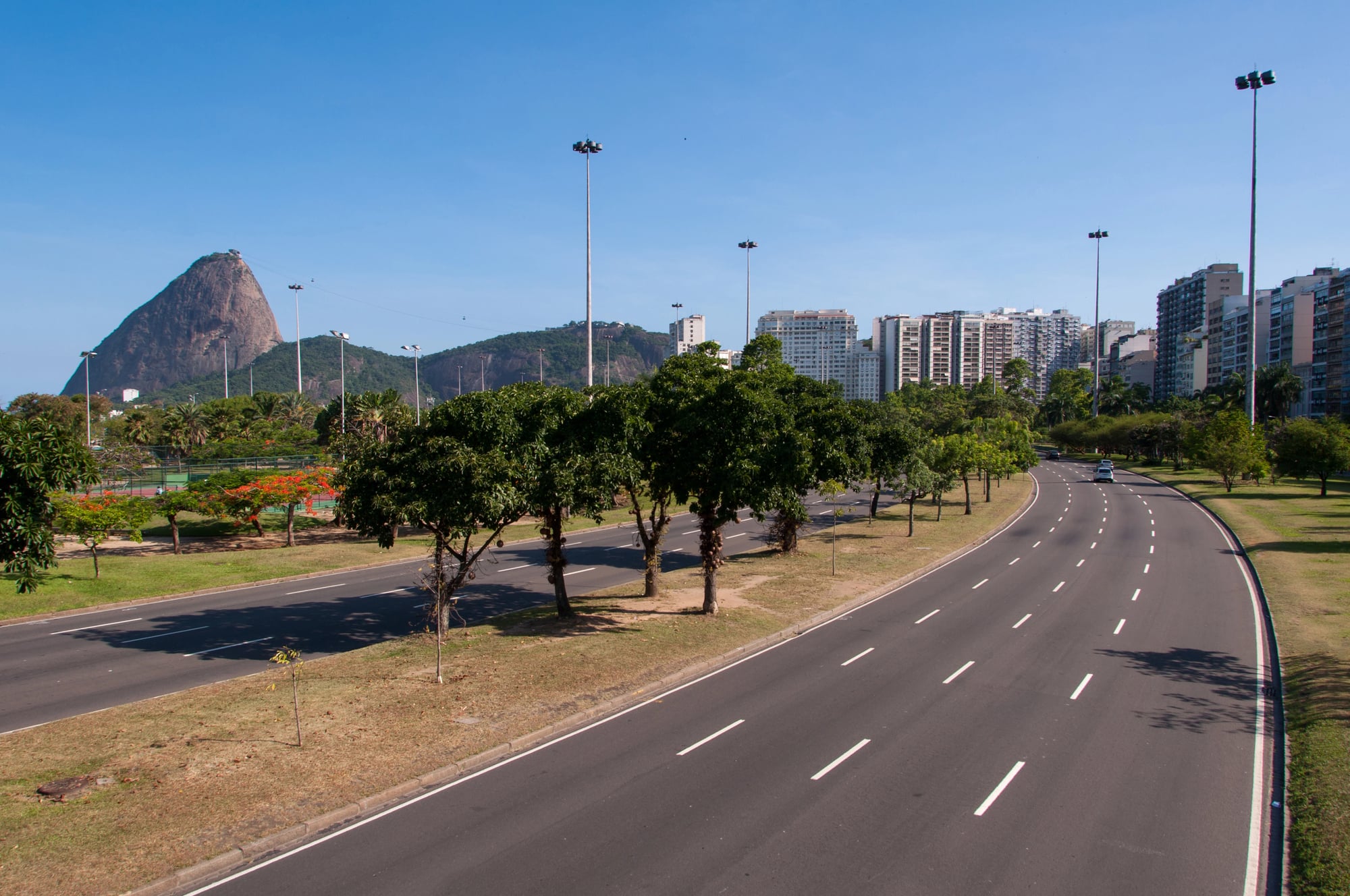
Cheonggyecheon Stream
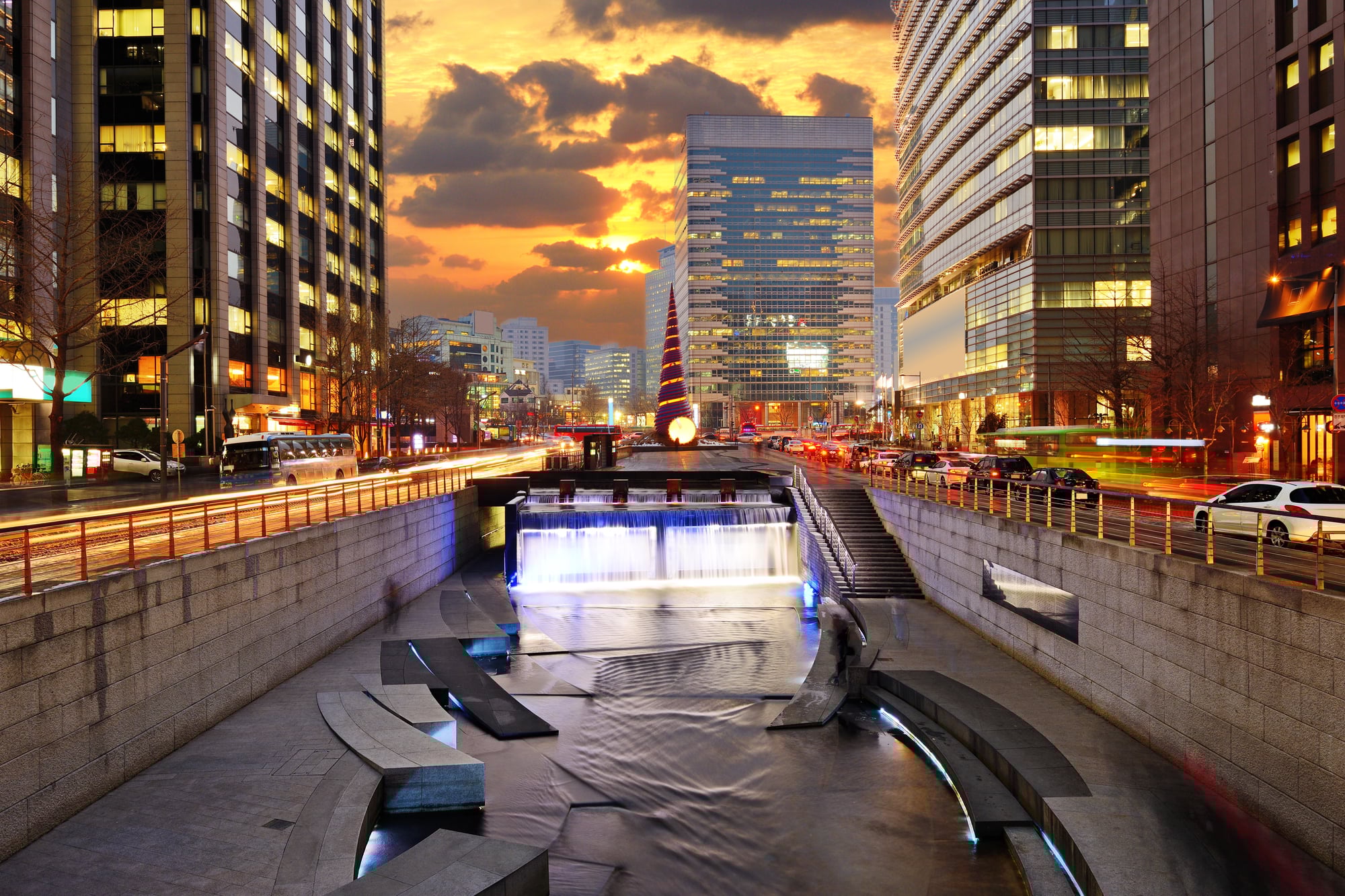
Seoul had an elevated highway running through its downtown for decades. Built in 1976, the six-lane structure carried more than 168,000 vehicles daily and divided the city’s north and south sides.
By 2003, the highway was crumbling and dangerous. Instead of rebuilding it, the city made a bold choice: they tore it down completely and restored the stream that had been buried underneath.
The project cost around $281 million and finished in 2005. Traffic didn’t get worse—it actually improved.
Bus ridership jumped 15 percent, subway use went up 3 percent, and the number of cars entering downtown dropped by 2 percent. The restored stream became a popular park, attracting 64,000 visitors daily.
Temperatures along the stream dropped by several degrees compared to nearby streets, and biodiversity increased dramatically—plant species went from 62 to 308, fish from 4 to 25. The success proved that removing highways sometimes works better than expanding them.
Big Dig
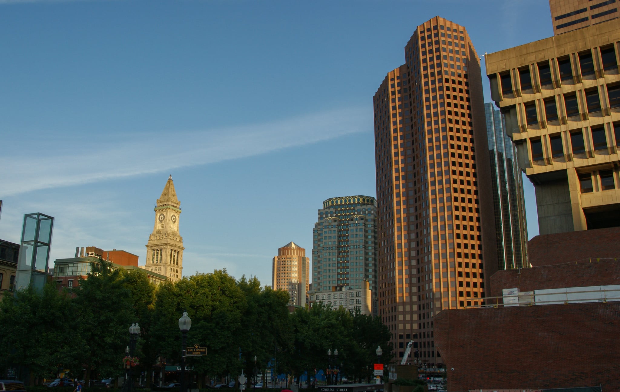
Boston’s Central Artery was a disaster. The elevated highway carried 200,000 vehicles daily through a route designed for 75,000.
Accident rates were four times the national average. In 1991, construction began on one of the most ambitious infrastructure projects in U.S. history: burying the highway underground.
The Big Dig replaced the elevated six-lane highway with an underground expressway featuring eight to ten lanes. It also built the Ted Williams Tunnel beneath Boston Harbor and the Leonard P. Zakim Bunker Hill Bridge, the widest cable-stayed bridge in the world.
The project took 15 years and cost over $14 billion. But it worked.
Travel times dropped by 62 percent between 1995 and 2003. The old elevated structure came down, and in its place, the city built the Rose Kennedy Greenway—a series of parks that reconnected neighborhoods torn apart decades earlier.
Diverging Diamond Interchanges

Traffic engineer Gilbert Chlewicki had an unusual idea: what if cars briefly drove on the left side of the road when crossing a highway? It sounds confusing, but the design eliminates the most dangerous conflict points at intersections.
At a typical diamond interchange, drivers making left turns have to cross oncoming traffic. The diverging diamond moves traffic to the opposite side of the road, so left turns become free-flowing.
Missouri built the first one in Springfield in 2009. Before the conversion, drivers sometimes waited 20 minutes to make a left turn.
After the change, backups disappeared almost immediately, and crashes dropped by 40 to 50 percent. The design caught on fast.
By 2025, more than 200 diverging diamond interchanges were operating across the United States in more than 30 states. They cost less to build than traditional interchanges and use less space, making them particularly attractive for congested urban areas.
Modern Roundabouts
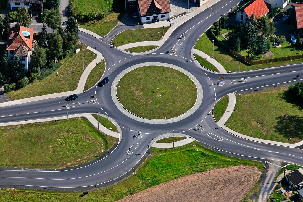
In 1966, the United Kingdom made a simple rule change at circular intersections: entering traffic must yield to traffic already in the circle. This shift created the modern roundabout.
Traffic flowed better—up to 10 percent improvement—and crashes dropped by 40 percent. Other countries noticed.
The U.S. built its first modern roundabout in Nevada in 1990. By 2015, the UK had around 25,000 roundabouts, and France had more than 30,000.
They reduce the types of crashes that kill and seriously injure people—right-angle, left-turn, and head-on collisions become nearly impossible. Pedestrians benefit too.
Crossing distances are shorter, and cars move slower than at signalized intersections. The design forces drivers to slow down naturally, without relying on stop signs or traffic lights.
Woonerf
In the late 1960s, residents of Delft, Netherlands, got fed up with speeding cars on their residential streets. Some took matters into their own hands and tore up pavement at night to create obstacles.
The government took notice and formalized the concept in 1976. A woonerf eliminates the traditional division between sidewalks and streets.
Pedestrians can walk anywhere. Cars are allowed, but they’re treated as guests.
Speed limits drop to 15 kilometers per hour (about 9 miles per hour). Street furniture, planters, and trees make it physically difficult to drive fast.
The design creates a shared space where children can play, neighbors can chat, and everyone moves more slowly. By 1999, the Netherlands had over 6,000 woonerf areas.
The concept spread to Belgium, Germany, and eventually to cities worldwide, influencing the broader shared streets movement.
Road Diets
The term sounds extreme, but road diets are straightforward: convert a four-lane undivided road into a three-lane road with two through lanes and a center turn lane. One of the first happened in Billings, Montana, in 1979.
The city converted 17th Street West from four lanes to three. Crashes dropped, and vehicle delay barely changed.
Research consistently shows crash reductions between 19 and 47 percent when road diets are implemented properly. They work best on roads carrying fewer than 20,000 vehicles per day.
San Francisco has completed over 40 road diet projects since the late 1970s. Valencia Street, converted in 1999, became a national model.
The extra space from eliminated lanes often gets repurposed for bike lanes, wider sidewalks, or on-street parking. Side streets benefit too—drivers crossing the main road only need to navigate three lanes instead of four.
Pedestrian Scrambles

Traffic engineer Henry Barnes popularized an idea that seemed radical in the 1940s: stop all cars at certain intersections and let pedestrians cross in every direction at once, even diagonally. Kansas City and Vancouver were among the first cities to try it.
The design became known as the Barnes Dance after a reporter wrote that Barnes ‘made people so happy they’re dancing in the streets.’ The concept fell out of favor for decades as traffic engineers prioritized car flow over pedestrian convenience.
But it made a comeback. Research from Transport for London suggested diagonal crossings reduced pedestrian casualties by 38 percent.
Tokyo’s Shibuya Crossing—the world’s busiest pedestrian scramble—can handle up to 3,000 people crossing simultaneously. New York had 635 intersections with exclusive pedestrian phases as of 2017.
Los Angeles started installing them to meet its Vision Zero goal of eliminating traffic deaths by 2035. At intersections where pedestrian volume is high and car traffic unavoidable, scrambles make sense.
Protected Bike Lanes

New York City Transportation Commissioner Janette Sadik-Khan built the Ninth Avenue protected bike lane in 2007. The design placed a physical barrier—often parked cars or concrete curbs—between cyclists and moving traffic.
It wasn’t a new concept in Europe, where cycle tracks had existed since the 1960s. But in the United States, protected lanes were rare until New York showed they worked.
Bike traffic on streets with protected lanes increased dramatically. Philadelphia, San Francisco, and Washington D.C. all saw 100 percent increases in cycling after installing protected lanes.
On New York’s Columbus Avenue, cycling jumped 56 percent while crashes decreased 34 percent. Importantly, injuries dropped not just for cyclists but for all road users.
Studies showed 28 percent fewer injuries per mile on streets with protected lanes compared to streets without bike infrastructure. Portland added one in 2009, followed by Washington’s Pennsylvania Avenue in 2010 and San Francisco’s Market Street the same year.
Raised Intersections

Raised intersections are essentially speed tables that cover entire intersections, including crosswalks. They force drivers to slow down naturally because hitting the raised surface at high speed is uncomfortable.
The design improves pedestrian safety by making people crossing the street more visible to drivers. The concept addresses two problems at once: speeding through intersections and low pedestrian visibility.
Because the raised section typically matches the height of adjacent sidewalks, curb cuts aren’t needed, making the crossing fully accessible. Emergency vehicles can still pass through—they just move more slowly.
The same principle applies with speed tables on single streets, which raise a section of roadway while keeping a flat top long enough to accommodate a vehicle’s wheelbase. Cities use them in school zones, residential areas, and anywhere pedestrian activity is high.
Plastic Roads

Rajagopalan Vasudevan developed a process in 2001 that mixed shredded plastic waste into asphalt. India became the first country to adopt the technology at scale.
Chennai started building roads with plastic-modified asphalt, and by recent counts, India had constructed over 700 kilometers of national highways using this method. The plastic roads proved as durable as traditional asphalt while solving a waste problem.
Plastic that would otherwise end up in landfills, rivers, or oceans gets incorporated into road surfaces. The material reduces the amount of bitumen needed, cutting costs and carbon emissions.
The roads handle wear and tear well and require less maintenance than conventional surfaces. Other countries took notice, and the technology began spreading beyond India to places dealing with both infrastructure needs and plastic waste problems.
Solar Roads

In 2014, France built the world’s first solar road in the village of Tourouvre au Perche in Normandy. Photovoltaic panels were installed directly into the road surface, generating electricity from passing sunlight.
The one-kilometer stretch was designed to power street lights in the village. The technology faced challenges.
The panels couldn’t generate as much power as rooftop solar because they had to be durable enough for vehicles to drive over them, which required thicker protective layers that reduced efficiency. They cost significantly more than traditional solar installations.
And roads don’t make ideal solar collectors—they accumulate dirt and shadows from vehicles. Despite the obstacles, the concept sparked interest in combining infrastructure with renewable energy generation.
Several other countries launched pilot projects to test whether solar roads could work economically at larger scales.
Harbor Drive Removal

Portland, Oregon, made history in 1974 by becoming the first U.S. city to remove a major highway for parkland. Harbor Drive, a four-lane highway built along the Willamette River, had cut off downtown from the waterfront.
City leaders decided the highway had to go. The removal created Tom McCall Waterfront Park, a 36-acre green space that reconnected the city with its river.
The Hawthorne Bridge, which had been part of the highway system, became a pedestrian and bicycle bridge. Traffic didn’t collapse.
Cars found other routes, and the city gained public space that became central to community life. The success inspired other cities to consider highway removal.
San Francisco would later remove the Embarcadero Freeway after the 1989 earthquake damaged it, creating similar benefits. Portland proved that highways aren’t permanent and that cities can change their minds about infrastructure choices.
High-Friction Surface Treatments

Some crashes happen simply because roads are too slippery, especially on curves or at stop points. High-friction surface treatments apply a special aggregate material with a polymer binder to the road surface, dramatically increasing traction.
The materials are particularly effective on curves where vehicles tend to skid. The Federal Highway Administration promoted these treatments as a proven safety countermeasure.
They’re most useful on roads where wet conditions or sharp curves create skidding risks. Washington state applied high-friction treatments to a curve in Bellevue and saw crash rates drop significantly.
The material costs more than regular asphalt, but cities typically reserve it for high-risk locations where the safety benefits justify the expense. Installation is relatively quick, and the treatments last several years before needing replacement.
The technology addresses a specific, dangerous problem with a straightforward engineering solution.
Glow-in-the-Dark Road Markings
Dutch designer Daan Roosegaarde created road lines that absorb sunlight during the day and glow at night, eliminating the need for streetlights. A stretch of road in the Netherlands tested the concept.
The fluorescent paint charges in daylight and emits light for up to ten hours after dark. The design offers an energy-efficient alternative to traditional street lighting, particularly on less-traveled roads.
Roosegaarde also developed temperature-sensitive paint that illuminates when temperatures drop, warning drivers about ice on the road ahead. The Netherlands implemented these innovations on small sections of road and bike paths.
While the technology hasn’t spread widely yet, it demonstrates how roads can become smarter without requiring complex electronics or ongoing power consumption. The simple physics of photoluminescence could make roads safer while reducing energy costs.
Avenida 9 de Julio

Buenos Aires transformed one of its most prominent streets in 2013. Avenida 9 de Julio—a massive multi-lane thoroughfare—was converted into a major public transit corridor.
The redesign prioritized buses and pedestrians over private vehicles. The transformation showed that even wide, car-dominated streets can change.
Where vehicles once dominated, bus rapid transit lanes now provide reliable public transportation. Sidewalks expanded, and pedestrian crossings improved.
The project was part of a broader movement in Latin American cities to reclaim street space from cars and allocate it to transit that serves more people more efficiently. The change required political will and faced resistance from drivers who lost road space.
But cities watching Buenos Aires saw that streets serving hundreds of thousands of people on buses make more sense than streets serving far fewer in private cars.
Complete Streets

Complete Streets isn’t a single road but a design philosophy that emerged in the early 2000s. The idea is simple: streets should work for everyone—drivers, cyclists, pedestrians, transit users, and people with disabilities.
Traditional street design focused almost exclusively on moving cars quickly. Complete Streets take a different approach.
The movement gained momentum when cities realized that car-only design created dangerous, unwelcoming environments for anyone not in a vehicle. A Complete Street might include bike lanes, wider sidewalks, pedestrian crossings, bus lanes, and trees—all on the same corridor.
New York, Virginia, and other states adopted ‘Complete Streets’ policies requiring these principles in road design. The approach represents a fundamental shift in how streets get designed, moving from single-purpose infrastructure to multi-use public space.
Streets aren’t just for cars anymore. They’re for everyone.
Roads That Recharge

Electric vehicles face a practical problem: limited range. Wireless charging roads offer a potential solution.
The technology uses electromagnetic coils buried beneath the road surface that transfer power to vehicles driving over them. Several countries have tested the concept.
Sweden built a test track where electric vehicles charge while moving. South Korea installed wireless charging on a bus route in Gumi.
The technology could extend vehicle range significantly—some estimates suggest that installing charging infrastructure on just 10 percent of major roads could increase electric vehicle range from around 60 miles to nearly 300 miles. The main obstacles are cost and standardization.
Embedding charging coils in roadways requires significant infrastructure investment, and manufacturers need to agree on technical standards. But the concept addresses a major barrier to electric vehicle adoption: range anxiety.
If cars can charge while driving, charging stations become less critical.
When Roads Become Places
The most unusual roads aren’t necessarily the ones with the most impressive engineering. Sometimes the unusual part is recognizing that roads serve purposes beyond moving vehicles.
Seoul removed a highway and got a park. Portland tore down Harbor Drive and reconnected with its waterfront.
The Netherlands created streets where children play safely while cars move slowly in the background. These changes took courage.
Highway removal sounds like a traffic disaster. Putting pedestrians and cars in the same space seems dangerous.
Telling drivers to share lanes with bikes feels controversial. But cities that took these risks often found that the fears didn’t materialize.
Traffic adapted. People adjusted.
And the benefits—safer streets, more livable neighborhoods, cleaner air—proved worth the initial discomfort. Roads shape cities, but cities can reshape roads when they stop accepting that things have to stay the way they’ve always been.
More from Go2Tutors!

- The Romanov Crown Jewels and Their Tragic Fate
- 13 Historical Mysteries That Science Still Can’t Solve
- Famous Hoaxes That Fooled the World for Years
- 15 Child Stars with Tragic Adult Lives
- 16 Famous Jewelry Pieces in History
Like Go2Tutors’s content? Follow us on MSN.