15 Cloud Formations That Predict Tomorrow’s Weather
Long before weather apps and meteorologists, people looked up at the sky to predict what tomorrow would bring. Clouds tell stories about atmospheric conditions, pressure changes, and weather patterns that are heading your way.
Here’s a list of 15 cloud formations that can help you predict tomorrow’s weather. Learning to read these natural forecasters can give you a warning about what’s coming, sometimes hours or even days ahead.
Cirrus Clouds

These thin, wispy clouds that look like paint strokes across the sky typically signal changing weather within 24 hours. They form at high altitudes where strong winds stretch ice crystals into delicate patterns.
When you see them thickening and spreading, it usually means a warm front is approaching with rain or snow following in a day or two.
Cumulus Clouds

Fair weather cumulus clouds look like fluffy cotton balls with flat bases and puffy tops, indicating stable atmospheric conditions. They form during sunny days when warm air rises and cools, creating these picture-perfect clouds.
If they stay small and scattered, expect continued pleasant weather for the next day or so.
Like Go2Tutors’s content? Follow us on MSN.
Cumulonimbus Clouds

These towering giants can reach heights of over 40,000 feet and signal immediate severe weather approaching. They’re the thunderstorm clouds that bring heavy rain, hail, lightning, and sometimes tornadoes within hours of forming.
When you spot their characteristic anvil-shaped tops, it’s time to head indoors because dangerous weather is imminent.
Altocumulus Clouds

These gray or white patches that appear in waves or bands across the middle sky often indicate thunderstorms later in the day. They form when there’s instability in the middle atmosphere, creating conditions ripe for afternoon or evening storms.
If you see them in the morning, there’s a good chance you’ll hear thunder before bedtime.
Altostratus Clouds

These gray or blue-gray sheets that cover the entire sky like a veil usually mean rain or snow is coming within 12 to 24 hours. They’re thick enough to dim the sun but thin enough that you can still make out its general position.
This type of overcast sky is often the advance guard of an approaching weather system.
Like Go2Tutors’s content? Follow us on MSN.
Cirrostratus Clouds

These thin, sheet-like clouds that cover the whole sky create a milky appearance and often produce halos around the sun or moon. They typically indicate that a warm front is approaching and rain will likely arrive within 24 to 48 hours.
The halo effect happens when light bends through ice crystals in these high-altitude clouds.
Nimbostratus Clouds

These thick, dark gray clouds that blanket the sky bring steady, continuous precipitation for several hours or even days. They form when warm, moist air gradually rises over cooler air, creating widespread overcast conditions.
When you see this uniform gray coverage, expect persistent but usually gentle rain or snow.
Stratocumulus Clouds

These low, lumpy gray clouds that spread across the sky in patches or layers rarely produce more than light rain or drizzle. They indicate stable but moist conditions in the lower atmosphere.
While they might look threatening, they typically clear up within a day and don’t bring severe weather.
Like Go2Tutors’s content? Follow us on MSN.
Mammatus Clouds
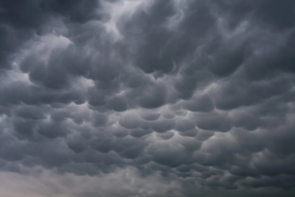
These unusual pouch-like formations that hang down from the cloud base like udders signal that severe weather has just passed or is nearby. They form when cold, dense air sinks down from the cloud, creating these distinctive bulges.
Seeing mammatus clouds means the atmosphere is extremely unstable, though the worst weather may have already moved through.
Lenticular Clouds
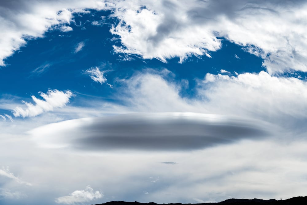
These smooth, lens-shaped clouds that form near mountains indicate strong winds aloft and potential turbulence. They develop when air flows over mountain peaks and creates standing waves in the atmosphere.
If you’re planning outdoor activities in mountainous areas, these clouds warn of gusty conditions and rapidly changing weather.
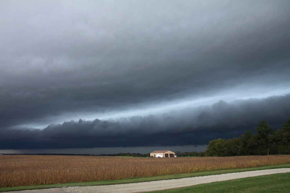
Shelf Clouds

These low, horizontal clouds that stretch across the horizon like a shelf mark the leading edge of a thunderstorm. They form where cool downdrafts from the storm meet warm surface air, creating a distinct boundary.
When you see a shelf cloud approaching, severe weather, including heavy rain, hail, and strong winds, will arrive within minutes.
Like Go2Tutors’s content? Follow us on MSN.
Roll Clouds

These rare, tube-shaped clouds that appear to roll horizontally across the sky indicate strong atmospheric disturbances. They form when cool air undercuts warm air, creating a rotating cylinder of cloud.
While spectacular to see, they often signal approaching severe weather or the aftermath of a powerful storm system.
Asperitas Clouds

These dramatic, wave-like clouds that appear to churn and roll overhead are relatively newly classified and indicate atmospheric turbulence. They form when different air masses with varying temperatures and humidity levels interact chaotically.
While they look ominous, they typically don’t produce severe weather but suggest unsettled atmospheric conditions.
Wall Clouds
These isolated, rotating lowerings that hang beneath the main storm cloud are a serious warning sign for tornado development. They form when warm, moist air gets drawn up into the storm while cool air sinks around it, creating rotation.
If you spot a wall cloud, take shelter immediately because tornado formation could happen within minutes.
Like Go2Tutors’s content? Follow us on MSN.
Pyrocumulus Clouds

These towering clouds that form above intense heat sources like wildfires indicate dangerous fire conditions and potential for rapid fire spread. They develop when extreme heat causes powerful updrafts that can create their own weather systems.
These clouds can produce lightning that starts new fires, making them particularly dangerous during fire season.
Nature’s Weather Station

These cloud formations have been helping humans predict weather for thousands of years, long before modern meteorology existed. Each type tells a specific story about atmospheric conditions and what’s likely to happen next.
While weather apps provide detailed forecasts, learning to read clouds gives you immediate, location-specific information that can help you make better decisions about outdoor activities and daily plans.
More from Go2Tutors!

- 16 Restaurant Chains That Went Too Fast
- 12 Things Sold in the 80s That Are Now Illegal
- 15 VHS Tapes That Could Be Worth Thousands
- 17 Historical “What Ifs” That Would Have Changed Everything
- 18 TV Shows That Vanished Without a Finale
Like Go2Tutors’s content? Follow us on MSN.