15 Geography Mistakes Most Americans Still Make
Geography can be tricky, and even well-educated Americans sometimes get basic facts wrong about the world around them. These aren’t just random trivia questions – they’re common misconceptions that pop up in conversations, social media debates, and even news coverage. From confused capitals to misplaced countries, these geographic mix-ups happen more often than you might think.
Understanding geography helps us make sense of current events, travel planning, and global connections. Here is a list of 15 geography mistakes that many Americans continue to make.
Africa Is Not a Country

This might seem obvious, but Africa being referred to as a single country happens surprisingly often in casual conversation. Africa is actually a continent containing 54 different countries, each with distinct cultures, languages, and governments.
The continent is so vast that the United States, China, and India could all fit inside it with room to spare.
Australia’s Capital Isn’t Sydney
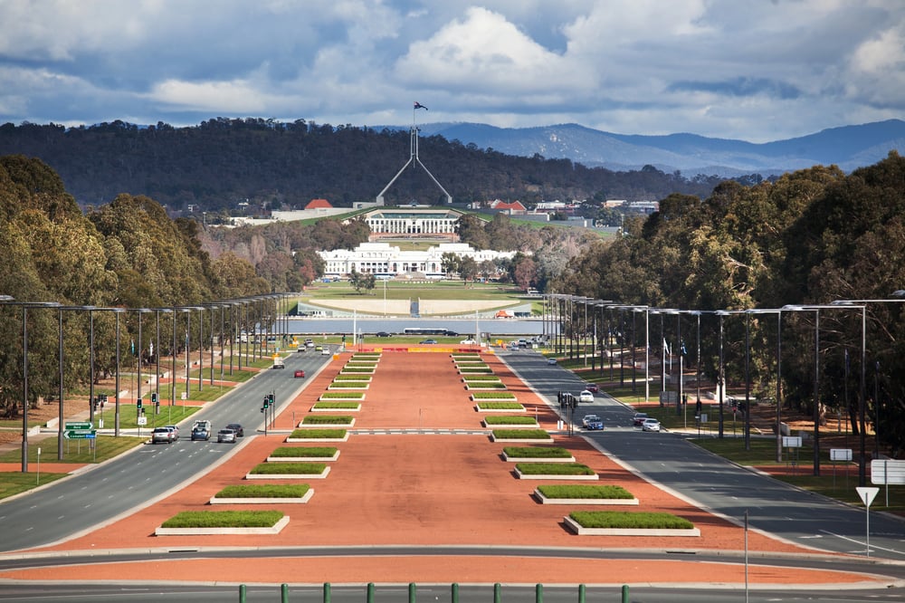
Sydney might be Australia’s most famous city, but Canberra has been the capital since 1927. This planned city was built specifically to serve as the capital, positioned between Sydney and Melbourne to settle their rivalry.
Many Americans automatically assume the biggest or most well-known city must be the capital, but that’s not always the case.
Like Go2Tutors’s content? Follow us on MSN.
Alaska and Hawaii on Maps

Most Americans have seen Alaska and Hawaii displayed in little boxes next to the continental United States on maps. This creates the illusion that these states are much closer to the mainland than they actually are.
Alaska is separated from the lower 48 states by Canada, while Hawaii sits about 2,400 miles southwest of California in the Pacific Ocean.
Mount Everest’s Location

While everyone knows Mount Everest is the world’s tallest mountain, many Americans place it entirely in Nepal. The peak actually sits right on the border between Nepal and Tibet (part of China).
Climbers can approach from either side, though the Nepal route tends to be more popular with Western mountaineers.
The Middle East and Africa Connection

Egypt often gets mentally separated from Africa in people’s minds because it’s frequently grouped with Middle Eastern countries. Egypt is definitely part of Africa, sitting in the continent’s northeast corner.
The confusion comes from Egypt’s cultural and political ties to the Middle East, but geography doesn’t lie – it’s an African nation.
Like Go2Tutors’s content? Follow us on MSN.
Greenland’s Size Illusion

Standard world maps make Greenland look absolutely massive, sometimes appearing larger than South America. In reality, Greenland is about one-eighth the size of South America.
This distortion happens because most maps use the Mercator projection, which stretches areas near the poles to fit them onto a flat surface.
Russia’s Continental Confusion

Russia is so enormous that it spans two continents, but many Americans think of it as purely European. About 75% of Russia’s land mass actually sits in Asia, though most of its population lives in the European portion.
This transcontinental country stretches from the Baltic Sea to the Pacific Ocean.
New Mexico’s Statehood Status

New Mexico has been a U.S. state since 1912, but some Americans still think it’s part of Mexico. This confusion has led to real-world problems, including delivery companies refusing to ship there and people needing passports to visit.
The state even had to add ‘USA’ to its license plates to clear up the confusion.
Like Go2Tutors’s content? Follow us on MSN.
Turkey’s Continental Position

Turkey creates geographic confusion because it sits in both Europe and Asia. The small European portion (about 3% of the country) is separated from the larger Asian portion by the Bosphorus strait.
Istanbul, the country’s largest city, actually straddles both continents, making it one of the world’s most geographically unique major cities.
The Great Lakes’ Borders

The Great Lakes don’t all belong entirely to the United States. Lake Superior, Lake Huron, Lake Erie, and Lake Ontario are all shared with Canada, while only Lake Michigan sits entirely within U.S. borders.
This misconception probably comes from the lakes being so prominent in American geography lessons.
South America’s Easternmost Point

Many Americans assume that South America’s easternmost point must be somewhere along Brazil’s coast. Actually, it’s in Brazil, but not where you’d expect – the easternmost point is near the city of Recife, which is just further east than the rest of the continent.
This bulge makes Brazil closer to Africa than many people realize.
Like Go2Tutors’s content? Follow us on MSN.
The Panama Canal’s Direction

The Panama Canal doesn’t run east-west as many Americans assume. Due to the way the isthmus curves, ships actually travel northwest from the Pacific to the Atlantic, or southeast going the other way.
This geographic quirk means the Pacific entrance is actually east of the Atlantic entrance.
Madagascar’s Continental Confusion

Madagascar often gets lumped in with generic ‘tropical islands’ in people’s minds, but it’s actually the world’s fourth-largest island and sits off the coast of Africa. The island separated from Africa about 160 million years ago, giving it unique plants and animals found nowhere else on Earth.
It’s definitely part of Africa, despite being surrounded by water.
Iran and Iraq’s Geographic Relationship

These two countries share a border, but many Americans picture them as being much farther apart. Iran sits to the east of Iraq, and they share about 900 miles of border.
The confusion might come from their different roles in recent conflicts, but geographically, they’re next-door neighbors in the Middle East.
Like Go2Tutors’s content? Follow us on MSN.
The Arctic Ocean’s Ice Status

Many Americans think the Arctic Ocean is just a frozen wasteland, but it’s actually a genuine ocean covered by sea ice. Unlike Antarctica, which is a continent covered by land ice, the Arctic is an ocean surrounded by land.
The ice floats on water, and climate change is dramatically reducing its coverage each year.
Maps That Shape Minds

These geographic misconceptions show how our mental maps of the world get shaped by the media we consume, the maps we see, and the stories we hear. In our interconnected world, understanding basic geography helps us make sense of international news, cultural differences, and global challenges.
The next time you hear someone make one of these common mistakes, you’ll know exactly how to set the record straight – and maybe learn something new about our fascinating planet in the process.
More from Go2Tutors!

- 16 Historical Figures Who Were Nothing Like You Think
- 12 Things Sold in the 80s That Are Now Illegal
- 15 VHS Tapes That Could Be Worth Thousands
- 17 Historical “What Ifs” That Would Have Changed Everything
- 18 TV Shows That Vanished Without a Finale
Like Go2Tutors’s content? Follow us on MSN.