15 Images Of Deadliest Earthquake Aftermaths in Recorded History
Without warning, the ground begins to shake. Moments later, pavement cracks open while structures give way beneath their own weight.
What remains sinks into heaps of debris almost instantly. Only when it ends do images show what’s left behind – hazy horizons thick with ash, highways split like broken spines, people motionless amid fragments of walls and roofs.
A deep dive into fifteen of the most lethal quakes ever documented – each one peeling back layers on how people break, adapt, survive. What came after showed cracks in systems, strength in communities, shifts that lingered long past the shaking stopped.
1556 Shaanxi Earthquake
The Shaanxi earthquake in China remains the worst to date, resulting in an estimated 830,000 fatalities. Some of the victims resided within yaodong cave systems that were carved out of the loess cliffs.
The quake resulted in instant collapses. The aftermath of the earthquake saw villages completely destroyed from the face of the earth.
Even centuries later, this event remains a poignant example of the interrelation between geology and architecture.
1976 Tangshan Earthquake

When a magnitude 7.5 earthquake struck Tangshan, China, in 1976, it flattened much of the industrial city. Official figures report approximately 240,000 deaths, though some estimates run higher.
Photographs from the aftermath show blocks of collapsed concrete and twisted steel. Entire neighborhoods appeared leveled.
In response, China overhauled building codes and invested heavily in seismic research, transforming tragedy into long-term reform.
2010 Haiti Earthquake

The 2010 earthquake near Port-au-Prince measured magnitude 7.0 but caused catastrophic destruction due to dense population and weak construction standards. Estimates place the death toll between 160,000 and 220,000.
Aftermath images show pancaked buildings and makeshift shelters stretching across open fields. Recovery proved complex and prolonged.
The disaster highlighted the devastating impact of inadequate infrastructure in seismic zones.
2004 Indian Ocean Earthquake And Tsunami

Although best known for the tsunami it triggered, the magnitude 9.1 earthquake off Sumatra was itself one of the most powerful ever recorded. The combined disaster killed over 230,000 people across fourteen countries.
Coastal towns were left unrecognizable. In some regions, shorelines shifted permanently.
The aftermath led to the development of expanded tsunami warning systems throughout the Indian Ocean basin.
1908 Messina Earthquake

The Messina earthquake struck southern Italy and Sicily in 1908, followed by a tsunami that compounded the destruction. Approximately 75,000 to 100,000 people lost their lives.
Photographs from the period show entire city blocks reduced to debris. Messina’s historic architecture was largely destroyed.
Reconstruction efforts reshaped the city’s layout and architectural standards.
1923 Great Kantō Earthquake

The Great Kantō earthquake devastated Tokyo and Yokohama in 1923, killing more than 100,000 people. Fires broke out across the cities, spreading rapidly through wooden structures.
Aftermath images reveal burned-out districts stretching for miles. The disaster prompted significant urban planning reforms in Japan, influencing building standards that would later prove critical in future earthquakes.
1960 Valdivia Earthquake

The Valdivia earthquake in Chile remains the most powerful ever recorded at magnitude 9.5. It triggered tsunamis that traveled across the Pacific Ocean.
Images from southern Chile show flooded towns and cracked earth. Entire coastal areas were reshaped.
The event reinforced Chile’s commitment to strict seismic construction standards, which have since mitigated damage in later quakes.
2011 Tōhoku Earthquake
Japan’s 2011 magnitude 9.0 earthquake triggered a massive tsunami that swept away entire coastal communities. Nearly 20,000 people died, and the disaster led to the Fukushima nuclear crisis.
Aftermath photographs show neighborhoods reduced to foundations and debris fields stretching toward the sea. Japan’s robust building codes limited structural collapse from the quake itself, underscoring the importance of preparedness.
1931 Hawke’s Bay Earthquake

New Zealand’s Hawke’s Bay earthquake in 1931 destroyed much of the city of Napier. Around 256 people died, a significant toll for the country at the time.
Images from the aftermath show collapsed masonry buildings lining once-busy streets. Napier was rebuilt in Art Deco style, giving the city a distinctive architectural identity that remains today.
1985 Mexico City Earthquake

A magnitude 8.0 earthquake struck Mexico City in 1985, causing widespread building collapses. Official estimates place the death toll in the thousands.
Photographs captured volunteers digging through debris by hand. The disaster exposed weaknesses in construction practices and led to stronger seismic regulations in Mexico.
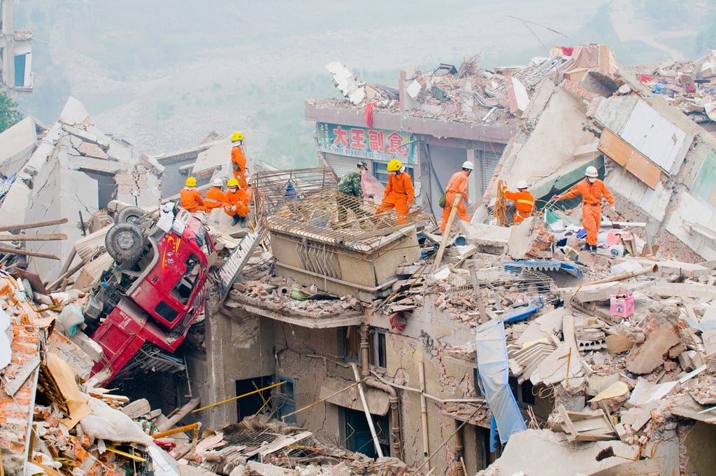
2008 Sichuan Earthquake

The 2008 Sichuan earthquake in China killed nearly 70,000 people and left millions homeless. Entire towns near the epicenter were devastated.
Aftermath images show collapsed schools and apartment blocks. Public scrutiny over building standards intensified, leading to renewed focus on construction safety in seismic regions.
1755 Lisbon Earthquake
The Lisbon earthquake of 1755 struck on a religious holiday, followed by a tsunami and fires. Tens of thousands died, and much of the Portuguese capital was destroyed.
Engravings from the era depict buildings reduced to rubble and citizens fleeing toward open ground. The disaster influenced Enlightenment-era discussions about science, faith, and natural disaster response.
1999 İzmit Earthquake

Turkey’s İzmit earthquake killed more than 17,000 people. Industrial facilities and residential buildings collapsed across the region.
Aftermath scenes showed highways fractured and apartment blocks flattened. The event prompted renewed debate in Turkey about seismic building standards and urban planning.
1948 Ashgabat Earthquake
The 1948 earthquake in Ashgabat, then part of the Soviet Union, destroyed much of the city. Official figures long remained unclear, but estimates suggest tens of thousands died.
Photographs reveal near-total devastation. The disaster remained underreported for years, illustrating how political context can shape public awareness of catastrophe.
2015 Nepal Earthquake

The Nepal earthquake of 2015 resulted in the loss of nearly 9,000 lives. The earthquake caused widespread destruction in the Kathmandu valley and the surrounding mountain villages.
The ancient structures and cultural sites suffered damage. The photographs of the aftermath show the destroyed brick structures and the camps.
After The Ground Stops Shaking

Shaking ground holds wild power in just seconds, yet what follows drags on through seasons. What remains in photos isn’t only broken walls.
Hidden in those frames are clues – how buildings were made, where people lived, whether warnings came early. Even though better designs and alerts save lives today, quakes still pose steady threats.
How we respond grows from past shocks, updating how structures are made, cities laid out, emergency plans drawn. After shaking stops, wreckage stays – yet so does a chance to rise tougher.
More from Go2Tutors!

- The Romanov Crown Jewels and Their Tragic Fate
- 13 Historical Mysteries That Science Still Can’t Solve
- Famous Hoaxes That Fooled the World for Years
- 15 Child Stars with Tragic Adult Lives
- 16 Famous Jewelry Pieces in History
Like Go2Tutors’s content? Follow us on MSN.