15 Most Surreal Natural Phenomena and the Science Behind Them
Nature has a way of making reality feel like fiction. Somewhere on Earth right now, stones are sliding across desert floors by themselves, leaving perfect trails behind them.
Fish are falling from cloudless skies onto startled pedestrians. Lakes are turning blood red overnight, and entire forests are humming with a sound no one can quite place.
These phenomena exist in the uncomfortable space between what seems possible and what actually happens. They’re documented, photographed, and studied — yet they still feel like elaborate tricks.
The science behind them is often straightforward once explained, but witnessing them firsthand tends to scramble people’s understanding of how the world works.
Sailing Stones
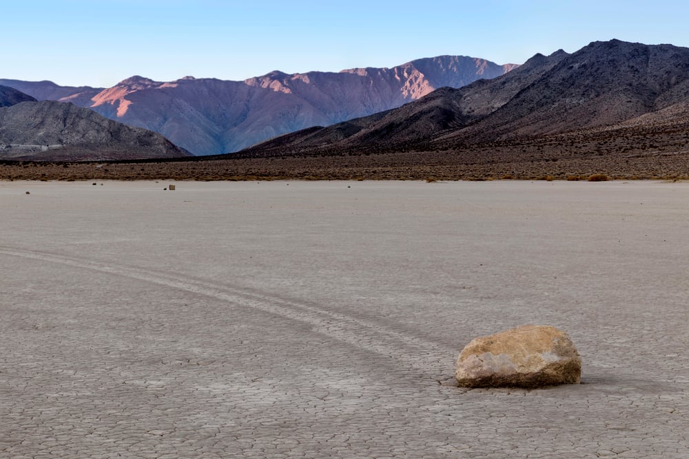
Death Valley’s Racetrack Playa hosts one of geology’s most stubborn mysteries — until recently. Massive boulders, some weighing hundreds of pounds, slide across the flat desert floor and leave perfectly straight trails behind them.
The stones move at night when no one’s watching. Scientists finally cracked this one in 2014. It requires a precise sequence: rare winter rains flood the playa, creating a shallow lake.
On cold nights, thin ice sheets form. When morning sun breaks the ice into large floating panels, even light winds can push these ice rafts around, and they shove the rocks along the muddy bottom like bulldozers.
The trails remain long after the water evaporates. What looked supernatural was just ice doing heavy lifting.
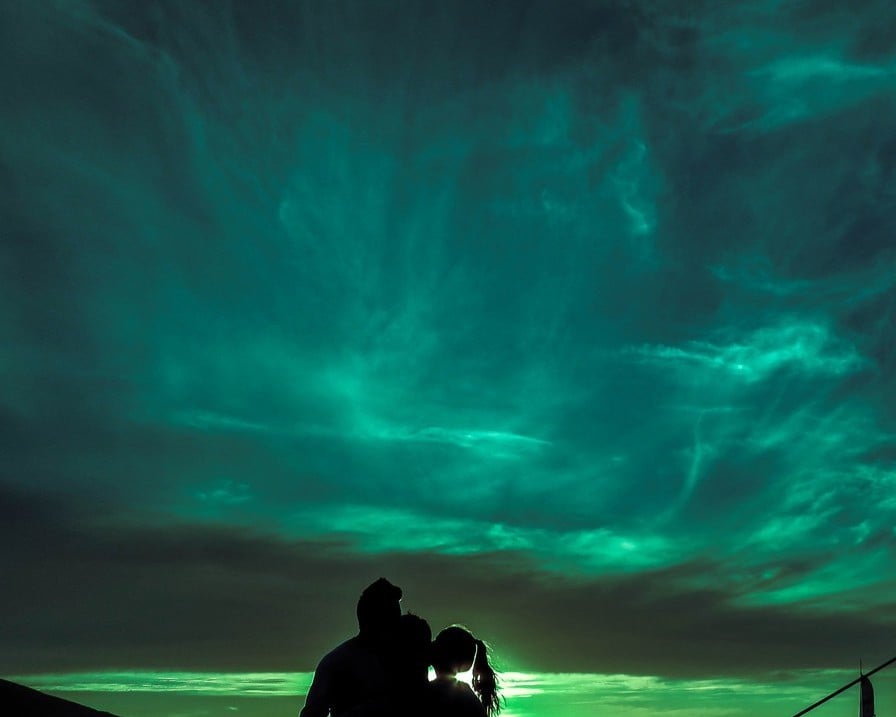
Aurora Borealis
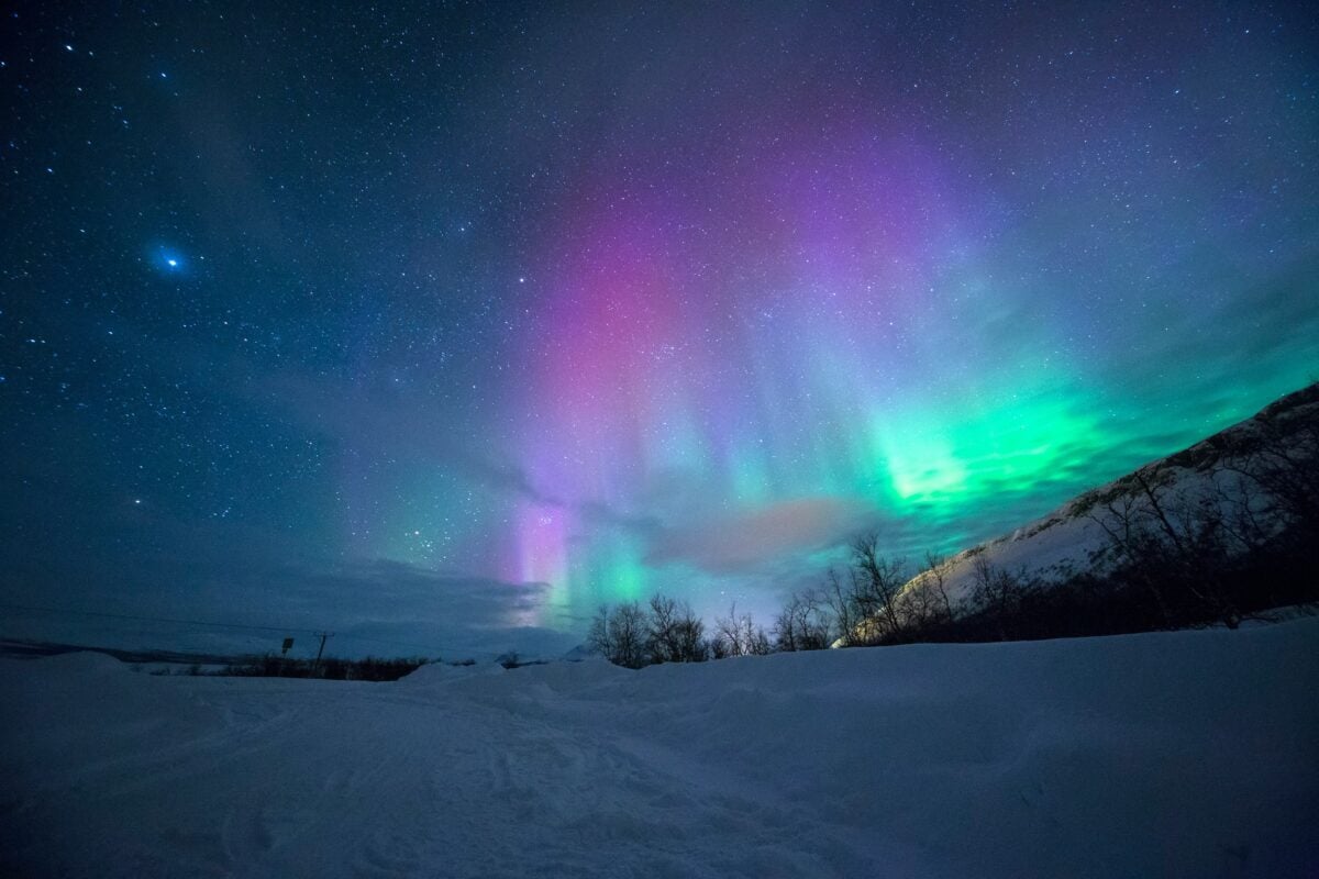
The northern lights happen because Earth lives inside the sun’s breath, and sometimes that breath gets violent (which sounds more poetic than it has any right to, but that’s essentially what’s happening when you strip away the technical language). Solar wind — a stream of charged particles constantly flowing from the sun — usually gets deflected by Earth’s magnetic field, but during solar storms, some particles slip through and dive toward the magnetic poles.
They collide with oxygen and nitrogen atoms in the upper atmosphere, and those collisions release energy as light. Green comes from oxygen at lower altitudes, red from oxygen higher up, and blue-purple from nitrogen — though the colors blend and dance because the atmosphere doesn’t organize itself into neat layers, and the particles don’t arrive in orderly fashion.
The lights appear to move and pulse because the solar wind isn’t steady; it surges and retreats, and Earth’s magnetic field flexes in response. So you get this shifting curtain of light that looks almost alive, almost conscious, when really it’s just physics playing with chemistry about 60 miles above your head.
But knowing the mechanism doesn’t make it less beautiful — if anything, it makes it more remarkable that something so ethereal emerges from something so mechanical.
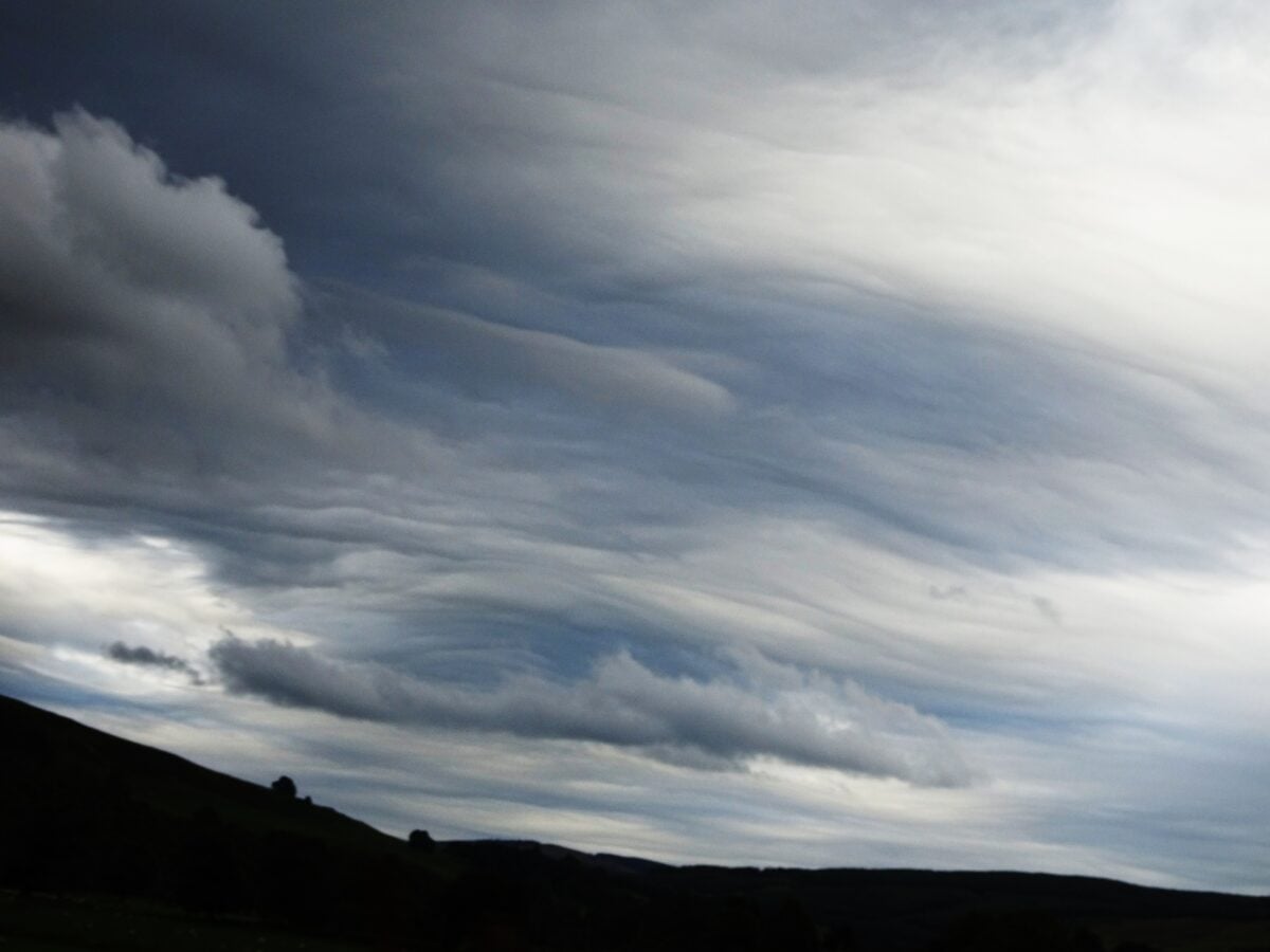
Morning Glory Clouds

Northern Australia produces the world’s most reliable atmospheric roll clouds. Morning Glory clouds stretch up to 600 miles long, roll forward like horizontal tornadoes, and arrive so predictably that glider pilots plan vacations around them.
They form when sea breezes from opposite coasts of the Cape York Peninsula collide inland. The collision creates a pressure wave that travels back toward the Gulf of Carpentaria. As this wave moves, it forces moist air upward, where it cools and condenses into a rotating cylinder of cloud.
The cloud appears to roll because the air inside it actually is rolling — rising at the front, flowing back along the top, descending at the rear, and rushing forward along the bottom. What makes Morning Glory clouds particularly strange is their consistency.
Most atmospheric phenomena are chaotic and unpredictable. These clouds show up like scheduled trains, following the same path at roughly the same time each morning during the right season.
The atmosphere, it turns out, can be surprisingly organized when the conditions align properly.
Bioluminescent Waves
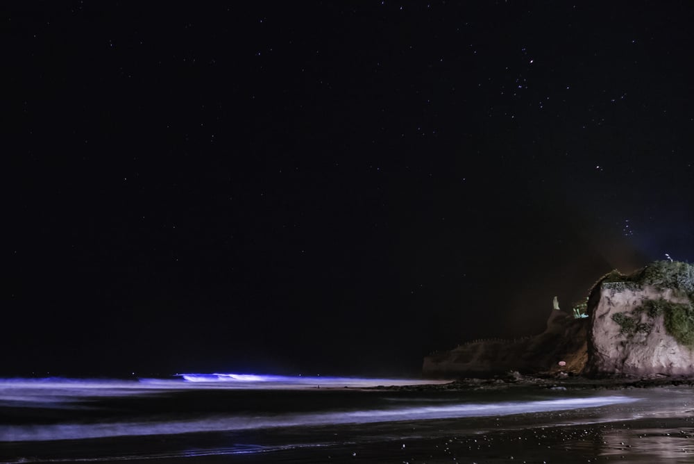
The ocean sometimes glows blue when disturbed, and it’s because of tiny organisms having what amounts to a panic attack (though calling it that makes it sound more dramatic than it needs to be, but the comparison isn’t entirely wrong since the light is essentially a stress response). Dinoflagellates — single-celled marine plankton — produce light when agitated, probably as a defense mechanism to startle predators or attract larger predators to eat whatever’s threatening them.
The light comes from a chemical reaction between luciferin and luciferase, the same compounds that make fireflies glow. When conditions are right — warm water, plenty of nutrients, and massive dinoflagellate populations — every wave and splash triggers millions of these microscopic light shows simultaneously.
Surfers leave glowing trails behind their boards. Swimmers emerge from the water outlined in blue fire.
Even footsteps on wet sand can trigger the effect if enough of the organisms have washed ashore. The phenomenon is beautiful but often indicates an algae bloom, which can be toxic to marine life and humans, so the glow comes with an environmental cost that makes it less romantic than it appears.
Blood Rain
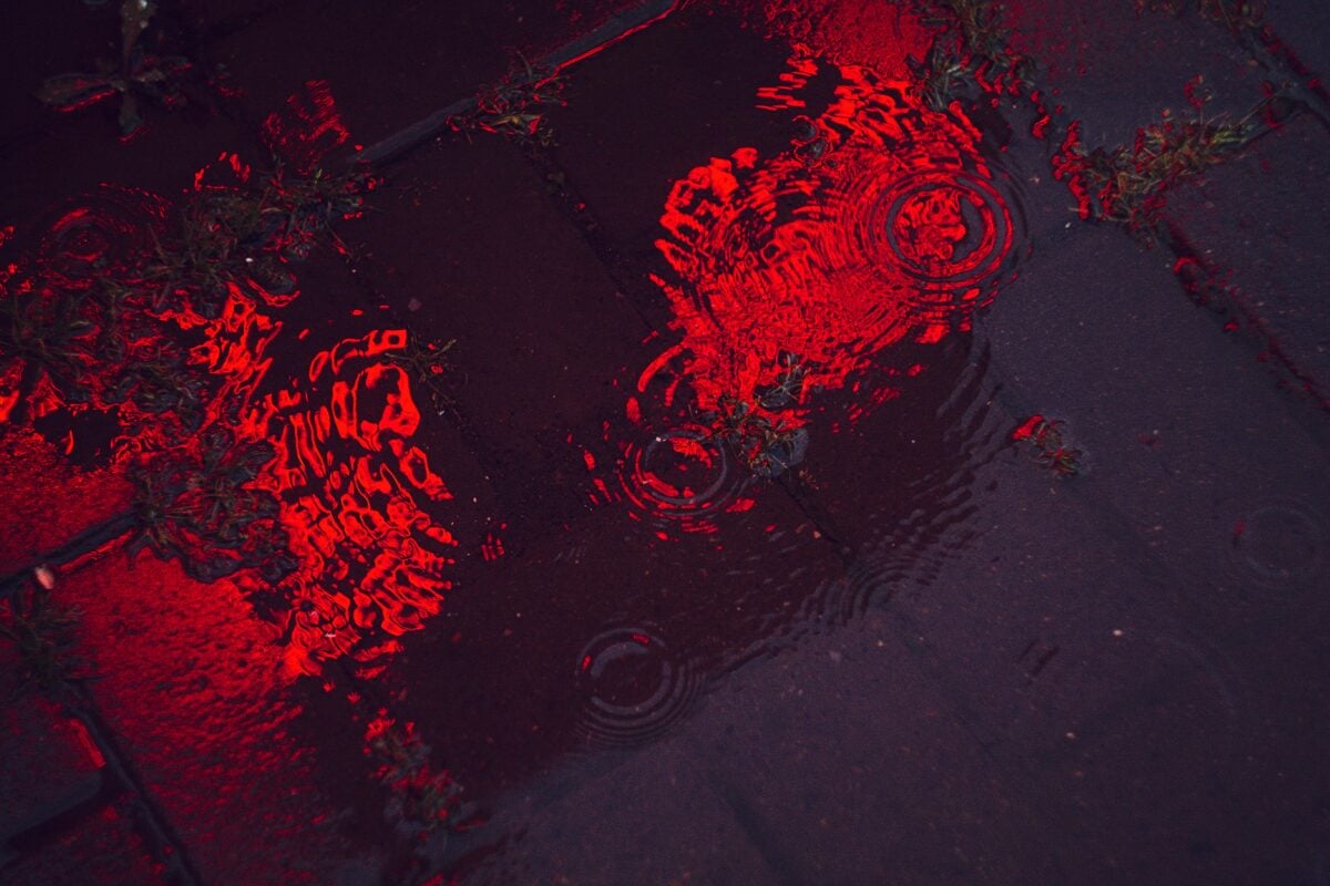
Red rain falls occasionally, and people used to think it meant the apocalypse was starting. The explanation is more mundane but arguably more interesting: dust from the Sahara Desert gets caught in weather systems and travels thousands of miles before falling with precipitation.
When it rains in parts of Europe, the water comes down tinted red or orange from African sand. The journey these particles take is remarkable.
Dust storms in the Sahara can lift millions of tons of sediment into the atmosphere. Trade winds carry this dust across the Atlantic, where it fertilizes Amazon rainforests and Caribbean beaches.
Some of it gets caught in European weather patterns and comes down with the next storm. Kerala, India, experienced particularly dramatic blood rain in 2001. Some researchers proposed it contained extraterrestrial cells, but later analysis confirmed it was just dust — likely from local sand or possibly spores from local algae.
The red color made it seem supernatural, but it was just geology taking a scenic route through the sky.
Asperitas Clouds
The newest cloud type was officially recognized in 2017, though people had been photographing these dramatic formations for years without knowing what to call them. Asperitas clouds look like ocean waves viewed from underwater — dark, rolling formations that appear to be on the verge of crashing down from the sky.
They form when different air masses with varying temperatures and humidity levels create turbulence at their boundary. The result is a cloud base that appears to flow and churn, creating patterns that look more liquid than atmospheric.
The name comes from the Latin word for roughness, which fits their choppy, turbulent appearance. What makes asperitas clouds particularly striking is how they seem to violate expectations about how clouds should behave.
Most clouds form relatively smooth, predictable shapes. These look chaotic and threatening, as if the sky is experiencing some kind of distress.
They’re actually harmless — more of an atmospheric art display than a weather threat.
Mammatus Clouds
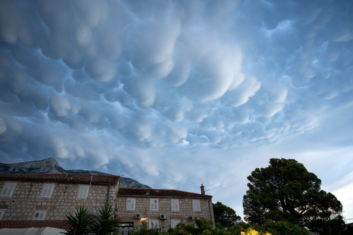
Nature builds clouds upside down sometimes. Most clouds grow upward as warm air rises and cools, but mammatus clouds form when dense, cold air sinks through the cloud base, creating pouches that hang down like udders.
The name comes from the Latin word for breast or udder, which is anatomically accurate if not particularly poetic. These formations appear most commonly after severe thunderstorms.
The storm cloud’s downdraft contains air that’s denser than the surrounding atmosphere, so it keeps sinking even after reaching the cloud’s normal base altitude. This creates the distinctive bulging formations that seem to droop from the sky.
Mammatus clouds signal that the atmosphere is particularly unstable. They don’t cause severe weather themselves, but they often accompany it.
Seeing them usually means interesting weather is either happening or about to happen. They’re essentially a sign that the sky doesn’t know which way is up at the moment.
Catatumbo Lightning
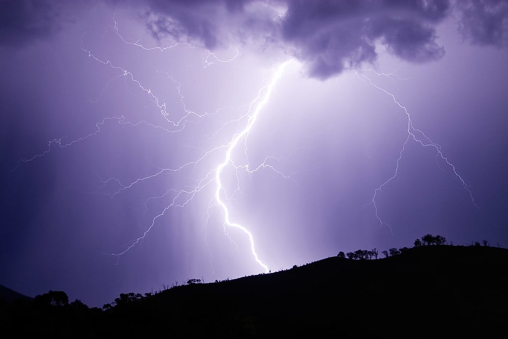
Venezuela’s Catatumbo River produces lightning shows that run for hours with no thunder and barely any rain (and when you consider that lightning without thunder seems to violate basic physics, though it doesn’t really — the thunder is just too far away to hear, but that’s not immediately obvious when you’re watching silent electrical storms paint the sky for 300 nights a year). The phenomenon occurs where the river meets Lake Maracaibo, creating a perfect storm factory that generates up to 250 lightning strikes per minute during peak activity.
The mechanics involve geography and meteorology working together in an almost engineered way: trade winds carrying moisture from the Caribbean collide with cold air flowing down from the Andes Mountains, creating powerful updrafts over the lake. The surrounding mountains trap this rising air, forcing it higher into the atmosphere where it forms massive cumulonimbus clouds.
These clouds generate electrical activity for hours at a time, sometimes lasting 10 hours per night during the rainy season. Local people call it the “eternal storm,” and it’s been documented since the 1500s, making it one of the most reliable natural light shows on Earth.
But the consistency is almost unsettling — nature isn’t supposed to be this predictable, yet here it is, throwing lightning parties on schedule.
Frost Flowers

Arctic seas grow delicate ice sculptures that look like someone scattered crystal flowers across the frozen surface. Frost flowers form when air temperatures drop significantly below the freezing point of seawater, creating a temperature differential that pulls moisture from the relatively warm ocean through tiny cracks in new sea ice.
This moisture instantly freezes upon contact with the frigid air, building up in thin, curved layers that resemble petals. The “flowers” can grow several inches tall and are so delicate that a gentle breeze can destroy them.
They typically form on young sea ice that’s only a few days old, when the ice is still thin enough to allow heat and moisture transfer from the ocean below. Frost flowers concentrate salt and other chemicals from seawater as they form, creating formations that can be several times saltier than the ocean itself.
They also trap bacteria and other microorganisms, making them small but complex ecosystems. These fragile structures exist in one of Earth’s harshest environments, yet they’re too delicate to survive human touch.
Green Flash
The sun turns green for exactly one second at sunset under perfect conditions. This happens because Earth’s atmosphere acts like a giant prism, bending different colors of sunlight by slightly different amounts.
Green light bends more than red light but less than blue light. During sunset, the sun’s light passes through increasingly thick layers of atmosphere.
Red light, which bends the least, disappears first from the observer’s perspective. Blue and violet light scatter away completely.
Green light, being in the middle of the spectrum, persists just long enough to be the last color visible as the sun’s disk vanishes below the horizon. The effect requires an extremely clear atmosphere and an unobstructed horizon — usually over ocean or flat desert.
Any haze, clouds, or atmospheric disturbance will prevent it. Even under ideal conditions, the green flash lasts only a moment, which explains why many people dismiss reports of it as optical illusions or wishful thinking.
Fire Whirls
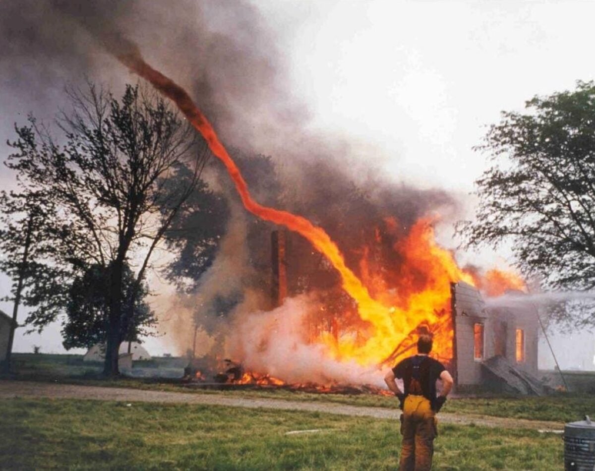
Wildfires sometimes spawn tornadoes made of flame. Fire whirls form when intense heat from a large fire creates powerful updrafts that begin to rotate, pulling flames and burning debris up into a spinning column that can reach hundreds of feet high.
The rotation intensifies through the same mechanism that makes figure skaters spin faster when they pull their arms in — as the column of rising air tightens, it spins more rapidly. These flame tornadoes can generate winds exceeding 100 mph and temperatures over 2,000 degrees Fahrenheit.
They move independently of the main fire, making them particularly dangerous and unpredictable. Unlike regular tornadoes, which form from storm clouds, fire whirls create their own weather system through the sheer intensity of the heat they generate.
The 1923 Great Kanto earthquake in Japan produced a fire whirl that killed 38,000 people in just 15 minutes. More recently, the 2018 Carr Fire in California generated a fire tornado with winds reaching 143 mph — strong enough to be classified as an EF-3 tornado.
These events demonstrate that fire can become its own weather phenomenon under extreme conditions.
Penitentes
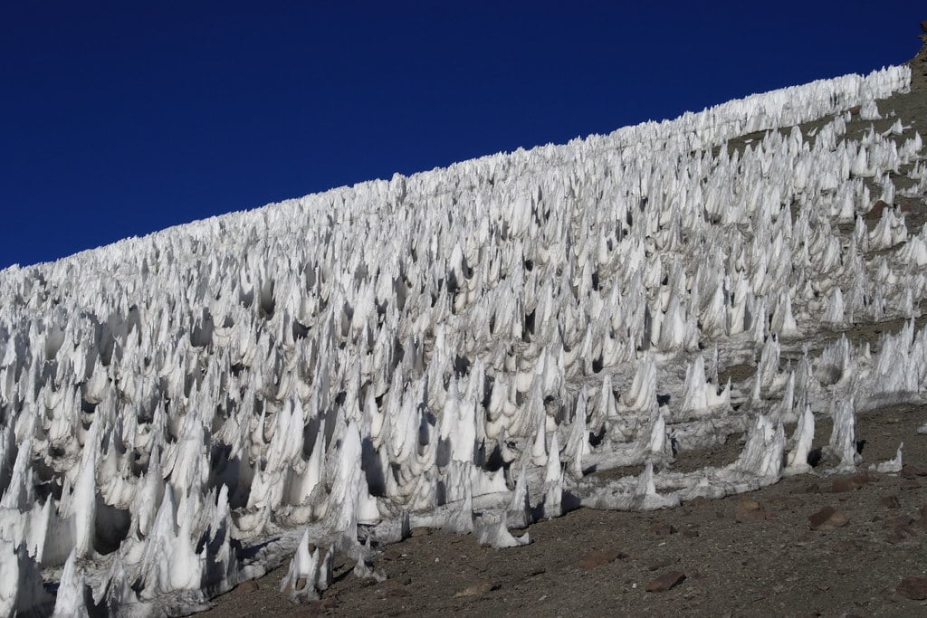
The Andes Mountains grow forests of snow and ice spires that point toward the sun like frozen prayer hands. Penitentes form through sublimation — the direct transition from solid ice to water vapor without melting.
At high altitudes where the air is thin and dry, ice sublimates faster in some areas than others, creating differential erosion that carves the snow into blade-like formations. The spires can grow up to 15 feet tall and form in remarkably regular patterns across entire mountainsides.
They align themselves perpendicular to the sun’s rays, which is why they appear to be reaching toward the sky. The name comes from the resemblance to hooded penitents in religious processions.
What makes penitentes particularly striking is their precision. They form in neat rows with consistent spacing and similar heights, as if someone organized them deliberately.
The effect is so regular that some early explorers suspected they were artificial structures. Instead, they’re the result of physics creating order from chaos through simple, repetitive processes repeated thousands of times.
St. Elmo’s Fire
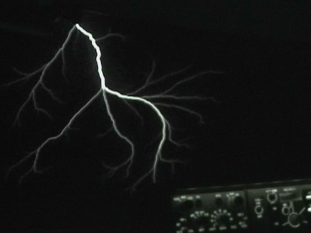
Ships’ masts glow with ghostly flames during thunderstorms, and sailors used to think it meant they were blessed or cursed depending on the color. St. Elmo’s fire is actually a corona discharge — the same electrical phenomenon that makes neon signs work, just occurring naturally during storms when the electrical field in the atmosphere becomes strong enough to ionize air molecules around pointed objects.
The “fire” appears most commonly on ship masts, airplane wings, and church spires during thunderstorms. It’s not actually fire at all, just glowing plasma created when electricity jumps between the charged atmosphere and a conductor.
The light is usually blue or violet, though it can appear white or green depending on the gases involved in the ionization. Despite its ethereal appearance, St. Elmo’s fire indicates extremely dangerous conditions — it means the electrical field is strong enough that lightning could strike at any moment.
Pilots who encounter it typically change course immediately. The phenomenon is beautiful but serves as nature’s way of announcing that the air is electrically loaded and potentially lethal.
Supercells
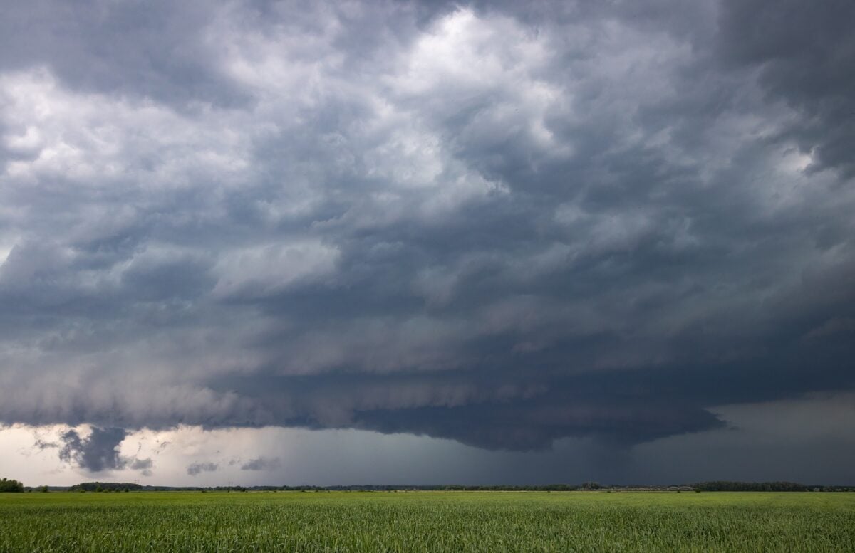
Some thunderstorms develop personalities and start acting like they’re trying to drill pits through the atmosphere (which isn’t far from what actually happens when you look at the vertical structure of these systems — they can punch through the troposphere into the stratosphere, reaching heights of 50,000 feet or more, creating their own weather patterns that can dominate hundreds of square miles for hours at a time). Supercells form when wind speed and direction change dramatically with altitude, creating wind shear that causes the entire storm system to rotate.
This rotation, called a mesocyclone, can persist for hours and gives the storm a distinctive structure that’s visible both on radar and from the ground. Unlike ordinary thunderstorms that build up and dissipate relatively quickly, supercells are self-sustaining systems that feed on their own energy.
The rotating updraft separates the inflow from the outflow, preventing the storm from choking on its own downdraft — which is what kills most thunderstorms within an hour or two. Supercells can last all day, traveling hundreds of miles while maintaining their structure and intensity.
They produce the strongest tornadoes, the largest hail, and some of the most destructive winds on Earth. And they’re beautiful in a terrifying way — these massive rotating towers of clouds that seem to operate by their own rules, independent of the surrounding weather patterns.
Brinicles
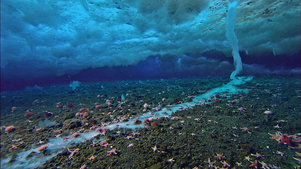
Antarctica’s seafloor experiences underwater blizzards of death. Brinicles form when extremely cold, dense brine sinks from sea ice above, creating a tube of rapidly freezing seawater that descends toward the ocean floor like an icy stalactite.
The brine is so cold and salt-concentrated that it freezes everything it touches, including fish and sea stars unlucky enough to be in its path. The process begins when sea ice forms at the surface.
As seawater freezes, it expels salt, creating pockets of super-concentrated brine that’s both denser and colder than the surrounding water. This brine sinks through the water column, and its extreme cold causes the less-salty seawater around it to freeze on contact, building a growing tube of ice that can extend all the way to the seafloor.
When a brinicle reaches the bottom, it spreads out like a pool of freezing death, instantly killing slow-moving sea life. Time-lapse photography reveals the process happening with surprising speed — what looks like it should take hours actually occurs in minutes.
It’s one of the few natural phenomena that resembles something from science fiction more than anything typically associated with Earth’s oceans.
Monarch Butterfly Migration

Millions of butterflies navigate 3,000 miles using a compass no one fully understands. Monarch butterflies travel from Canada to central Mexico every fall, following routes they’ve never flown before to reach forests they’ve never seen.
The journey takes multiple generations — the butterflies that arrive in Mexico are the great-great-grandchildren of the ones that left the previous spring. The navigation mechanism combines several systems that shouldn’t work together as precisely as they do.
Monarchs use the sun’s position compensated for time of day, magnetic field detection, and possibly infrasound or other environmental cues. They can maintain heading accuracy within a few degrees across thousands of miles, which rivals the precision of human navigation systems.
What makes this particularly remarkable is that the butterflies completing the journey have never made it before. The final generation lives longer than the others — up to eight months instead of the usual six weeks — and possesses navigation information that’s somehow encoded in their genes.
They’re flying on inherited memory
More from Go2Tutors!

- The Romanov Crown Jewels and Their Tragic Fate
- 13 Historical Mysteries That Science Still Can’t Solve
- Famous Hoaxes That Fooled the World for Years
- 15 Child Stars with Tragic Adult Lives
- 16 Famous Jewelry Pieces in History
Like Go2Tutors’s content? Follow us on MSN.