Facts About the Grand Canyon Viewpoints
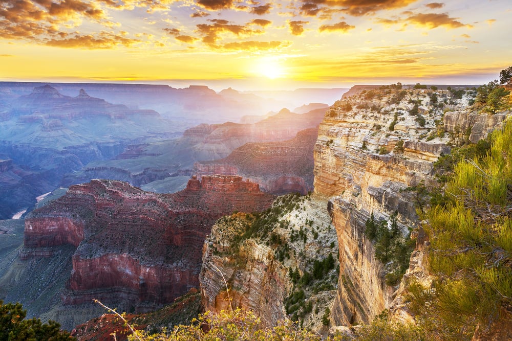
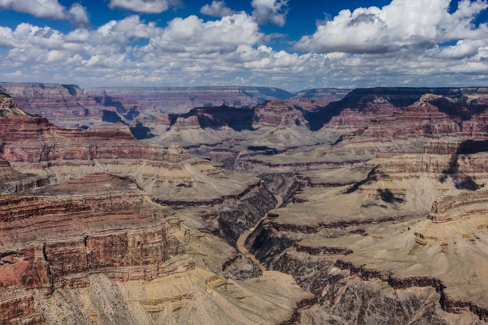
The Grand Canyon stretches 277 miles across northern Arizona, and standing at the edge feels like looking at another planet. Nearly five million people visit each year, but most only see a handful of the same crowded spots.
The canyon has dozens of viewpoints scattered along both rims, and each one offers something completely different. Some require hiking, others sit right next to parking lots, and a few remain so remote that hardly anyone bothers making the trip.
Knowing which viewpoints to visit can turn a good trip into an unforgettable one. The differences between locations matter more than most people realize.
Mather Point sees more visitors than any other spot

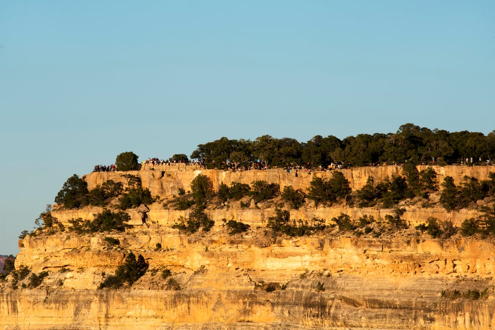
Mather Point sits right near the main visitor center on the South Rim, which explains why roughly 30% of all Grand Canyon visitors end up here first. The parking lot dumps people out just a short walk from the rim, making it the default choice for anyone entering through the south entrance.
Tour buses line up here constantly during peak season, and finding space at the railings during midday in summer becomes a contact sport. The view itself spans wide and shows multiple layers of the canyon, including a clear look at the Colorado River below.
Despite the crowds, sunrise at Mather Point actually works well because the eastern exposure lights up the canyon walls in shades of orange and red that photographs never quite capture correctly.
Desert View offers the tallest structure on the South Rim

The Desert View Watchtower rises 70 feet above the rim and was designed by Mary Colter in 1932 to look like ancient Puebloan towers. Climbing the interior stairs leads to windows at different levels, each framing distinct sections of the canyon.
This viewpoint sits at the far eastern end of the South Rim, about 25 miles from Grand Canyon Village, which means far fewer people make the drive out here. The location provides views of the Painted Desert stretching toward the horizon and shows where the Little Colorado River merges with the main Colorado River.
The watchtower itself contains murals by Hopi artist Fred Kabotie, and the gift shop sells Native American crafts that actually come from local artisans rather than generic tourist junk.
Yavapai Point has the best geology exhibit

The Yavapai Geology Museum sits right at this viewpoint and uses floor-to-ceiling windows that turn the canyon itself into a giant teaching display. Rangers placed labels on the windows that identify specific rock layers, peaks, and formations visible across the canyon, making it perfect for anyone wanting to understand what they’re actually looking at.
The museum explains how the canyon formed over millions of years using simple displays that kids can follow without getting bored. This viewpoint sits close to Mather Point but attracts fewer crowds because it requires a slightly longer walk from the main village area.
The rim here juts out enough to provide views both east and west along the canyon, and the sunrise views rival anything on the South Rim.
Bright Angel Point provides the easiest North Rim access

The North Rim sits 1,000 feet higher than the South Rim and receives only 10% of total park visitors, mostly because getting there requires a 220-mile drive around the canyon. Bright Angel Point extends out on a narrow peninsula with canyon views on three sides, and the paved trail from the parking lot covers just half a mile round trip.
The higher elevation means temperatures run about 10 degrees cooler than the South Rim, and the forest here consists of spruce and fir rather than pinyon and juniper. Standing at the point provides a direct view across to the South Rim developments, and on quiet mornings the silence feels almost unsettling compared to the constant chatter at southern viewpoints.
The North Rim only opens from mid-May through mid-October because winter snow makes the access road impassable.
Hopi Point ranks as the best sunset location
Photographers and sunset chasers pack this viewpoint every evening during summer, and park rangers sometimes have to manage the crowds to keep everyone safe. The point extends far out into the canyon, providing unobstructed western views that catch the sun as it drops toward the horizon.
The rock formations here create natural frames for photographs, and the way the light changes color across the canyon walls during the last 30 minutes before sunset explains why people tolerate the crowds. Rangers recommend arriving at least 45 minutes early during peak season just to find parking and claim a spot at the rim.
The shuttle bus stops here, making it accessible without driving, though the return shuttles after sunset fill up fast and sometimes people wait through multiple buses before getting a spot.
Lipan Point shows the Colorado River clearly

Most South Rim viewpoints offer glimpses of the river, but Lipan Point provides one of the few spots where the Colorado appears clearly without needing binoculars. The point sits on the eastern section of the South Rim, and the canyon widens here enough that the river doesn’t hide in shadows for most of the day.
This location works particularly well for sunrise because the eastern exposure lights up first, and the river reflects the early morning colors. Fewer people make it out to Lipan Point compared to the main village viewpoints, though it sits right along the main road and requires no hiking.
The view extends far enough to see the Unkar Delta, where ancient Puebloan people farmed centuries ago, and on clear days the Painted Desert becomes visible in the distance.
Toroweap Overlook requires serious commitment

Getting to Toroweap demands driving 60 miles on unpaved roads that turn impassable when wet, and the journey from the nearest paved highway takes about three hours. The payoff comes from standing at a viewpoint where the canyon walls drop 3,000 feet straight down to the Colorado River with no guardrails or barriers.
Only about 3,000 people visit Toroweap each year compared to millions at the main rim areas, and the primitive campground nearby contains just 10 sites. High-clearance vehicles handle the road better, though regular cars can make it during dry conditions if drivers take it slow.
The isolation and raw exposure at this viewpoint create an entirely different experience from the developed rim areas, and standing at the edge here brings out primal feelings that railings and crowds tend to diminish.
Hermit’s Rest combines views with historic architecture
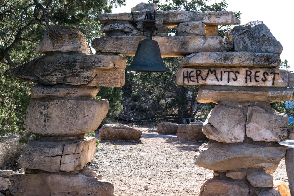
Mary Colter designed this building in 1914 to look like a prospector’s shelter, complete with a stone fireplace and rough-hewn beams that make it feel centuries old. The structure sits at the western end of Hermit Road, which closes to private vehicles from March through November, making the shuttle bus the only option for most of the year.
The viewpoint itself provides excellent western views and works well for sunset, though the crowds rarely reach the intensity found at Hopi Point. Inside, the fireplace actually works, and during colder months visitors gather around it between venturing out to the rim.
The building also contains a snack bar and gift shop, making it a practical stop for anyone hiking the Hermit Trail, which begins just below the rim here.
Mohave Point offers the best view of rapids

Three sets of rapids appear clearly from this viewpoint, including Hermit Rapids, which kayakers and rafters run about 1,400 feet below. The sound of rushing water sometimes carries up to the rim on quiet days, though it takes concentration to pick it out from wind noise.
This point sits along Hermit Road between Hopi Point and Hermit’s Rest, and the shuttle bus stops here throughout the day. The view extends both up and down canyon, showing how the Colorado River carved its path through the rock layers.
Photographers favor this spot for capturing the river’s movement, and the angle of the cliffs creates interesting shadow patterns during late afternoon. Mohave Point attracts fewer crowds than nearby Hopi Point despite offering comparable views, probably because sunset chasers focus on the more famous location.
Cape Royal provides the North Rim’s most expansive view
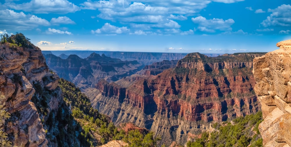
The paved road to Cape Royal extends 23 miles from the North Rim visitor center, and the viewpoint sits at the end of a peninsula that juts far into the canyon. The short paved trail from the parking area passes through natural arches and leads to a point where the canyon opens up on three sides.
This viewpoint shows more of the canyon in a single view than any other easily accessible location, and on clear days visibility extends over 100 miles. Angels Window, a natural arch just off the main point, frames a view of the Colorado River and makes for stunning photographs.
The North Rim’s limited season and lower visitor numbers mean Cape Royal rarely feels crowded even during peak summer months, and finding parking presents no challenge.
Grandview Point sits at the highest elevation on the South Rim

At 7,400 feet above sea level, Grandview Point towers about 400 feet higher than Grand Canyon Village, and the extra elevation provides a noticeably different perspective. The viewpoint got its name from miners who used this area as their main access point to copper deposits deep in the canyon during the 1890s.
The Grandview Trail, one of the steepest maintained trails in the park, begins here and drops 3,000 feet in just three miles. The viewpoint itself requires minimal walking from the parking area, and the location about 12 miles east of the village means it sees moderate rather than heavy traffic.
The higher elevation and exposure make Grandview Point windier and cooler than locations closer to the village, and winter snow often lingers here longer than other South Rim viewpoints.
Shoshone Point rewards hikers with solitude
This viewpoint sits just 1.2 miles down an unmarked dirt road that branches off the main rim road between Yaki and Grandview Points. Park regulations allow visitors to walk this route, but most people drive past without knowing it exists.
The point extends out on a narrow peninsula with expansive views both east and west, and finding another person here qualifies as unusual even during busy summer months. Rangers sometimes close the road for private events like weddings, but otherwise it remains open to anyone willing to make the walk.
The trail stays relatively flat and easy, making the solitude almost embarrassingly easy to achieve. Shoshone Point demonstrates how quickly the Grand Canyon experience changes once visitors step away from the most accessible spots.
Pima Point shows western canyon and historical mining
This viewpoint sits near the end of Hermit Road and provides unobstructed western views along with clear sightlines to Hermit Camp ruins far below. The camp, built in 1912 to house tourists, once offered overnight accommodations accessed via the Hermit Trail.
Pima Point works well for afternoon and sunset viewing because the western exposure keeps the main features lit longer than eastern viewpoints. The shuttle bus stops here, though fewer people get off compared to Hopi Point or Hermit’s Rest.
From this spot, the canyon extends toward the western regions that eventually lead to Lake Mead, and on exceptionally clear days the higher peaks near the North Rim become visible. The point also offers views of several rapid sections in the Colorado River, making binoculars worth bringing along.
Yaki Point’s only reachable by shuttle nearly every month

From March to November, you can’t drive to Yaki Point – so hopping on a shuttle or biking are your only ways in when it’s most crowded. That rule helps control foot traffic, so the place feels calmer compared to areas where cars show up any time.
Close by, the South Kaibab Trail kicks off, and plenty of hikers catch the bus early to start walking at daybreak. Since Yaki juts deep into the gorge, it gives sharp sunrise looks; also, facing southeast means sunlight slices across rock faces just right, lighting up rusty and golden bands.
The spot’s only a short drive east from Grand Canyon Village, yet it seems way farther due to limited entry. You’ll commonly see ravens or California condors gliding right by you here – seeing those huge birds catch warm air currents stays exciting every single time.
At 8,000 feet, Point Imperial tops all lookouts here

Standing tall at 8,803 feet, Point Imperial beats every other built-up overlook in Grand Canyon National Park. It’s tucked into the far northeast tip of the North Rim – roughly 11 miles from where most visitors hang out.
From this spot, your eyes land on the eastern stretch of the canyon plus Marble Canyon instead of the central gorge, giving a whole new look. Because it’s so high up, you’ll find thick stands of aspen and spruce; by late September, those aspens blaze bright gold.
Point Imperial sees less foot traffic compared to Bright Angel Point or Cape Royal – main reason being it’s tucked farther out from the lodge zone. Its parking fits about two dozen vehicles, so jam-packed scenes never really pop up around here.
Powell Point honors early canyon exploration
This spot marks the 1869 journey guided by John Wesley Powell – the first recorded passage down the river inside the Grand Canyon. Located on Hermit Road, between Maricopa and Hopi Points, it’s a stop for the shuttle bus.
Instead of just calling it brave, the plaque explains how uncertain things were – wooden boats, no maps, deep canyons. You get a decent look toward the western stretch of the gorge, but honestly, the scenery feels similar to what you’ve already seen nearby.
Some people overlook Powell Point when hurrying to well-known places, so you’ll usually find calm here if you just want to relax by the edge without crowds. History buffs might care more about the monument than others do; still, the signs break down the journey simply, making it easier to picture what happened.
The sight from the beginning spot

Back when railroads first reached the area, tourists started coming to see the Grand Canyon up close – early cabins went up nearby where South Rim town now stands. Folks back then caught sights pretty similar to what you’ll find today at Mather and Yavapai lookouts; only difference? They rolled in by train instead of driving, plus there weren’t hordes of strangers packed around them.
Even now, those scattered edge-side overlooks do exactly what they always did – help folks glimpse something way bigger than daily life usually offers. Sure, the canyon’s shape looks nearly identical after 100 years of visitor traffic.
But how we get here shifted hard – now it’s a few hours’ trip versus an entire journey lasting days. Busy areas might leave you feeling squeezed during peak times, yet plenty of viewing spots are out there; if you don’t mind hiking short stretches or veering off main roads, quiet corners aren’t tough to track down.
More from Go2Tutors!

- The Romanov Crown Jewels and Their Tragic Fate
- 13 Historical Mysteries That Science Still Can’t Solve
- Famous Hoaxes That Fooled the World for Years
- 15 Child Stars with Tragic Adult Lives
- 16 Famous Jewelry Pieces in History
Like Go2Tutors’s content? Follow us on MSN.