14 Maps That Predicted the Future with Eerie Accuracy
Throughout history, cartographers have done more than document the world as it existed – they’ve sometimes glimpsed what was yet to come. Behind certain maps lie remarkable stories of prediction, projection, and occasional prophecy.
These visual documents reveal how geographical imagination sometimes preceded reality with uncanny precision. Here is a list of 14 maps that predicted future developments with sometimes startling accuracy, showing how careful observation and analysis can occasionally pierce the veil of time.
The Waldseemüller Map
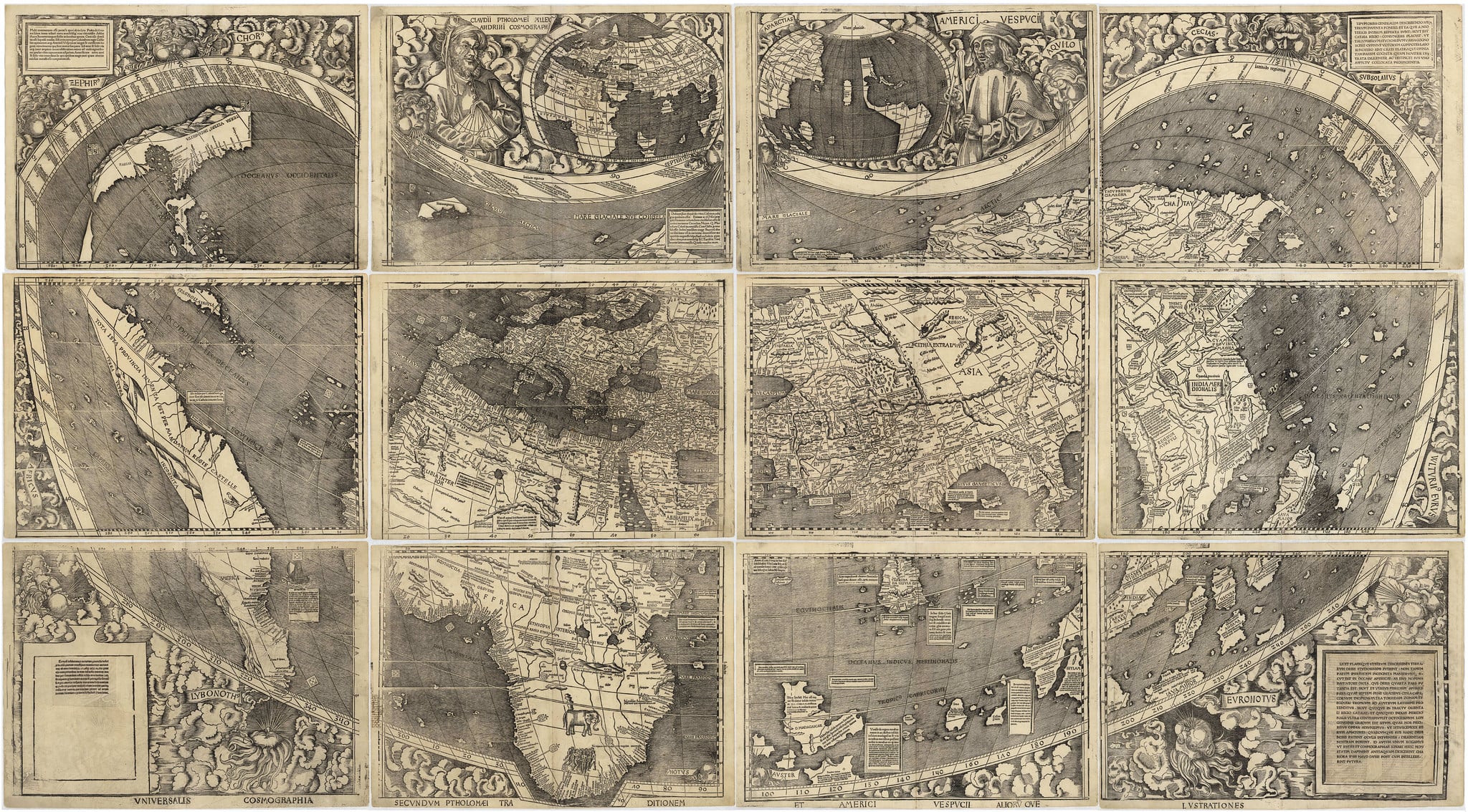
Created in 1507 – this groundbreaking world map somehow labeled a landmass “America” a full year before Amerigo Vespucci’s name became widely associated with the continent. Martin Waldseemüller couldn’t possibly have known his casual naming choice would stick permanently.
The map also showed South America with surprising accuracy despite extremely limited exploration data. Perhaps most astounding, it depicted a Pacific Ocean nobody European had yet seen – Balboa wouldn’t reach those waters until 1513, six years after the map’s publication.
John Snow’s Cholera Map

Decades before germ theory gained acceptance, physician John Snow created a map in 1854 tracking London cholera cases that essentially predicted modern epidemiology. By carefully plotting outbreak locations around Broad Street, his visualization revealed clustering around a specific water pump – challenging the prevailing “miasma” theory of disease.
The map predicted what science would later confirm: contaminated water spread the illness. Snow’s approach anticipated spatial analysis techniques that wouldn’t become standard for another century.
Alfred Wegener’s Continental Drift Maps
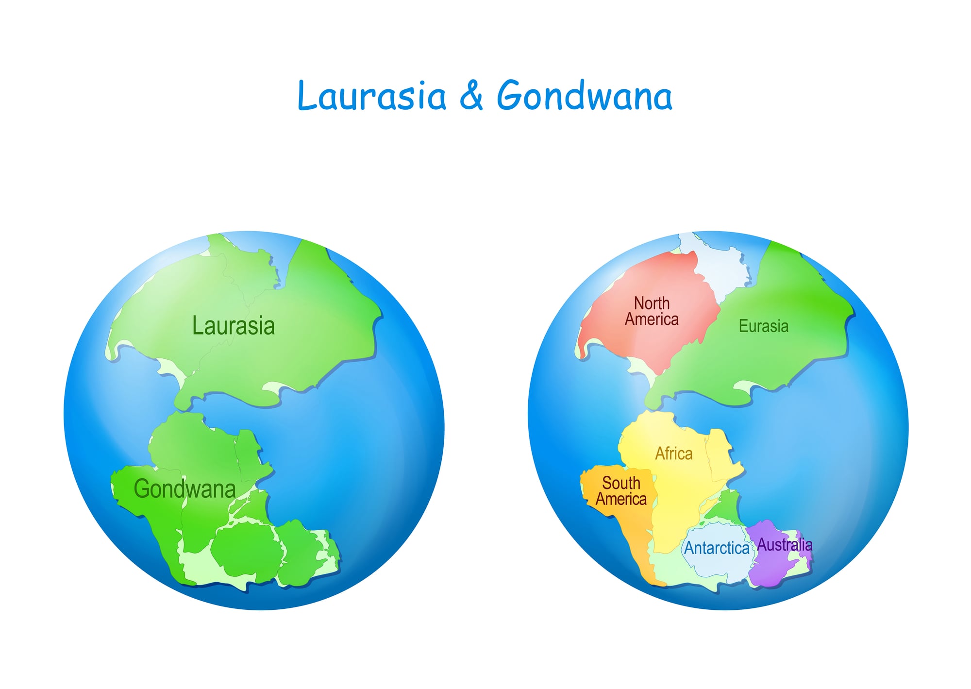
In 1912, German meteorologist Alfred Wegener published maps showing how continents might once have fit together – a theory met with widespread ridicule. His reconstructions depicted landmasses drifting apart over millions of years like pieces of a broken puzzle.
Fifty years passed before plate tectonic theory confirmed Wegener’s fundamental insight. His maps predicted geological processes nobody could detect with available technology, yet modern GPS measurements have validated his predictions to within remarkable margins of error.
Lewis Fry Richardson’s Weather Prediction Factory
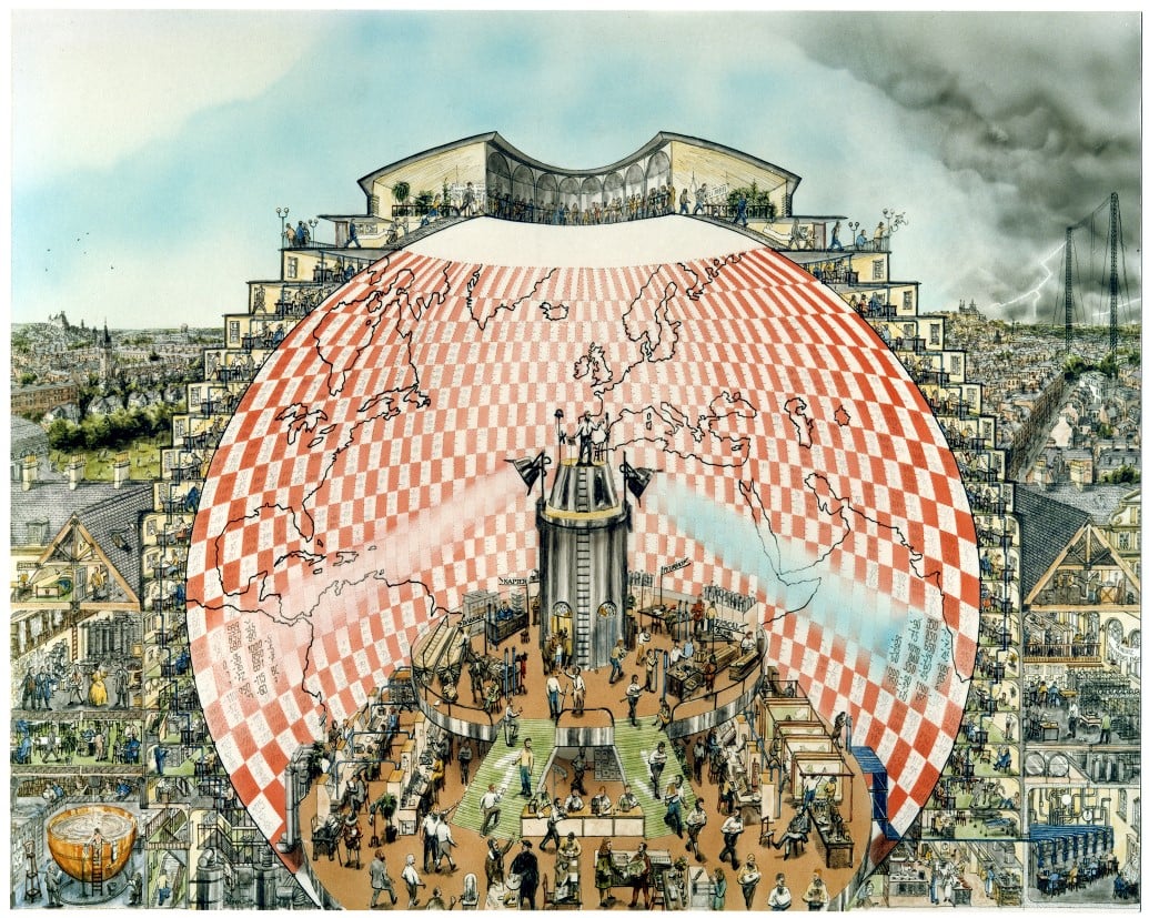
This wasn’t a traditional map, but a conceptual diagram from 1922 envisioning a vast hall where 64,000 human computers would calculate weather patterns in real-time. Richardson’s fantastical map laid out a theoretical approach to numerical weather prediction decades before digital computers made it feasible.
His basic methodology – dividing the atmosphere into a grid of calculations – forms the backbone of every modern weather forecast model. The “map” predicted computational meteorology with eerie foresight.
The British North Polar Expedition Map
When James Clark Ross led an Arctic expedition in 1831, cartographers created speculative maps of what they might discover. One particular map predicted an open polar sea beyond the ice barrier – completely wrong, yet it correctly placed several key Arctic passages that wouldn’t be confirmed for decades.
Most remarkable was its roughly accurate depiction of parts of northern Greenland that no European had yet seen. Some features matched reality so well that historians still debate whether they represent lucky guesses or unknown information sources.
Harold Fisk’s Ancient Mississippi River Maps

In 1944, geologist Harold Fisk mapped the historical courses of the Mississippi River over thousands of years – creating swirling, colorful visualizations of how the river had repeatedly changed path. The maps weren’t just historical; they predicted future flooding patterns and geological risks with surprising precision.
Areas Fisk identified as former riverbeds have indeed proven most vulnerable to modern floods. His work anticipated hydrological changes that wouldn’t become apparent until satellite imagery became available decades later.
The Ibn Battuta Global Circuit Map
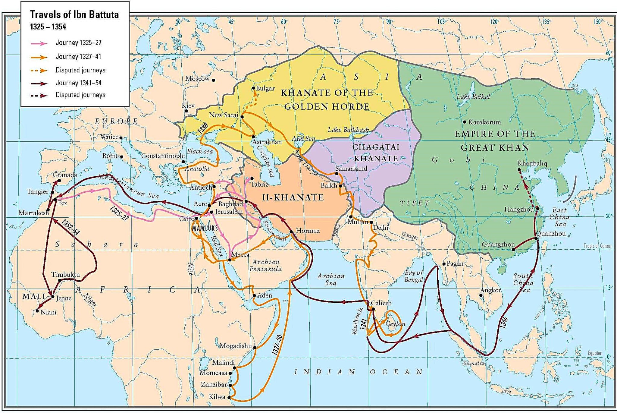
This 14th-century reconstruction of Ibn Battuta’s travels contains something remarkable – accurate geographical relationships between distant regions despite lacking modern surveying tools. The map correctly predicted coastline features in Southeast Asia and East Africa that European cartographers wouldn’t accurately document for centuries.
Some scholars believe it contains knowledge from lost maritime trading networks. Its accuracy in showing relative distances between ports seems almost impossible given the era’s navigational limitations.
Thomas Jefferson’s Western Territory Maps

Before Lewis and Clark embarked on their famous expedition, Thomas Jefferson commissioned predictive maps of western territories in 1803. Though filled with errors and mythology (including hopes for woolly mammoths), these speculative charts correctly anticipated major mountain ranges, river systems, and indigenous population centers.
Jefferson’s cartographic predictions came remarkably close to reality in identifying the continental watershed divide and major passable routes through the Rockies – despite being based on secondhand accounts and indigenous knowledge rather than direct observation.
Charles Booth’s London Poverty Maps

Between 1886 and 1903, Charles Booth created color-coded maps of London showing economic conditions street by street – an unprecedented social visualization. Beyond documenting existing conditions, these maps predicted future urban development patterns with startling accuracy.
Areas Booth coded as chronically impoverished often remained so a century later. His work effectively predicted gentrification patterns, transit development corridors, and persistent inequality zones long before urban planning emerged as a formal discipline.
Marie Tharp’s Ocean Floor Maps

In the 1950s, geologist Marie Tharp painstakingly mapped the Atlantic Ocean floor using limited sonar data – revealing a central ridge nobody had visualized before. Her maps predicted the presence of seafloor spreading and continental drift when these theories remained highly controversial.
Working with limited technology and often excluded from research vessels because of her gender, Tharp nonetheless constructed visualizations that predicted sub-oceanic features satellites would confirm decades later.
Buckminster Fuller’s Dymaxion Map

When Buckminster Fuller unveiled his unusual projection in 1943, many dismissed it as merely an odd geometric exercise. His map unfolded the globe onto a polyhedron, preserving relative sizes while distorting familiar shapes.
Though strange-looking, Fuller’s map predicted flight patterns, communication networks, and resource distribution systems that wouldn’t develop for decades. His visualization anticipated global interconnection patterns that only became obvious during the internet age.
Abu al-Idrisi’s Climate Zone Maps

This 12th-century Islamic scholar produced remarkably accurate climate zone maps that divided the Earth into regions based on environmental characteristics rather than political boundaries. Despite working nearly 900 years ago, al-Idrisi’s climate boundaries anticipated modern biome classifications with surprising precision.
His work predicted ecological relationships between distant regions that share similar conditions – a fundamental concept in modern environmental science that wouldn’t be formally established until the late 19th century.
Japanese Tsunami Stone Maps

These aren’t paper maps but stone markers placed by ancient Japanese villagers warning about tsunami danger zones. Some stones date back 600+ years with inscriptions like “Do not build below this point.”
Modern tsunami research has confirmed that these markers accurately predicted inundation zones with remarkable precision.
After the 2011 Tōhoku earthquake and tsunami, survey teams discovered communities that heeded these ancient “maps” suffered far fewer casualties than those that ignored the warnings carved in stone.
The First Global Digital Elevation Model
When satellites first mapped Earth’s surface elevations in the 1990s, scientists created comprehensive digital models predicting flood zones, landslide risks, and terrain characteristics. These early computerized topographical maps anticipated disaster patterns with uncanny accuracy.
Areas flagged as high-risk have consistently experienced more frequent catastrophic events as climate patterns have shifted. The models effectively predicted which coastal regions would face greatest inundation threats decades before sea level rise became widely accepted as inevitable.
Cartographic Foresight

Maps have always existed in a curious space between documentation and imagination – between recording what is known and projecting what might be there. The most prescient examples remind us that skilled observation, pattern recognition, and logical extension can sometimes reveal future realities before they fully materialize.
These cartographic predictions weren’t magic or mysticism; they represented the culmination of careful study combined with bold hypotheses about how geographic systems might evolve. What makes these maps truly remarkable isn’t just their accuracy but their influence on human development.
By visualizing potential futures, maps help shape the very outcomes they predict. Modern predictive mapping continues this tradition – from climate change projections to urban growth models – creating visual hypotheses about tomorrow’s world that may prove as prophetic as those crafted by cartographers of the past.
More from Go2Tutors!

- The Romanov Crown Jewels and Their Tragic Fate
- 13 Historical Mysteries That Science Still Can’t Solve
- Famous Hoaxes That Fooled the World for Years
- 15 Child Stars with Tragic Adult Lives
- 16 Famous Jewelry Pieces in History
Like Go2Tutors’s content? Follow us on MSN.