17 Photos of New York City Before It Became a Megacity
New York City wasn’t always the towering metropolis of steel and glass that dominates the horizon today. Before the skyscrapers pierced the clouds and millions of people called it home, Manhattan was a collection of small neighborhoods, farmland, and waterfront communities that bore little resemblance to the city we know now.
These historical photographs capture a different New York—one where horses shared the streets with early automobiles, where Central Park was still taking shape, and where the famous skyline existed only in the dreams of ambitious architects.
Lower Manhattan’s Cobblestone Streets
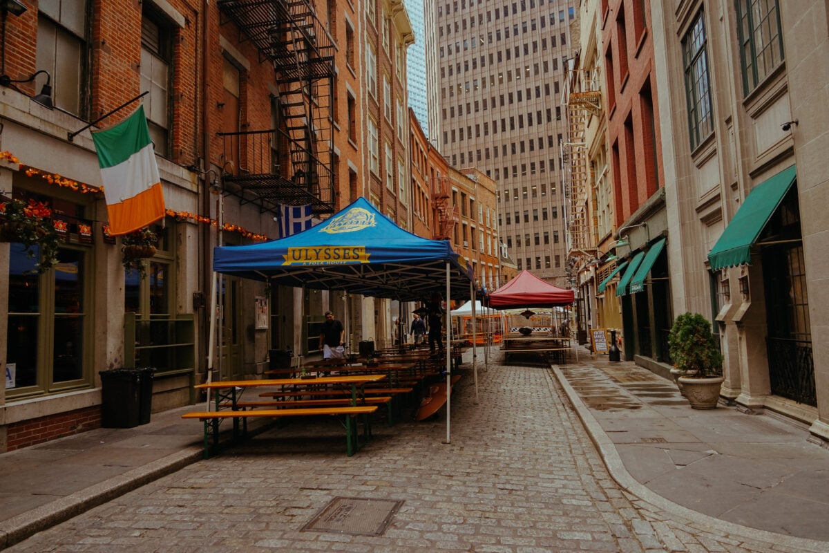
The narrow cobblestone streets of lower Manhattan tell the story of a city built for walking, not driving. Stone Street, one of the oldest continuously inhabited areas in the city, was lined with modest buildings that housed merchants and their families.
The streets were barely wide enough for a horse-drawn cart, and the buildings rarely exceeded four stories. This wasn’t the financial district yet—just a working neighborhood where people lived above their shops and knew their neighbors by name.
Central Park Under Construction
The creation of Central Park was nothing short of ambitious—and completely artificial, which makes it all the more remarkable when you consider what they were working with (basically swampland and rocky outcroppings that nobody wanted). Frederick Law Olmsted and Calvert Vaux didn’t just design a park; they engineered an entirely new landscape where one had never existed, moving enough earth to fill several city blocks and planting trees that would take decades to mature.
The early photographs show a raw, unfinished space. Workers with shovels and wheelbarrows.
And yet, even in its incomplete state, you could see the vision taking shape—the gentle curves of pathways that would one day welcome millions of visitors, the carefully planned sight lines that would make 843 acres feel both intimate and grand.
The Original Penn Station

Penn Station was a cathedral. Not metaphorically—literally.
The original structure, completed in 1910, featured soaring arches and columns that made every arrival feel ceremonial. Travelers descended into the main concourse through staircases that belonged in a palace, not a train station.
The destruction of this architectural masterpiece in 1963 remains one of the city’s greatest cultural losses, but the photographs preserve what was once considered impossible to lose.
Brooklyn Bridge Construction

Building the Brooklyn Bridge was audacious to the point of being foolish. Nobody had attempted a suspension bridge of this scale before, and the construction claimed lives—including that of the original designer, John Augustus Roebling, who died from tetanus after his foot was crushed while surveying the bridge site.
His son Washington took over, only to be paralyzed by decompression sickness from working in the underwater caissons. So his wife Emily became the first woman field engineer, effectively running the project for over a decade.
The construction photos show the massive stone towers rising from the East River, cables being spun between them, and workers suspended high above the water with nothing but their courage and some rope keeping them alive.
Fifth Avenue’s Millionaire’s Row
Fifth Avenue between 50th and 96th Streets was where America’s richest families built their palaces—and they were palaces, not houses. The Astors, Vanderbilts, and Carnegies commissioned architects to create European-style mansions that occupied entire city blocks.
These weren’t just homes; they were statements of power that said money could buy anything, including the ability to live like royalty in a democratic nation. Most of these mansions have been demolished, replaced by apartment buildings and commercial spaces, making the surviving photographs feel like glimpses into a lost world of extreme wealth.
Times Square as Longacre Square

Before it became the neon-lit tourist destination known worldwide, Times Square was called Longacre Square—a relatively quiet intersection where Broadway crossed Seventh Avenue. The area was known for its carriage trade, with harness shops and horse stables serving the transportation needs of the city.
When The New York Times moved its headquarters to the newly constructed Times Building in 1904, the square was renamed in the newspaper’s honor, but the transformation into the entertainment district we know today was still decades away.
Ellis Island Immigration Station
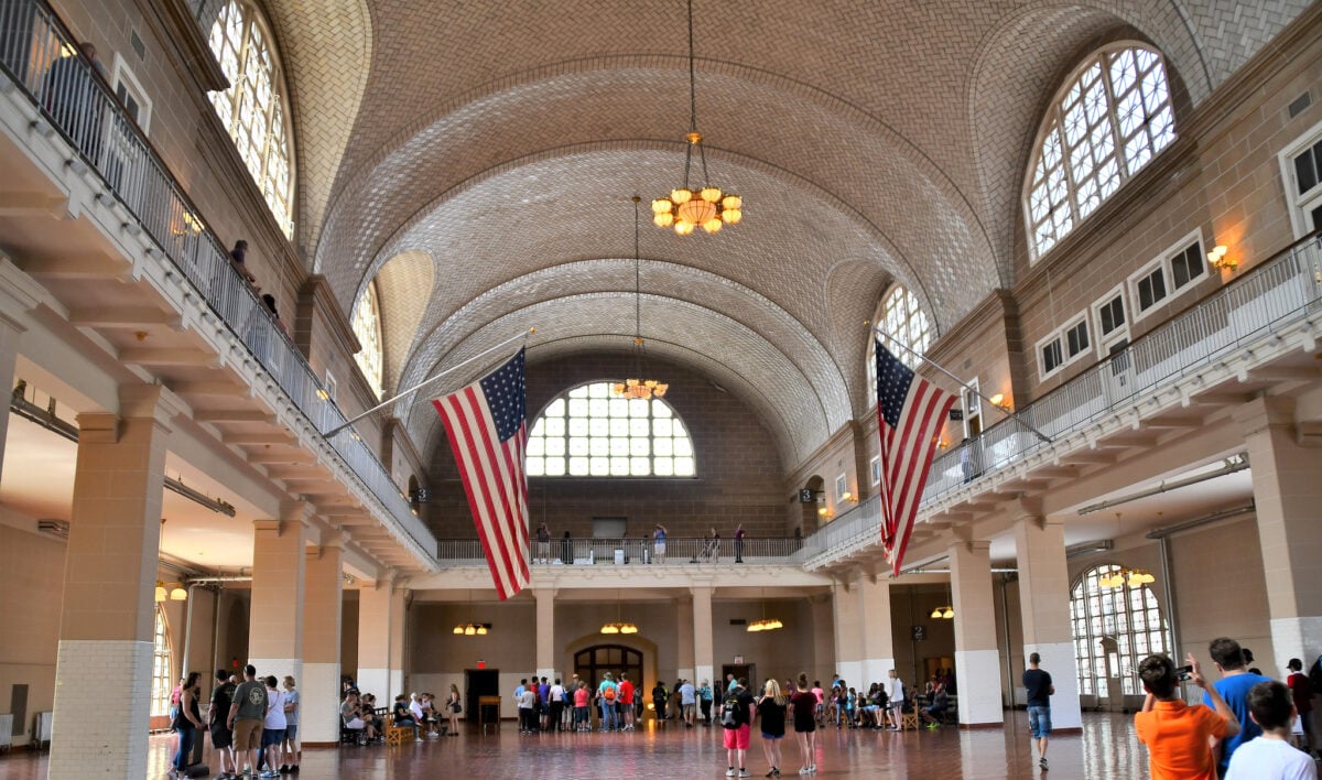
Ellis Island processed twelve million immigrants between 1892 and 1954, making it the entry point for nearly half of all Americans who can trace their ancestry to someone who arrived during that period. The photographs from the station’s early years show families clutching their possessions, waiting in long lines, undergoing medical examinations that would determine their fate in America.
These weren’t tourist snapshots—they were documentation of one of the largest human migrations in history, captured one person at a time.
The Dakota Building in Isolation
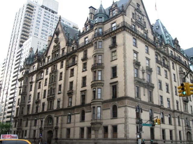
When the Dakota apartment building was completed in 1884, it stood virtually alone on the Upper West Side, surrounded by empty lots and scattered farmhouses—so isolated that people joked residents would need a passport to visit such a remote location (hence the building’s frontier-inspired name). The ornate German Renaissance-style structure seemed absurdly grand for its barren surroundings, like a European palace accidentally dropped into the American countryside. But Edward Clark, the building’s developer, was betting on the city’s northward expansion.
The early photographs show the Dakota as a lonely giant, its elaborate facade facing empty streets that wouldn’t see significant development for another two decades. Clark’s gamble paid off spectacularly—the building became one of the most prestigious addresses in the city, proving that sometimes the best real estate strategy is simply being first.
Wall Street’s Narrow Canyon

Wall Street earned its name from an actual wall—a wooden barrier built by Dutch colonists in 1653 to protect New Amsterdam from attacks by Native Americans and the British. The street that developed along this fortification was narrow and winding, following the path of the original wall rather than any logical city planning.
Early photographs show a cramped canyon of buildings where sunlight barely reached street level, even at midday. The financial district’s claustrophobic layout wasn’t designed—it just happened, one building at a time.
Coney Island’s Early Amusement Parks
Coney Island was America’s first major amusement destination, but it started as something much simpler—a seaside resort where city dwellers could escape the summer heat. The early amusement parks, including Luna Park and Dreamland, were architectural fantasies built from wood and plaster, designed to transport visitors to imaginary worlds for the price of admission.
These weren’t the corporate theme parks of today; they were handmade wonderlands created by entrepreneurs who understood that people would pay good money to forget their troubles for a few hours.
The Flatiron Building’s Unusual Shape

The Flatiron Building’s triangular shape wasn’t an architectural statement—it was geometry forced by geography. When the building was completed in 1902, the wedge-shaped lot at the intersection of Broadway, Fifth Avenue, and 23rd Street created an unusual design challenge that architect Daniel Burnham solved by embracing the constraints rather than fighting them.
The result was a building that looked like the prow of a ship sailing north through the city. Early photographs show curious crowds gathering to watch construction, unsure whether this odd-shaped tower would stand or topple.
Grand Central Terminal Construction

Grand Central Terminal (not Station—the distinction matters to New Yorkers) was built to be more than a transportation hub; it was designed to be a civic monument that would rival the great train stations of Europe (though it actually ended up surpassing most of them in both scale and grandeur). The construction photographs reveal the massive excavation required to create the terminal’s multi-level design, with trains arriving on two levels below street level while the main concourse soared 125 feet above.
But the real engineering marvel wasn’t what you could see—it was the electrification of the entire system, making Grand Central the first major train terminal in the world to ban steam locomotives. The constellation painted on the main concourse ceiling would become one of the most photographed ceilings in America, though few visitors realize the stars are actually backwards, showing the constellations as they would appear from outside the celestial sphere rather than from Earth.
Lower East Side Tenements
The tenement buildings of the Lower East Side weren’t designed for comfort—they were designed for profit. Landlords packed as many families as possible into narrow buildings, creating living conditions that shocked even the city’s toughest social reformers.
The photographs taken by Jacob Riis and other documentary photographers revealed apartments where entire families lived in single rooms without windows, where children played in hallways that never saw sunlight. These images helped drive the housing reform movement that would eventually improve conditions, but they also captured a way of life that defined the immigrant experience for millions of New Yorkers.
Washington Square Park’s Origins
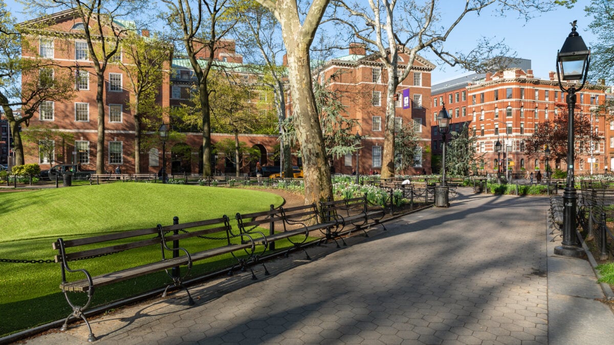
Washington Square Park began as a potter’s field—a burial ground for the poor and unknown dead of the city. An estimated 20,000 people were buried there before it was converted to a public park in 1827. The famous Washington Square Arch wasn’t part of the original design.
A temporary wooden arch was built in 1889 to celebrate the centennial of George Washington’s inauguration, and proved so popular that a permanent marble arch was completed in 1892 to replace it. Early photographs show a much smaller park surrounded by modest row houses, before the area became the bohemian enclave that would attract artists, writers, and revolutionaries.
The High Line as Working Railroad

The High Line wasn’t always an elevated park beloved by tourists and real estate developers—it was a working freight railroad that carried goods to and from the warehouses and factories of Manhattan’s West Side. Built in the 1930s to remove dangerous train traffic from street level, the elevated tracks allowed trains to run directly into buildings, loading and unloading cargo on upper floors.
The railroad operated until 1980, when trucking had made freight trains obsolete in Manhattan. For decades, the abandoned tracks were slowly reclaimed by wild plants and urban wildlife, creating an accidental green space that inspired the park we know today.
Brooklyn Heights Promenade Before the BQE
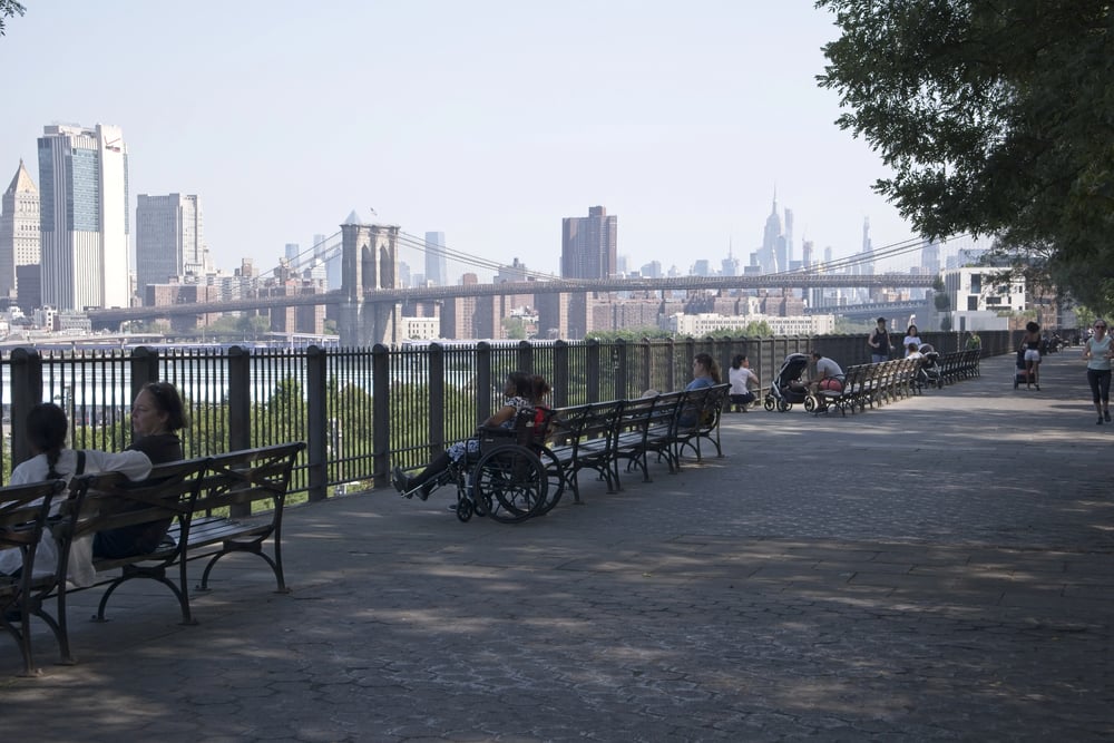
Brooklyn Heights has always offered spectacular views of Manhattan, but the famous Promenade wasn’t built for sightseeing—it was built to hide a highway. When the Brooklyn-Queens Expressway was constructed in the 1940s, it threatened to destroy the historic neighborhood’s character.
The compromise was to build the highway at the base of the bluff and construct the Promenade on top, preserving both the neighborhood and its views. Before the highway’s construction, the waterfront was lined with warehouses and piers, and residents had to walk to the edge of their backyards to see the harbor.
Staten Island’s Rural Landscape

Staten Island remained largely rural well into the 20th century, more connected to New Jersey than to the rest of New York City. The island was home to farms, small villages, and summer estates for wealthy Manhattanites seeking country air.
The Verrazzano-Narrows Bridge didn’t open until 1964, finally providing a direct connection to Brooklyn and spurring the suburban development that would transform the island. Early photographs show a pastoral landscape of rolling hills and farmland that seems impossible to reconcile with the densely populated borough it would become.
Looking Back Through Time
These photographs capture more than buildings and streets—they preserve the moment when New York City was still becoming itself. The horse-drawn carriages and gas streetlights seem quaint now, but they were simply the technology of their time, just as reliable and modern as anything we use today.
Each image holds the DNA of the megacity that was to come, showing how neighborhoods grew organically around transportation hubs, how immigrants transformed empty lots into thriving communities, and how a collection of separate boroughs gradually became the unified metropolis that would define urban life for the rest of the world.
More from Go2Tutors!

- The Romanov Crown Jewels and Their Tragic Fate
- 13 Historical Mysteries That Science Still Can’t Solve
- Famous Hoaxes That Fooled the World for Years
- 15 Child Stars with Tragic Adult Lives
- 16 Famous Jewelry Pieces in History
Like Go2Tutors’s content? Follow us on MSN.