Old Navigation Methods That Influenced Exploration
Before GPS satellites and smartphone apps, explorers had to rely on their wits, the stars, and some surprisingly clever tools to find their way across unknown lands and vast oceans. These early navigation methods weren’t just about getting from point A to point B.
They shaped which routes sailors took, which lands got discovered first, and even which empires rose to power. The techniques developed centuries ago laid the groundwork for every major voyage of discovery, from crossing the Pacific to mapping entire continents.
Let’s look at the navigation methods that made exploration possible and changed the world forever.
Reading the stars at night

Ancient sailors turned the night sky into their personal road map, using stars as fixed reference points to guide their journeys. The North Star became especially valuable for navigators in the Northern Hemisphere because it stays nearly stationary while other stars appear to rotate around it.
Experienced sailors could determine their latitude by measuring the angle between the horizon and specific stars. Arab navigators became masters at this technique, creating detailed star catalogs that European explorers later borrowed and expanded.
This method allowed ships to cross open oceans without losing their way, though cloudy nights could leave crews sailing blind for days.
The magnetic compass

Chinese inventors created the first magnetic compasses around the 11th century, initially for fortune-telling before anyone realized their navigation potential. Europeans adopted this technology in the 12th century and immediately recognized how it could change sea travel forever.
The compass needle always pointed north, giving sailors a reliable direction even when fog obscured the sun or storms blocked the stars. This simple tool gave captains the confidence to venture farther from coastlines into open water.
Without the compass, the Age of Exploration would have started much later, if at all.
Using a lead line for depth

Sailors dropped weighted ropes called lead lines into the water to measure depth and avoid running aground on hidden obstacles. The bottom of the lead weight had a hollow space filled with tallow or grease that picked up samples of the seafloor.
Experienced navigators could identify their location by feeling whether the sample contained sand, mud, shells, or rocks. This method helped ships navigate tricky coastal waters and river entrances where maps were unreliable or nonexistent.
Captains kept detailed records of depth measurements that future sailors used like underwater maps.
Dead reckoning calculations

Navigators estimated their position by tracking the direction traveled, the distance covered, and the time elapsed since their last known location. This method required keeping careful records in a logbook and making constant calculations based on the ship’s speed.
Sailors measured speed by throwing a piece of wood overboard and timing how long it took the ship to pass it. Dead reckoning worked reasonably well for short trips but errors accumulated over time, sometimes putting ships hundreds of miles off course.
Despite its limitations, this technique remained a primary navigation method well into the 20th century.
The astrolabe

Islamic scholars perfected the astrolabe, an intricate brass instrument that measured the angle of celestial bodies above the horizon. Portuguese sailors adapted this tool for maritime use in the 15th century, creating a simpler version that worked on rocking ship decks.
Navigators used it primarily to determine latitude by measuring the sun’s height at noon or certain stars at night. The calculations required some mathematical knowledge, so ships often carried specialists called masters who handled these measurements.
This instrument helped Portuguese explorers chart the African coast and eventually reach India by sea.
Portolan charts

Medieval sailors created portolan charts, detailed coastal maps covered with compass roses and criss-crossing lines called rhumb lines. These charts showed accurate coastlines and distances between ports but had limited information about the open ocean.
Sailors used them alongside compasses to plot courses between harbors throughout the Mediterranean and later the Atlantic coast. The charts got passed down through generations of mariners, with each voyage adding new details and corrections.
They represented accumulated knowledge from hundreds of sailors rather than theoretical geography from scholars.
The cross-staff

This T-shaped wooden tool helped sailors measure the angle between the horizon and celestial bodies with decent accuracy. Navigators held the long staff against their cheek and slid the crosspiece until it aligned with both the horizon and a star or the sun.
The position of the crosspiece on the marked staff revealed the angle, which could then be used to calculate latitude. Using this instrument required looking directly at the sun, which damaged the eyes of countless sailors over the centuries.
Despite this serious drawback, the cross-staff remained popular because it was cheap to make and fairly reliable.
Following bird migrations

Polynesian navigators watched bird behavior to find land masses beyond the visible horizon in the vast Pacific Ocean. Certain seabirds fly out to feed during the day but return to land each evening, so sailors followed them at dusk to find islands.
The presence of specific bird species also indicated how far away land might be, since different birds venture different distances from shore. Norse sailors used ravens in the North Atlantic, releasing them to see which direction they flew toward land.
This biological navigation system worked surprisingly well in regions where islands were scattered across enormous distances.
Reading wave patterns

Pacific Island navigators developed an incredibly sophisticated system for detecting land by feeling how waves moved and intersected. Ocean swells bend and reflect when they encounter islands, creating distinct patterns that experienced navigators could sense through the motion of their canoes.
Marshall Islanders created stick charts, physical maps made from coconut fronds and shells that represented these wave patterns around different islands. This knowledge took years to master and was passed down through careful teaching and practice.
European sailors who first encountered these navigators could hardly believe they were crossing thousands of miles of open ocean without instruments.
The backstaff

English navigator John Davis invented this improved version of the cross-staff in 1594, solving the problem of staring at the sun. Users turned their back to the sun and lined up shadows cast by the instrument with the horizon.
This design was safer for the eyes and actually produced more accurate measurements than its predecessor. The backstaff became standard equipment on English ships throughout the 17th and early 18th centuries.
Its success showed how even small improvements in navigation tools could give one nation an advantage in exploration and trade.
Pilot books and rutters

Experienced sailors compiled written guides called rutters that described routes, landmarks, hazards, and navigation tips for specific regions. These books contained information about prevailing winds, currents, safe anchorages, and distinctive coastal features that helped identify locations.
The Portuguese and Spanish guarded their rutters as state secrets because they represented valuable strategic knowledge. Pirates and rival nations went to great lengths to steal these books, knowing they could unlock access to profitable trade routes.
A good rutter could mean the difference between a successful voyage and a disaster at sea.
Thenocturnal

This specialized clock-like device helped sailors tell time at night by measuring the rotation of stars around the North Star. Navigators needed to know the time to make accurate celestial navigation calculations, but mechanical clocks didn’t work well on ships.
The nocturnal solution solved this problem by using the position of stars, particularly those in the Big Dipper, which rotates predictably around Polaris. Users aligned different parts of the instrument with specific stars and read the time off a marked dial.
This clever tool remained in use from the 15th century until the 1800s when better chronometers became available.
Lunar distance method

Astronomers developed tables that predicted the moon’s position among the stars at specific times, allowing navigators to determine longitude by measuring the angle between the moon and certain stars. This method required complex calculations and very accurate angle measurements, making it challenging to use on a moving ship.
The British Board of Longitude offered a huge prize for solving the longitude problem, which eventually led to both improved lunar tables and the development of accurate chronometers. Despite being difficult, the lunar distance method was the first reliable way to determine longitude at sea.
Expeditions like Captain Cook’s voyages used this technique to create accurate maps of the Pacific.
Measuring wind and currents

Sailors learned to predict their position by understanding how prevailing winds and ocean currents affected their speed and direction. The trade winds blow consistently in certain patterns that ships used to cross the Atlantic efficiently.
Ocean currents like the Gulf Stream could add or subtract several miles per hour from a ship’s speed depending on direction. Navigators factored these forces into their dead reckoning calculations, though currents were harder to account for than winds.
Knowledge of these patterns determined which routes sailors chose and how quickly they could complete voyages.
The sextant
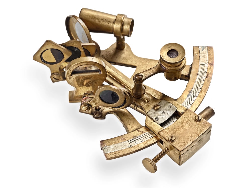
This precision instrument replaced earlier angle-measuring tools in the mid-18th century with a design that was both more accurate and easier to use. The sextant used mirrors to bring two objects into alignment, allowing navigators to measure angles without staring at the sun.
Its accuracy made celestial navigation reliable enough to determine position within a few miles rather than dozens of miles. British and American ships adopted sextants quickly, giving them an advantage in long-distance trade and exploration.
This tool became so essential that naval officers trained extensively in its use well into the modern era.
Indigenous coastal knowledge

Coastal communities understood their seas better than any chart made by Europeans. Where rivers allowed boats through, which anchorages stayed calm during storms, or spots hiding sharp reefs – locals had answers.
Survival of foreign missions hinged on hiring skilled wayfinders from nearby villages. Spain’s takeover in the Philippines worked out thanks to locals familiar with seasonal winds and passable channels.
Bits of this wisdom showed up later in European charts and logbooks, yet those who shared it seldom got mentioned.
The marine chronometer

John Harrison, an English clock guy, worked many years on building a timepiece tough enough to handle ocean trips – swinging temps, damp air, or rocking waves didn’t throw it off. Instead of guessing, sailors now used this device to pin down longitude by checking midday sun against the hour back home, say in Greenwich.
Thanks to that fix, the old headache about finding east-west spots at sea just faded away. With these clocks onboard, vessels knew exactly where they were, which made voyages safer and charts way more trustworthy.
Ditching guesswork and stars, crews started relying on precise timing; that shift kicked off a chain ending in tools we use today, like GPS.
Why older ways still count

Nowadays, seafarers or aviators pick up old-school wayfinding tricks just in case gadgets stop working. Long-ago travelers used clever thinking to tackle tough challenges using basic gear but sharp eyes.
Figuring out how discovery relied on navigating tools reveals why particular cultures grew at specific times and which paths turned crucial. Those approaches show something else – that pushing into uncharted areas takes guts along with hands-on know-how.
Next time a GPS leads someone somewhere, remember that tech traces back straight to an ancient mariner judging star positions with a piece of carved wood.
More from Go2Tutors!

- The Romanov Crown Jewels and Their Tragic Fate
- 13 Historical Mysteries That Science Still Can’t Solve
- Famous Hoaxes That Fooled the World for Years
- 15 Child Stars with Tragic Adult Lives
- 16 Famous Jewelry Pieces in History
Like Go2Tutors’s content? Follow us on MSN.