Places Shaped by Unusual Geological Events
The Earth has been doing strange things for a very long time. Volcanoes punching through ocean floors, acids dissolving limestone into impossible shapes, mineral-rich water painting cliffsides in colors that look computer-generated.
Most of it happened quietly, over millions of years, with no audience. But you can still go see the results. These are some of the places where geology got genuinely weird — and left something worth travelling to.
The Wave, Arizona, USA
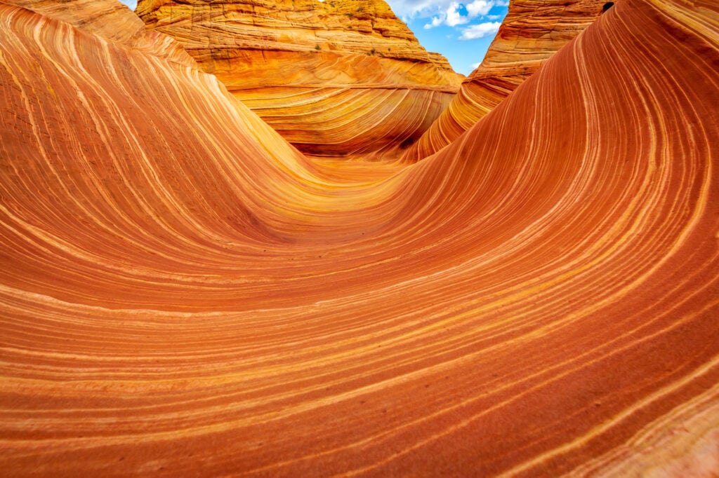
Tucked inside the Vermilion Cliffs National Monument in the American Southwest, The Wave is a sandstone formation that looks like someone poured two rivers of rock into each other and froze them mid-collision. The swirling, layered patterns come from ancient sand dunes that were buried, compressed, and then slowly exposed again by erosion over roughly 190 million years.
The colors shift from rust to cream to pink depending on the hour and the light. Access is deliberately limited — only 64 people are allowed in per day — which tells you something about how fragile the place actually is.
Waitomo Glowworm Caves, New Zealand

Below the green hills of the Waikato region, a network of limestone caves winds through the dark. The caves themselves formed the usual way — water dissolving rock over centuries — but what happens inside them is less expected.
Thousands of larvae from a species of fungus gnat cover the cave ceilings and emit a cold blue-green light to lure prey. From a boat on the underground river, the ceiling looks like a sky full of stars that someone moved indoors.
The geological setting created the perfect dark, humid environment for this to happen, and it’s been going on long enough that the ecosystem is fully established.
Fly Geyser, Nevada, USA

Fly Geyser wasn’t made entirely by nature. In 1964, a geothermal energy company drilled a well, hit superheated water, and abandoned the project. The well was improperly capped, and the pressurized water found its way out.
Over the following decades, dissolved minerals in the water built up around the opening, creating a cone that now sprays water several feet into the air and is covered in vivid green and red algae. It sits on private land in the Black Rock Desert, and the colors are striking enough that photographs of it regularly get mistaken for digital art.
Pamukkale, Turkey
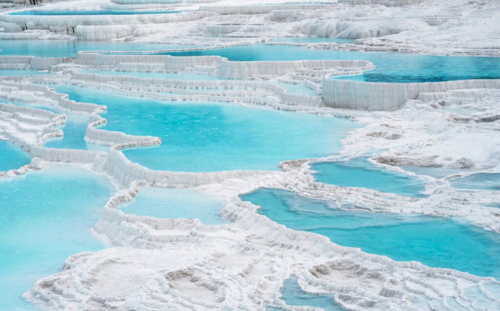
Pamukkale means “cotton castle” in Turkish, which is an oddly gentle name for something that looks this extreme. Hot springs rich in calcium carbonate flow down a hillside, and as the water cools and evaporates, it deposits white mineral terraces.
Over time, these terraces formed a cascading series of shallow pools stepping down the slope, each one rimmed in white and filled with milky blue-green water. The site has been used as a spa since Roman times — the ruins of the ancient city of Hierapolis sit directly above it.
Parts of the terraces have been damaged by tourist footwear and water diversion over the years, and access is now restricted to preserve what’s left.
The Door to Hell, Turkmenistan
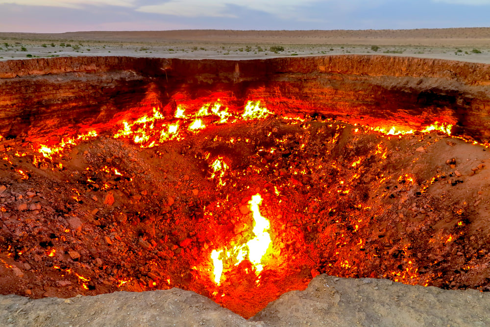
In 1971, Soviet geologists drilled into what they thought was an oil field in the Karakum Desert. The ground collapsed into a crater about 70 meters wide.
To prevent the release of natural gas, they lit it on fire, expecting it to burn out in a few weeks. It has been burning continuously ever since.
The crater glows at night and can be seen from miles away. The Turkmen government has talked about extinguishing it, partly to recover the gas for economic use, but as of now the fire keeps burning.
Locals call it the Door to Hell. Scientists call it the Darvaza gas crater.
Either way, it’s one of those places where the scale of what you’re looking at takes a moment to register.
Salar de Uyuni, Bolivia

At over 10,000 square kilometers, the Salar de Uyuni is the world’s largest salt flat. It sits on the Altiplano at about 3,600 meters above sea level and was formed when a series of prehistoric lakes evaporated, leaving behind a thick crust of salt.
During the rainy season, a thin layer of water covers the surface and creates a near-perfect mirror effect — the sky reflects so completely that the horizon disappears, and you can’t easily tell where the ground ends and the sky begins. Beneath the salt crust, the world’s largest known lithium reserve sits waiting.
The flat is also dotted with islands of ancient coral, which are the remnants of the lake beds that once covered the region.
Giant’s Causeway, Northern Ireland

About 60 million years ago, volcanic activity pushed basalt lava through chalk beds. As the lava cooled, it contracted and fractured into columns.
The result is a landscape of roughly 40,000 interlocking basalt columns, most of them hexagonal, fitted together along the coast of County Antrim with a precision that looks deliberate. The columns range from a few centimeters to about 12 meters tall.
Standing among them, there’s something slightly disorienting about the geometry — it looks like a tiled floor that someone laid at the edge of the Atlantic and left unfinished. Irish mythology has its own explanation involving a giant named Finn McCool, which is honestly just as satisfying.
Chocolate Hills, Philippines

The island of Bohol in the Philippines has around 1,700 almost perfectly conical hills scattered across about 50 square kilometers. They’re covered in grass that turns brown during the dry season, which is where the name comes from.
The leading geological explanation is that they formed from marine limestone that was pushed above sea level, then shaped by rainwater into mounds over millions of years. But geologists still debate the specifics.
Each hill is remarkably similar in shape and height, which is part of what makes the landscape look staged. From above, they stretch to the horizon in every direction like a field of identically-sized bumps.
Vale da Lua, Brazil

In the Chapada dos Veadeiros plateau in central Brazil, a river has been carving through quartz rock for what geologists estimate is around 1.8 billion years. The result is a series of natural pools, channels, and curved stone formations polished smooth by the current.
The quartz gives the rock a crystalline quality, and the water moving through it catches light differently than it would in ordinary stone. The formations are old enough that the quartz itself predates much of the rest of the planet’s surface geology.
Walking through Vale da Lua on a clear day feels like walking through something that was made rather than worn.
Zhangye Danxia Landform, China
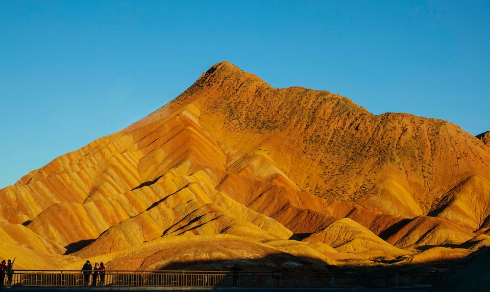
The Danxia landform in Gansu Province looks like a landscape rendered in layers of paint — horizontal bands of red, orange, yellow, and green stacked across eroded rock faces. The colors come from different mineral deposits laid down in sandstone over about 24 million years, then exposed as the rock eroded away.
The patterns shift depending on the angle of sunlight, which is why the place attracts photographers at dawn and dusk specifically. The geological term “Danxia” refers to reddish layered sedimentary rock formations, and China has several of them, but the Zhangye version is the most intensely colored.
Moeraki Boulders, New Zealand

Dotting Koekohe Beach along New Zealand’s southern shore, round stones rest half-buried in wet sand or roll gently with incoming waves. More than two meters wide in places, these hefty spheres began life deep underwater millions of years back.
Slow buildup of dissolved minerals layered themselves around small centers – pearl-like growth happening grain by grain through ages. While the tougher nodules held firm, the weaker clay-rich rock encasing them eroded away under shifting tides.
Now revealed, the ocean still chips at what remains of that softer stone, leaving behind time-worn orbs where once there was only seabed. A few lie split apart, showing a glassy emptiness inside.
Old Māori stories say these came from broken carriers of food, spilled when a huge waka tipped near land.
Richat Structure, Mauritania

You can spot the Richat Structure from orbit. About 48 kilometers wide, it looks like a bullseye in the middle of the Sahara. Seen up close, though, it feels different – more subtle.
Layers of rock, each resisting weathering in their own way, create rings of hills and dips. At first people guessed it came from a meteor strike.
Now scientists agree: it started as an uplifted bubble of earth, slowly exposed by even, radial erosion. In the flat emptiness below, astronauts found it helpful as a marker on the landscape.
When you’re actually there, its scale hides itself; you stand within its shape without seeing the whole thing.
Socotra Island, Yemen

Floating apart in the Arabian Sea, Socotra stayed cut off so long that life there followed its own path. One out of every three plants grows only on this island, nowhere else.
Standing tall among them is the dragon blood tree, its wide crown like an upside-down umbrella, oozing deep red sap if wounded. Ancient roots run under everything – rock older than time, worn by drought and solitude, shaping what could survive.
Life bent oddly here, forced by heat, wind, and separation. Out there, the land feels alien – pale shores stretch beneath peaks wearing odd umbrella-shaped trees, thick with giant succulents.
Not old rock alone made this place, but long separation, weather patterns slow-cooked over time. What you see now came from those three things mixing in silence.
Ground Makes Its Own Moves

What lasts millions of years bends how we think about now. Some spots needed ages beyond feeling – a stretch here, deep quiet there.
Time moves slowly like breath held too long. This slowness shapes why you feel small standing inside such space.
Not every view tells you who you are. A fire glows in Turkmenistan where gas escaped through a forgotten gap.
Not far below the surface, rocks off New Zealand’s coast swell over time like quiet breaths. What looks flat and empty in Bolivia once held deep lakes now vanished into the air.
These spots did not form by plan or purpose but by shifts too slow to see. Though they seem complete, each remains caught mid-change even today.
More from Go2Tutors!

- The Romanov Crown Jewels and Their Tragic Fate
- 13 Historical Mysteries That Science Still Can’t Solve
- Famous Hoaxes That Fooled the World for Years
- 15 Child Stars with Tragic Adult Lives
- 16 Famous Jewelry Pieces in History
Like Go2Tutors’s content? Follow us on MSN.