Scariest Roads to Drive on
Some roads test your nerves more than your driving skills. They twist along cliff edges, climb through clouds, or disappear into tunnels carved through solid rock.
Drivers who’ve traveled these routes come back with stories that sound exaggerated until you see the roads yourself. The fear is real, but so is the strange pull to experience them.
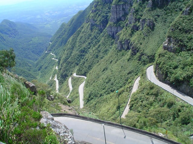
The Stelvio Pass Switchbacks

Forty-eight hairpin turns stack on top of each other in the Italian Alps. The road climbs nearly 9,000 feet, and each turn feels sharper than the last.
You can see the next five or six switchbacks below you, which somehow makes it worse. Motorcyclists love this road. Everyone else grips the wheel a little tighter.
Winter closures happen for obvious reasons. Snow would make this stretch impossible.
Even in summer, fog rolls in without warning and turns those hairpins into guessing games.
North Yungas Road

People call it Death Road. The nickname stuck for a reason.
This Bolivian route drops from the Andes to the rainforest, and for most of the journey, you’re driving on a single-lane path carved into the mountainside. No guardrails.
Just a sheer drop that goes down hundreds of feet. Rain happens almost daily here.
The road surface turns to mud. Vehicles coming from opposite directions have to figure out who backs up.
Local drivers follow an unwritten rule—the vehicle heading downhill yields because they’re closer to the edge. That tells you everything you need to know about this road.
Crosses and memorials mark where vehicles went over. You notice them more than you want to.
Dalton Highway in Winter

Alaska’s Dalton Highway runs 414 miles through some of the emptiest terrain in North America. During winter, temperatures drop to 60 below zero.
The road turns to ice. Potholes appear without warning, hidden under snow.
Gas stations are spread 200 miles apart. If your vehicle breaks down between them, you’re in serious trouble.
Cell service doesn’t exist for most of the route. Truckers dominate this highway, and they don’t slow down for tourist vehicles.
The isolation hits you first. Then the cold.
Then the realization that help isn’t coming quickly if something goes wrong.
Trollstigen Mountain Road

Norway built this route through impossible terrain. The name translates to Troll’s Ladder, and you understand why when you drive it.
Eleven hairpin bends climb up a steep mountain face. The road is so narrow that large vehicles need to be escorted.
In some spots, two cars barely fit side by side. Waterfalls pour down the rock face right next to the road.
When it rains, the water rushes across the pavement. The views are stunning, but you can’t look at them while driving.
You’re too busy watching the road and hoping nobody’s coming around the next blind corner.
Guoliang Tunnel

Chinese villagers carved this tunnel through the Taihang Mountains by hand. They worked for five years with hammers and chisels.
The result is a passage barely wide enough for one vehicle, with rough walls and uneven surfaces. Pits in the tunnel wall serve as windows. They let in light, but they also remind you that you’re driving through the side of a mountain.
One wrong move and you’re off the edge. The tunnel stretches for about three-quarters of a mile, and every foot of it demands complete attention.
Tour buses somehow navigate this route. Watching them squeeze through makes you question the definition of “safe passage.”
James Dalton Highway Summer Conditions

The same Alaskan highway that terrifies drivers in winter presents different dangers in summer. The permafrost thaws.
The road surface turns soft and unstable. Trucks kick up rocks that shatter windshields.
Dust clouds make it impossible to see more than a few feet ahead. Flat tires happen constantly.
Bring multiple spares. The wildlife adds another layer of concern—bears, moose, and caribou wander onto the highway.
Hitting a moose at highway speed is often fatal for everyone involved. And you still have those 200-mile gaps between services.
Karakoram Highway

This road connects Pakistan and China through some of the highest mountain passes in the world. Parts of it sit at elevations above 15,000 feet.
Landslides are common. Rockfalls happen without warning.
The highway follows old trading routes, but modern engineering hasn’t made it much safer. Sections of road simply wash away during monsoon season.
Repairs happen slowly. Drivers often have to wait days for a path to reopen.
The views are incredible. The Hunza Valley looks like something from a fantasy novel.
But you’re too busy watching for falling rocks to appreciate the scenery properly.
Zoji La Pass
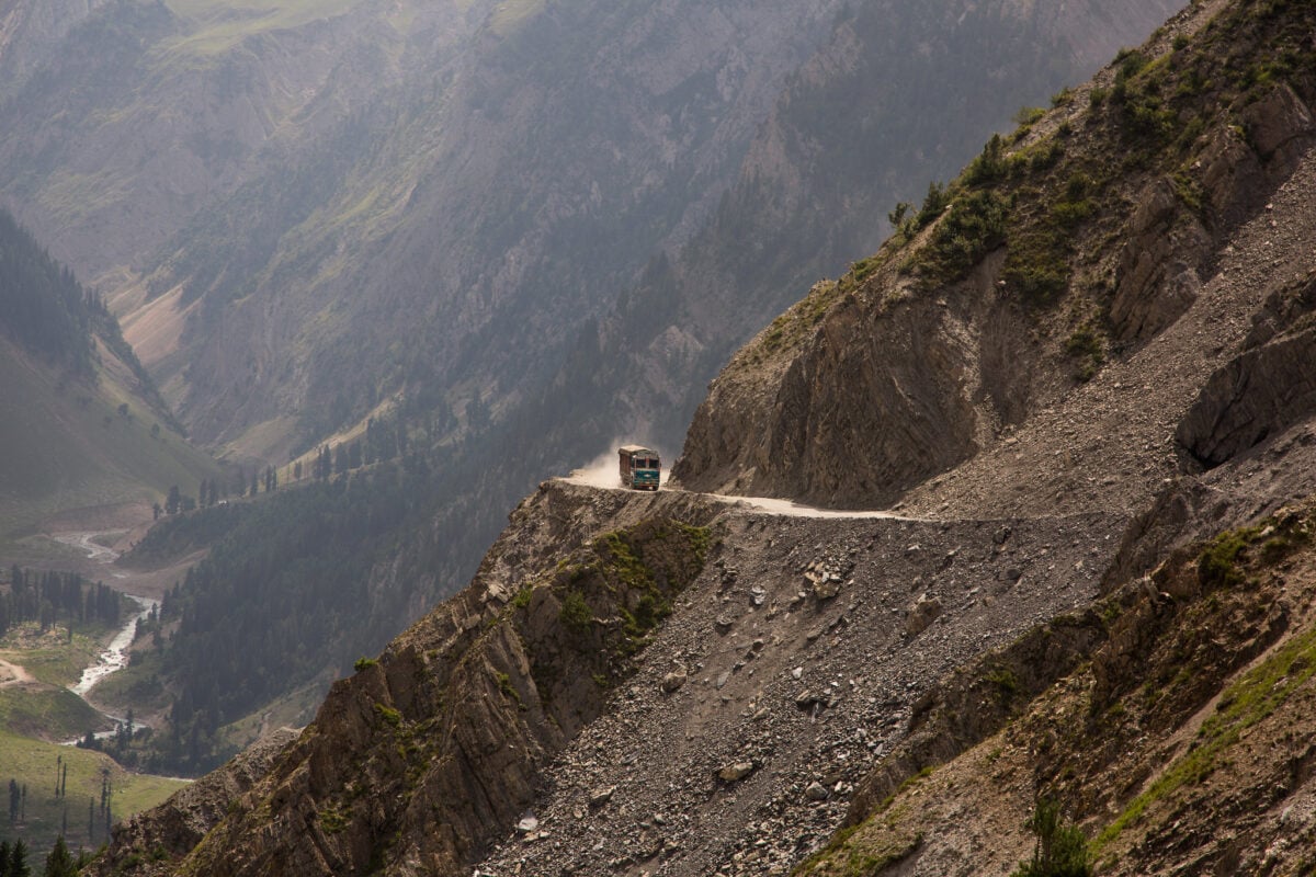
This Indian mountain pass closes six months every year because of snow. When it’s open, it serves as the only land connection between Kashmir and Ladakh.
Single-lane sections require traffic management. Vehicles wait in long queues, then rush through when given the signal.
Sheer drops line both sides of the road. No barriers exist in most places.
Ice remains on the road surface even in summer, especially in the morning. Fog can descend in minutes, turning the already difficult drive into a nightmare.
Military convoys use this pass regularly. When they come through, civilian traffic stops completely.
You wait on a narrow mountain road, hoping nobody behind you loses their brakes.
Chapman’s Peak Drive

South Africa’s Chapman’s Peak clings to a cliff face above the Atlantic Ocean. The road looks beautiful in photographs.
Driving it feels different. You’re constantly aware of the drop to your left and the rock face to your right.
Rockfalls led to the installation of nets and catch fences along the mountain side. That’s reassuring until you realize they needed those protections in the first place.
The road closes when weather conditions make falling rocks more likely. Wind hits hard on this coastal route.
Strong gusts can push your vehicle toward the edge. Cyclists use this road too, which means you’re sharing an already narrow path with people who have even less protection than you do.
Passage du Gois

This French causeway disappears twice a day. The tide covers it completely.
Drive across at the wrong time and you’re swimming. Tide tables tell you when it’s safe to cross, but the timing matters more than you’d think.
Stay too long on the other side and you’re trapped for hours. The road surface stays slippery from seaweed and shells.
Standing water pools in low spots even at low tide. Refuge towers line the route for people who get caught by rising water.
Those towers exist because people have needed them. Speed limits are strictly enforced.
Rush across and you’ll lose control on the slick surface. Go too slow and you might not beat the tide.
Canning Stock Route

Australia’s Canning Stock Route crosses 1,150 miles of desert. No services exist along the entire length.
No cell coverage. No towns.
Just sand, spinifex grass, and occasional salt lakes. The track isn’t really a road.
It’s a collection of tire marks through the sand. Getting stuck is common.
Rescue is expensive and slow. People have died out here from dehydration and exposure.
You need serious preparation to attempt this route. Extra fuel, water, food, and recovery equipment are mandatory.
Even with all that, something can go wrong. The desert doesn’t care about your planning.
Halsema Highway
The Philippines’ Halsema Highway cuts through the Cordillera Mountains. Landslides and mudslides block the road regularly during the rainy season.
Parts of the route simply fall away, leaving gaps that take weeks to repair. The road is narrow and unpaved in many sections.
Buses loaded with passengers navigate blind corners on loose gravel. Passing requires precise timing and nerve.
One side drops straight down, the other rises straight up. Fog makes everything worse.
It rolls in thick enough that you can’t see the road ahead. Drivers slow to a crawl, hoping they don’t meet another vehicle coming from the opposite direction in the mist.
Sichuan-Tibet Highway

This Chinese highway crosses some of the most unstable terrain on the planet. Earthquakes shake the region regularly.
The road runs through avalanche zones and areas prone to landslides. Parts of it have been rebuilt dozens of times.
High altitude sickness affects drivers and passengers. The road climbs above 16,000 feet in multiple places.
Your body struggles to function normally. Decisions get harder to make.
Reaction times slow down. And you’re still navigating narrow mountain roads with no barriers and constant hazards.
The combination of altitude effects and road conditions creates a uniquely dangerous situation.
The Eternal Question of the Next Turn

Roads like these remind you that driving is still inherently dangerous. Modern cars make us forget that.
Smooth highways make us complacent. But certain routes strip away the illusion of safety and force you to respect the machine you’re operating.
People keep driving on these roads. Some because they have to, others because they want to.
The fear never completely disappears, even for experienced drivers. Maybe that’s the point.
Maybe some fear keeps you sharp, keeps you present, keeps you alive on roads that demand your complete attention.
More from Go2Tutors!

- The Romanov Crown Jewels and Their Tragic Fate
- 13 Historical Mysteries That Science Still Can’t Solve
- Famous Hoaxes That Fooled the World for Years
- 15 Child Stars with Tragic Adult Lives
- 16 Famous Jewelry Pieces in History
Like Go2Tutors’s content? Follow us on MSN.