World’s Wildest Wind Records and What Caused Them
Have you ever been almost knocked sideways by a strong gust? It could be twenty-five miles per hour. Imagine winds that are ten times stronger, able to turn cars over and change the terrain.
Meteorologists have documented wind speeds that are nearly unthinkable from Antarctic research stations to isolated Pacific islands.Together with the amazing science underlying these atmospheric monsters, here are 14 of the most extreme wind records ever recorded.
Barrow Island’s Record Breaker

The current world record for the fastest wind gust belongs to a tiny island off Australia’s coast. On April 10, 1996, an automatic weather station on Barrow Island measured a staggering 253 mph gust during Tropical Cyclone Olivia.
This wasn’t just any storm—Olivia contained a mesovortex, which is essentially a smaller tornado embedded within the cyclone’s eyewall, creating a concentrated pocket of extreme winds. The measurement took over a decade to verify because the island was privately owned by Chevron, and meteorologists needed time to confirm the instruments were working properly.
Mount Washington’s Historic Wind

Before Barrow Island claimed the record, Mount Washington in New Hampshire held the title with a 231 mph gust recorded on April 12, 1934. What makes this measurement special is that it came from a staffed weather station.
The weather observers had to venture outside in dangerous conditions to deice their anemometer, not knowing they were about to witness history. The mountain’s unique position creates a natural wind tunnel effect, where multiple storm tracks converge and accelerate dramatically.
Like Go2Tutors’s content? Follow us on MSN.
El Reno’s Tornado Terror

The strongest winds ever measured belonged to the El Reno tornado in Oklahoma, where mobile Doppler radar recorded speeds of 295 to 301 mph in 2013. This massive tornado stretched over 2.6 miles wide at its peak, making it wider than the entire city of Moore, Oklahoma.
These measurements aren’t considered official records because they came from radar estimates rather than direct instrument readings, but they represent the most powerful winds ever detected on Earth.
Antarctica’s Frozen Fury
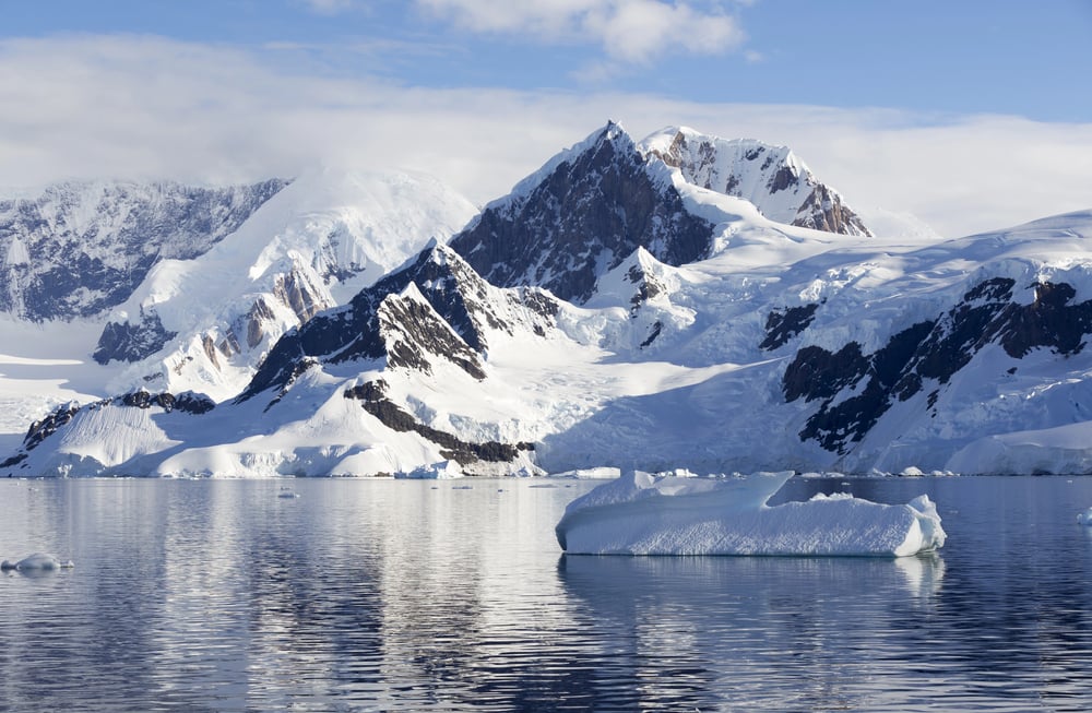
The bottom of the world produces some of the planet’s most consistent extreme winds. At Dumont d’Urville station in July 1972, Antarctica recorded winds of 199 mph.
These katabatic winds form when dense, cold air from the interior ice sheet flows downhill toward the coast, reaching speeds that can exceed 180 mph in coastal valleys. It’s like having a permanent hurricane made of frozen air.
Hurricane Camille’s Coastal Assault
Hurricane Camille produced some of the strongest hurricane winds ever to make a U.S. landfall, with sustained winds estimated at 175-190 mph when it hit Mississippi in 1969. The storm surge reached 24 feet in some areas, and the combination of wind and water completely erased entire communities from the map.
Camille’s eye was remarkably small and well-defined, concentrating its energy into a tight spiral of destruction.
Like Go2Tutors’s content? Follow us on MSN.
The Great New England Hurricane

The 1938 Long Island Express hurricane produced a 186 mph gust at Blue Hill Observatory in Massachusetts. This storm was remarkable because it maintained hurricane strength far inland, racing northward at 60 to 70 mph—about as fast as you’d drive on the highway.
The combination of the storm’s forward speed and its winds created a devastating one-two punch across New England.
Cyclone Tracy’s Christmas Devastation

On Christmas Eve 1974, Cyclone Tracy virtually wiped Darwin, Australia, off the map with winds exceeding 150 mph. The compact storm had an eye just 7 miles wide, concentrating its fury into a small but incredibly intense system.
Tracy destroyed over 70% of Darwin’s buildings and forced the evacuation of most of the city’s population.
Greenland’s Piteraq Winds

In Greenland, extreme katabatic winds called ‘piteraq’ can reach 180 mph when low pressure systems approach the coast. These winds form when cold, dense air from the massive Greenland ice sheet accelerates down steep coastal valleys.
The word ‘piteraq’ means ‘that which attacks you’ in the local language—a fitting name for winds powerful enough to flip boats and level buildings.
Like Go2Tutors’s content? Follow us on MSN.
Houston’s Derecho Destruction

In May 2024, a derecho hit Houston with 100 mph downburst winds that caused unexpected damage to the city’s downtown buildings. This straight-line wind event demonstrated how different types of extreme weather can impact structures in unique ways.
The derecho’s winds hit buildings horizontally with maximum force at ground level, shattering windows in hurricane-resistant skyscrapers and showing how meteorologists are still learning about the various ways powerful winds can cause destruction.
Canada’s Historic Derecho
The May 2022 Canadian derecho produced winds up to 190 km/h (118 mph) and traveled over 600 miles from Michigan to Quebec. This storm moved at nearly 60 mph, maintaining its strength across an unusually long distance.
It was described as one of the most impactful thunderstorms in Canadian history, killing 12 people and leaving over a million customers without power.
Santa Ana’s Fire Winds

California’s Santa Ana winds regularly exceed 100 mph in mountain passes and canyons. These hot, dry winds form when high pressure builds over the Great Basin, forcing air through Southern California’s mountain gaps.
The winds compress and heat up as they descend, creating the perfect conditions for explosive wildfire growth. Some of the state’s most devastating fires have been driven by Santa Ana winds reaching 80 to 100 mph.
Like Go2Tutors’s content? Follow us on MSN.
Nepal’s Devastating Downburst

On March 31, 2019, a powerful downburst cluster struck Nepal’s Bara and Parsa Districts with winds lasting 30-45 minutes, killing 28 people and injuring hundreds. This event demonstrated how thunderstorm winds can be just as deadly as tornadoes.
The downburst flattened buildings across a 21-mile by 28-mile area, showing how straight-line winds can affect much larger areas than rotating storms.
Commonwealth Bay’s Katabatic Chaos

Douglas Mawson, the famous Antarctic explorer, reported instantaneous wind speeds exceeding 168 mph at Cape Denison in Commonwealth Bay during his 1911-1914 expedition. Modern instruments deployed at the same location in 1995 recorded gusts exceeding 127 mph, confirming that this remote spot experiences some of Earth’s most consistent extreme winds.
The area has earned the nickname ‘Home of the Blizzard’ for good reason.
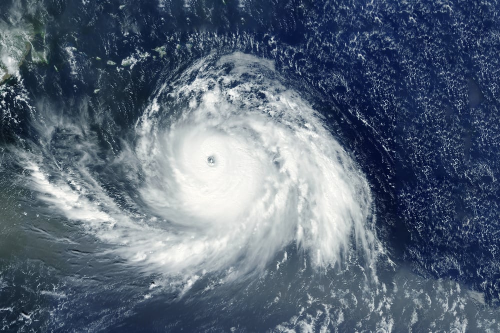
The Fujiwara Effect Winds

When two hurricanes get close enough, they begin to orbit each other in a phenomenon called the Fujiwara Effect. This rare interaction creates spectacular satellite imagery as the storms spiral around each other.
Hurricane Lester and Hurricane Madeline showcased this effect in 2016, with their interaction highlighting the Fujiwara Effect while both storms maintained major hurricane intensity with sustained winds over 150 mph.
Like Go2Tutors’s content? Follow us on MSN.
Nature’s Endless Power Source

Something amazing about the atmosphere of our planet is revealed by these wind records. Every extreme wind event serves as a metaphor for Earth’s atmospheric engine operating at full capacity, demonstrating the amazing forces that are always at work in our environment.
As we create better tools and modeling methods, the science underlying these phenomena keeps improving, enabling us to anticipate and get ready for nature’s most spectacular displays.
More from Go2Tutors!

- 16 Historical Figures Who Were Nothing Like You Think
- 12 Things Sold in the 80s That Are Now Illegal
- 15 VHS Tapes That Could Be Worth Thousands
- 17 Historical “What Ifs” That Would Have Changed Everything
- 18 TV Shows That Vanished Without a Finale
Like Go2Tutors’s content? Follow us on MSN.