20 Longest And Most Impressive Rivers
Rising from mountains, rivers carve paths before humans even arrive. These flows built early towns where food grew thick near banks.
Trade floated along them instead of marching across land. Settlements stuck close because survival tied tightly to currents.
Modern tools exist now yet countless lives link back to fresh water runs. Drinking begins there plus fields wait on each season’s flood.
Movement happens when boats follow steady streams. Water does more than move – it breathes through regions like veins under skin.
Length stretches beyond sight while depth hides secrets beneath ripples. Power surges during storms turning calm into roar.
Each great river acts less like a thing and more like weather – present, shifting, felt everywhere. Here are 20 of the longest and most impressive rivers on the planet, and what makes each one worth knowing about.
The Nile

Starting near Lake Victoria, the Nile runs roughly 4,130 miles across northeastern Africa – often called the planet’s longest river. Moving upward through eleven nations, it drains into the Mediterranean, odd because many southern rivers head opposite.
This waterway shaped nearly every part of ancient Egyptian life. Yearly flooding spread fertile black silt over fields, feeding agriculture for ages.
Civilizations lived close to its edges, their power rising and fading with the river’s rhythm.
The Amazon

Water from the Amazon River outpaces every other river, even if its length falls short. During high floods, its flow stretches far into the Atlantic, keeping saltwater at bay beyond one hundred miles out.
Moving slowly through Brazil, then cutting across Peru and touching Colombia, it travels close to four thousand miles. This river feeds off the biggest rainforest found anywhere above sea level.
One out of every five drops rolling over land worldwide comes from this single basin – a scale most people cannot truly picture.
The Yangtze
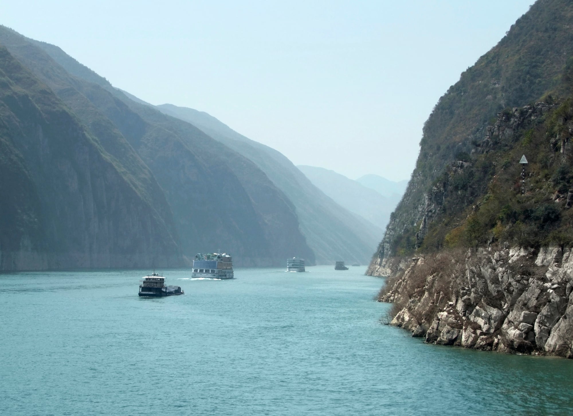
Stretching nearly 3,917 miles through China, the Yangtze winds from high on the Tibetan Plateau down toward the East China Sea – it holds the title of Asia’s longest river. For millennia, life along its banks has shaped Chinese society, while now it powers major parts of the global economy.
Standing in the middle of its flow, the Three Gorges Dam runs as the biggest hydroelectric plant ever made by humans. Across that vast drainage area, over 400 million souls call the Yangtze Basin home – a number larger than everyone living in the U.S.
The Mississippi
Starting in northern Minnesota, the Mississippi travels around 2,340 miles until it reaches the Gulf of Mexico, slicing through the heart of the U.S. When joined by the Missouri River – the longest feeder – it forms a network exceeding 3,700 miles, pulling water from three dozen states.
Long before America became a nation, people relied on this river for trade, movement, and survival. Heavy loads of silt move downstream constantly, letting fresh earth grow steadily at the mouth over millennia.
The Yenisei

Cold grips the ground where the Yenisei cuts through Siberia, carving a path nearly 3,445 miles long toward the Arctic Sea. This waterway ranks among Earth’s mightiest rivers, yet silence hangs heavy near its shores – few settlements dot the banks.
A vast stretch of Russia feeds into it, a drainage zone wider than Argentina’s full expanse. Winter locks the river under thick ice for many months at a time.
Come spring, thawing unleashes surging floods that reshape the landscape without warning. Harsh climate and isolation keep development sparse across most of the region.
Distance from major trade routes deepens its quiet existence. Size brings no crowds here – the opposite holds true.
The Yellow River

Twisting across northern China, the Yellow River stretches nearly 3,400 miles, hauling vast amounts of silt – this grit tints its waters a thick yellow. Because of that load, over millennia, rich soil piled high into flatlands perfect for growing crops.
Farming there began seven thousand years ago, planting deep roots for early Chinese society. Yet this life-giving flow turns dangerous often; floods have ripped through villages time after time.
To fight back, rulers long ago started stacking barriers along its edges. These man-made walls rise beside the current, holding back chaos with layers of earth and effort.
The Ob-Irtysh

Starting at the headwaters of the Irtysh, this sprawling waterway runs roughly 3,364 miles through Russia and Kazakhstan, ranking among Earth’s most extended river networks. Flowing northward, it gathers runoff from much of western Siberia before reaching a broad inlet of the Arctic Ocean – so expansive it resembles a landlocked sea.
As temperatures rise each spring, melting snow surges down while ice-choked stretches downstream struggle to keep up, triggering widespread flooding. Serving communities along its course, the system supplies essential freshwater to countless residents in both nations.
The Congo

The Congo River in central Africa is about 2,920 miles long and holds the distinction of being the deepest river in the world, with some sections reaching depths of over 720 feet. Its sheer depth is partly why it carries so much water downstream without spreading out as much as other large rivers do.
The Congo basin contains the second-largest tropical rainforest on Earth, right after the Amazon. The river crosses the equator twice during its journey, which is something almost no other major river does.
The Amur
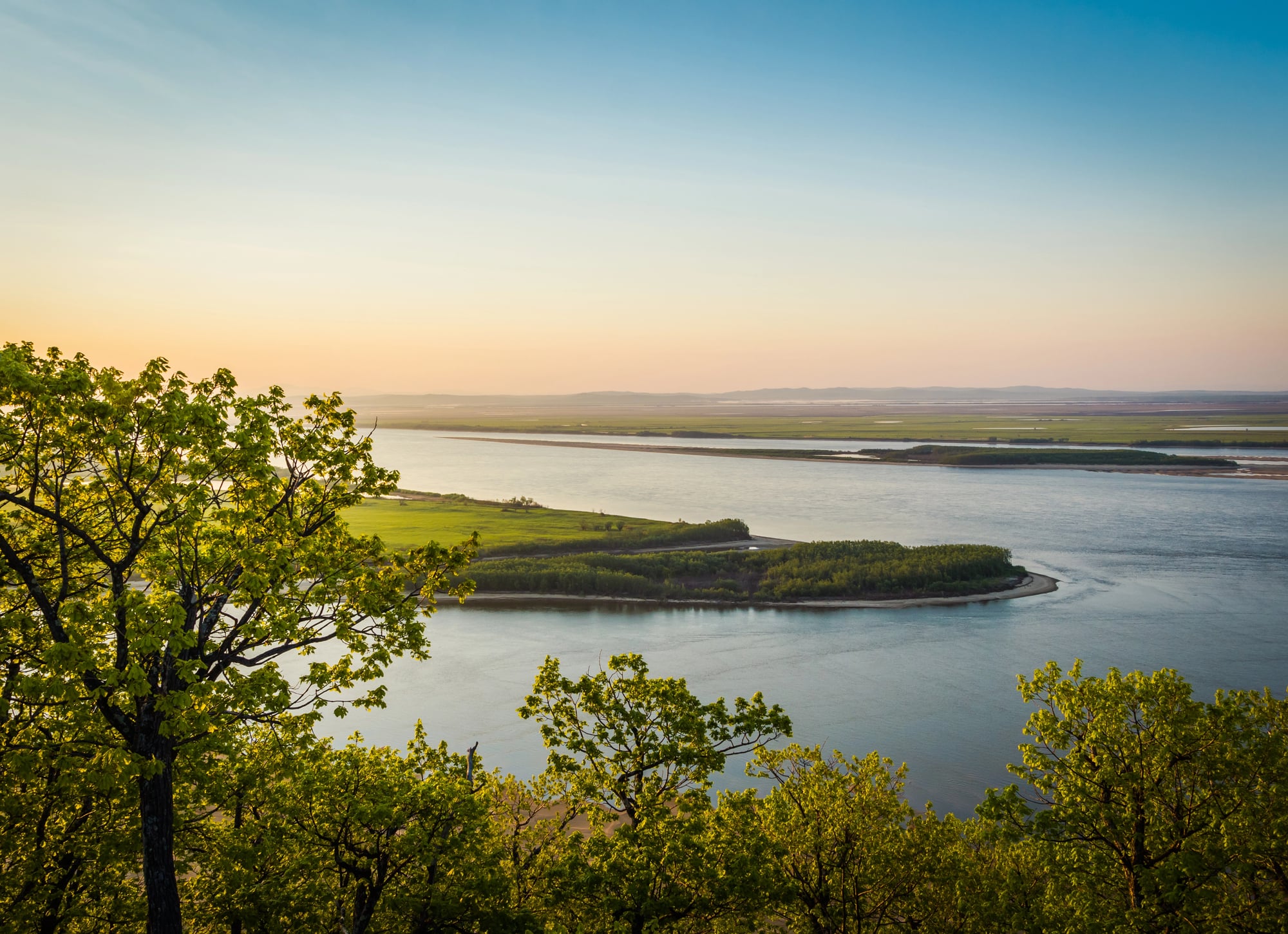
The Amur River forms a long stretch of the border between Russia and China, running about 2,763 miles before emptying into the Pacific Ocean. It is one of the few major rivers in the world that has largely avoided heavy industrial development, which has kept much of its ecosystem relatively intact.
The Amur is home to some rare species, including the Amur sturgeon, one of the largest freshwater fish in the world. Tensions between Russia and China over the river’s shared border have flared up at various points in history, making it as politically significant as it is ecologically important.
The Lena

Siberia’s Lena River stretches about 2,736 miles and is one of the largest rivers in the world by the volume of water it carries to the ocean. It flows entirely within Russia, cutting through some of the most isolated and least-populated land on Earth.
The Lena Pillars, a series of striking rock formations along its banks, earned UNESCO World Heritage status in 2012. In winter, the river freezes solid enough that trucks regularly drive across it as if it were a road.
The Mekong

The Mekong runs about 2,703 miles from the Tibetan Plateau through China, Myanmar, Laos, Thailand, Cambodia, and Vietnam before reaching the South China Sea. It passes through more countries than almost any other river in Asia, which makes it both a vital resource and a constant source of political tension.
The seasonal flooding of the Mekong creates one of the most productive freshwater fisheries in the world, feeding tens of millions of people. Cambodia’s Tonle Sap Lake, which actually reverses its flow direction twice a year depending on the Mekong’s water level, is one of the most unusual natural phenomena the river produces.
The Tocantins
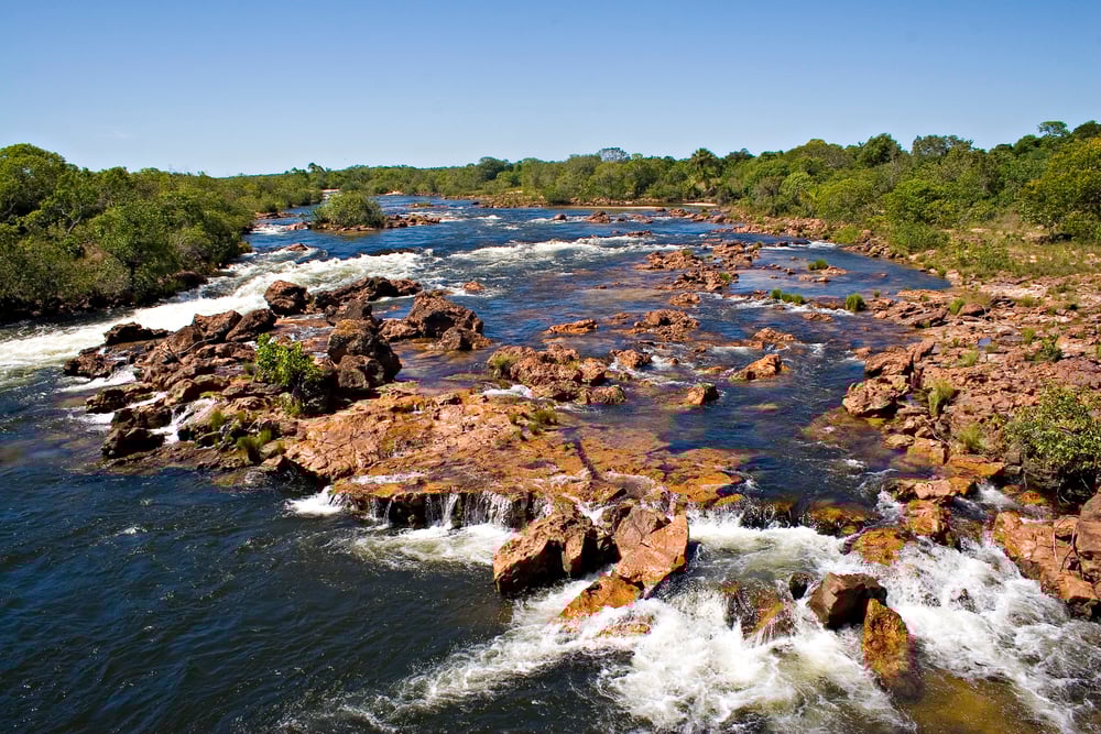
The Tocantins flows about 1,988 miles through central and northern Brazil before reaching the Atlantic Ocean. It is often grouped with the Amazon system, but it actually has its own independent outlet to the sea, which technically makes it a separate river system.
The Tucuruí Dam, built on the Tocantins, created one of the largest man-made lakes in the world and provides a huge portion of northern Brazil’s electricity. The river runs through a transitional zone between the Amazon rainforest and the cerrado, Brazil’s vast central grassland, giving it a unique mix of plant and animal life along its banks.
The Niger

The Niger River flows about 2,600 miles through western Africa, passing through Guinea, Mali, Niger, Benin, and Nigeria before emptying into the Gulf of Guinea. What makes it particularly unusual is its shape.
It curves sharply inland toward the Sahara Desert before looping back south toward the ocean, which is the opposite direction from what the geography would suggest. This inner delta region in Mali, called the Inland Niger Delta, floods seasonally to form a vast wetland that supports millions of farmers, herders, and fishermen.
Timbuktu, one of history’s most famous cities, sits near this river’s middle stretch.
The Murray-Darling
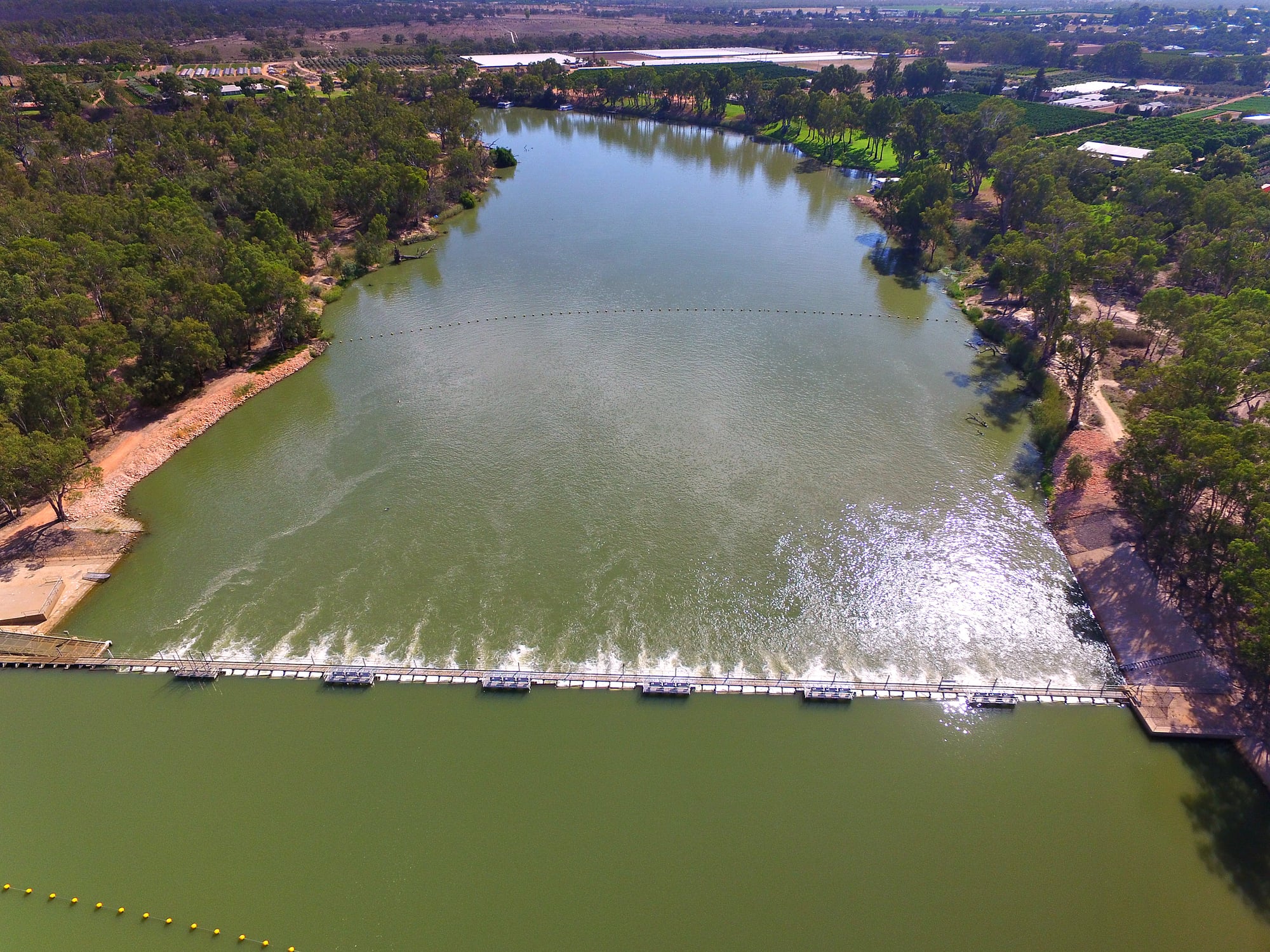
Australia’s Murray-Darling system stretches about 2,330 miles and is the country’s most important river network by far. It drains about 14 percent of the entire Australian continent and provides water to the country’s most productive agricultural region.
The system has faced serious stress from drought, overuse, and irrigation over the past century, and water management arguments between Australian states over the river remain heated to this day. The Murray River itself is the longest river in Australia and flows through some of the continent’s most scenic countryside.
The Volga

The Volga is Europe’s longest river, running about 2,294 miles across Russia before emptying into the Caspian Sea. It drains about 40 percent of European Russia and has been central to Russian culture, trade, and identity for centuries.
The river does not reach any ocean, which is unusual for a river of its size, because the Caspian Sea is landlocked. Russian literature, folk songs, and historical battles are so closely tied to the Volga that it is often called ‘Mother Volga’ by Russians, a name that reflects just how deeply the country feels connected to it.
The Indus

The Indus runs about 1,988 miles from Tibet through India and Pakistan before reaching the Arabian Sea. One of the world’s earliest and most advanced urban civilizations, the Indus Valley Civilization, grew up along its banks over 4,000 years ago.
The river is the backbone of Pakistan’s agriculture today, feeding an irrigation network that covers millions of acres of farmland. Water sharing between India and Pakistan over the Indus has been governed since 1960 by the Indus Waters Treaty, one of the few agreements between the two countries that has held firm through decades of conflict.
The Danube

The Danube flows about 1,777 miles across Europe, passing through or along the borders of 10 countries, more than any other river in the world. It begins in Germany’s Black Forest and ends at the Black Sea, collecting water from a basin that covers nearly half of continental Europe.
The river served as the northeastern frontier of the Roman Empire for centuries, and dozens of major cities including Vienna, Budapest, and Belgrade grew along its banks. Despite crossing so many political borders, the Danube remains one of Europe’s most navigable rivers and carries commercial traffic year-round.
The Zambezi

The Zambezi stretches about 1,600 miles across southern Africa and is best known as the river that feeds Victoria Falls, one of the largest waterfalls in the world. The falls drop about 354 feet, and the spray is visible from nearly 30 miles away on a clear day.
The river flows through six countries, Angola, Zambia, Namibia, Botswana, Zimbabwe, and Mozambique, before emptying into the Indian Ocean. The Kariba Dam on the Zambezi created Lake Kariba, which is one of the world’s largest man-made reservoirs by volume.
The Ganges

The Ganges flows about 1,569 miles through northern India and Bangladesh before reaching the Bay of Bengal. It is considered one of the most sacred rivers in Hinduism, and millions of people travel to its banks every year for religious ceremonies and rituals.
The river supports over 400 million people in terms of drinking water and agriculture, making it one of the most depended-upon rivers anywhere on Earth. Pollution and overuse have put serious pressure on the Ganges in recent decades, and India has launched multiple large-scale clean-up programs to address the damage.
The Colorado
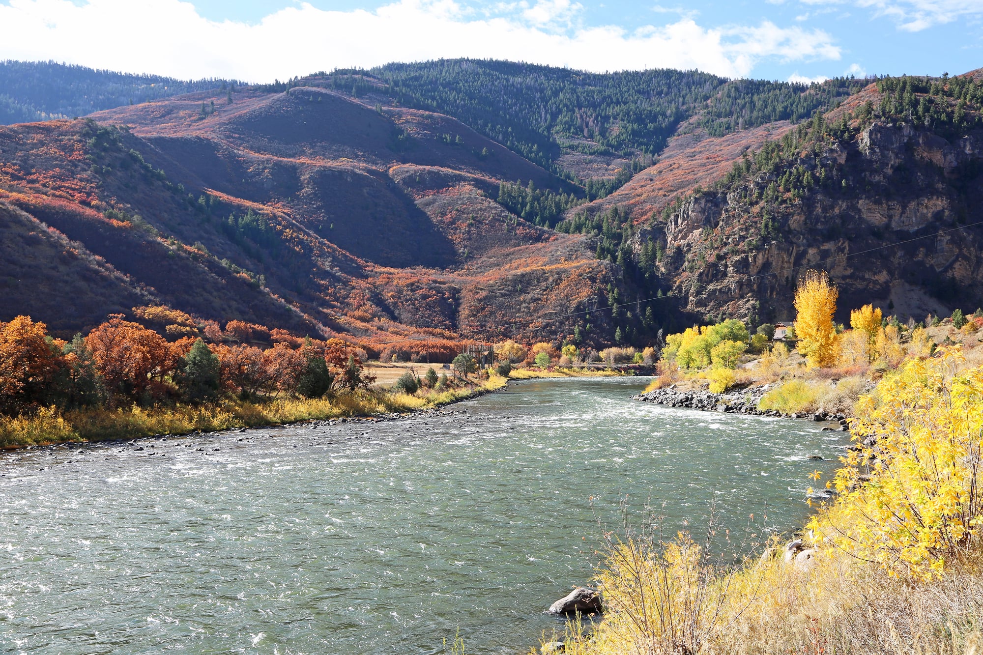
The Colorado River runs about 1,450 miles from the Rocky Mountains through the American Southwest before reaching the Gulf of California in Mexico. Over millions of years, it carved out the Grand Canyon, one of the most visited natural sites in the United States, cutting through rock layers that tell the geological story of the continent.
Heavy water use from farms, cities, and reservoirs has reduced the river so significantly that it rarely reaches the ocean anymore, running dry before it crosses the Mexican border. The Colorado is at the center of some of the most intense water rights battles in the American West, a fight that is only getting harder as the region gets drier.
The River Beneath Everything
Rivers were the original infrastructure of human civilization, and they remain the backbone of life on every continent today. From the Nile’s ancient flood plains to the Colorado’s shrinking flow, each of these rivers tells a story about the people who depended on it and the pressures those people created over time.
Many of the world’s longest rivers now face serious threats from climate change, pollution, and overuse, problems that no dam or treaty has fully solved. The rivers that fed the first cities are still flowing, and the choices made about them in the next few decades will determine whether future generations get to say the same thing.
More from Go2Tutors!

- The Romanov Crown Jewels and Their Tragic Fate
- 13 Historical Mysteries That Science Still Can’t Solve
- Famous Hoaxes That Fooled the World for Years
- 15 Child Stars with Tragic Adult Lives
- 16 Famous Jewelry Pieces in History
Like Go2Tutors’s content? Follow us on MSN