Early Maps Reshaped Worldviews
The world wasn’t always as well-known as it is today. Centuries ago, people had wildly different ideas about what existed beyond their own borders.
Early maps weren’t just tools for navigation. They were windows into how entire cultures understood the planet, and sometimes they got things spectacularly wrong.
These maps reflected fears, ambitions, religious beliefs, and sheer guesswork. When cartographers put ink to parchment, they weren’t just drawing lines.
They were defining reality for everyone who looked at their work. So let’s look at how these early attempts at mapping changed the way people saw the world.
Some discoveries were groundbreaking, while others were just plain bizarre.
The Babylonian clay tablet

One of the oldest maps ever found comes from ancient Babylon, carved into clay around 600 BCE. This map shows the world as a flat disk surrounded by water, with Babylon sitting right in the center.
The clay tablet depicts seven islands arranged in a circle beyond the known world, labeled with mysterious descriptions. Mountains, rivers, and neighboring regions appear as simple shapes.
For the Babylonians, this wasn’t just geography. It was a statement that their city was the most important place on Earth, and everything else radiated outward from there.
Ptolemy’s grid system

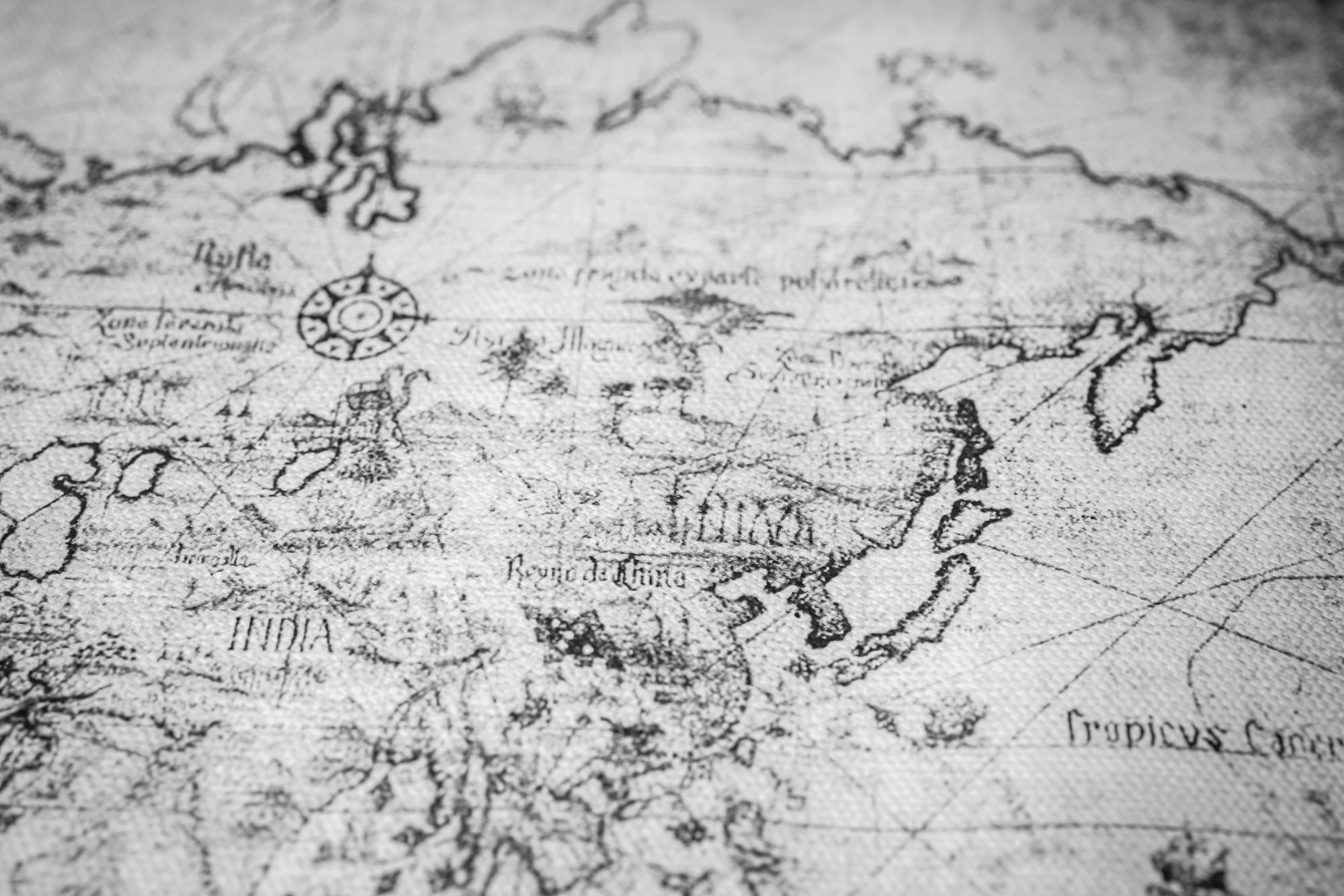
Claudius Ptolemy was a Greek geographer working in Roman Egypt around 150 CE, and his approach to mapping changed everything. He introduced latitude and longitude, creating a grid system that made it possible to pinpoint locations with some accuracy.
His maps covered the known world from the Atlantic to China, though many details were wildly off. Ptolemy’s work became the foundation for European cartography for over a thousand years.
His ideas spread through copies and translations, influencing explorers who would later sail into unknown waters with his coordinates in hand.
Monsters at the edge

Medieval European maps often featured terrifying creatures lurking at the boundaries of the known world. Sea serpents, dragons, and dog-headed men appeared regularly on maps from the 1200s to the 1500s.
Cartographers weren’t just being creative. They genuinely believed these beasts existed in unexplored regions.
The phrase ‘here be dragons’ captured the fear and fascination people felt about venturing too far from home. These illustrations warned sailors that danger awaited beyond familiar shores.
They reinforced the idea that the world had safe zones and forbidden ones.
The Tabula Rogeriana

In 1154, the Arab geographer Muhammad al-Idrisi created one of the most detailed maps of his time for King Roger II of Sicily. The Tabula Rogeriana depicted the world with south at the top, which was common in Islamic cartography.
It included accurate coastlines, mountain ranges, and trade routes across Europe, North Africa, and Asia. Al-Idrisi gathered information from travelers, merchants, and explorers for years before completing his work.
This map showed that knowledge about the world wasn’t confined to one culture or region. Different civilizations were building their own pictures of the planet, often with greater accuracy than their European counterparts.
Columbus and the shrinking Atlantic
Christopher Columbus believed the Atlantic Ocean was much smaller than it actually is, and this mistake came partly from reading maps wrong. Ptolemy had underestimated the size of the Earth, and Columbus took that miscalculation even further.
He thought Asia was just a few thousand miles west of Europe. This error gave him the confidence to sail west in 1492, expecting to reach the Indies quickly.
Instead, he stumbled onto the Americas. His misunderstanding of geography accidentally reshaped history, proving that sometimes being wrong can lead to massive discoveries.
Mercator’s distortion
Gerardus Mercator created his famous projection in 1569, and it became the standard for navigation. His map made it easy for sailors to plot straight-line courses, which was revolutionary for ocean travel.
But the Mercator projection has a major flaw. It makes landmasses near the poles look enormous compared to those near the equator.
Greenland appears almost as large as Africa, even though Africa is actually fourteen times bigger. This distortion influenced how people perceived the world for centuries, making northern regions seem more important than they really were.
The invention of America

When German cartographer Martin Waldseemüller published his world map in 1507, he did something that stuck forever. He labeled the newly discovered landmass ‘America’ after the explorer Amerigo Vespucci.
Vespucci had written letters describing his voyages to the New World, and Waldseemüller believed he deserved the credit for recognizing it as a separate continent. Columbus never got that honor, even though he arrived first.
Waldseemüller’s map was printed in a thousand copies and spread across Europe. The name America became permanent, all because one mapmaker made a decision about what to write on his creation.
China at the center

Chinese maps from the Ming Dynasty placed China at the center of everything, just like the Babylonians did with their own city. Maps from the 1400s showed China as a vast empire surrounded by smaller, less important kingdoms.
Chinese cartographers had detailed knowledge of their own territory, including rivers, roads, and administrative boundaries. But they showed less interest in distant lands.
This worldview reflected Chinese culture at the time, which saw itself as the Middle Kingdom, the most advanced civilization on Earth. Maps reinforced that belief by making everything else look peripheral.
The search for Terra Australis

For centuries, European cartographers included a giant southern continent on their maps, even though nobody had seen it. This imaginary landmass, called Terra Australis, was thought to balance the weight of the continents in the Northern Hemisphere.
Mapmakers drew it stretching across the entire bottom of the globe. Explorers spent decades searching for this mythical land.
When Captain James Cook finally sailed into the southern Pacific in the 1770s, he found Australia and Antarctica, but they were much smaller than expected. The old maps had created a fantasy that shaped exploration for generations.
Venice and trade routes

Medieval maps from Venice focused heavily on trade routes because the city was a commercial powerhouse. Venetian cartographers drew detailed portolan charts showing coastlines, ports, and sailing directions across the Mediterranean and Black Seas.
These maps were practical tools for merchants and sailors, not grand statements about the world. They featured rhumb lines radiating from compass roses, making navigation easier.
Venetian maps reflected the city’s priorities: money, trade, and safe passage. They were less concerned with the interior of continents and more focused on where ships could dock and goods could be exchanged.
Indigenous mapping traditions

Native peoples across the Americas, Australia, and the Pacific had their own mapping traditions long before Europeans arrived. These maps often appeared on bark, animal skins, or were drawn in sand.
They showed hunting grounds, water sources, sacred sites, and seasonal migration routes. Indigenous maps focused on relationships between places rather than strict geographic accuracy.
For example, Aboriginal Australians created songlines, which were oral maps encoded in stories and songs. These traditions proved that mapping wasn’t just a European invention.
Different cultures developed their own ways of understanding and representing space.
The flat Earth myth

Contrary to popular belief, educated people in medieval Europe knew the Earth was round. Ancient Greek scholars had proven it, and that knowledge never completely disappeared.
However, some early maps still depicted a flat Earth because they were simplifying complex ideas or following religious conventions. The myth that medieval people universally believed in a flat Earth didn’t become widespread until the 1800s, when it was used to mock earlier generations.
Maps from the Middle Ages often showed a circular world, but that didn’t always mean they thought it was literally flat. Cartography and belief systems were more complicated than modern stereotypes suggest.
Japan’s isolation

Japanese maps from the Edo period reflected the country’s strict isolation policy, which lasted from the 1600s to the mid-1800s. Mapmakers produced detailed charts of Japan itself but showed the outside world in vague, often inaccurate terms.
Foreign lands appeared distorted or incomplete because Japan had limited contact with them. This isolation shaped how Japanese people understood their place in the world.
When American ships arrived in 1853 and forced Japan to open its borders, the sudden influx of Western maps shocked the population. They realized their view of the world had been deliberately limited.
The Northwest Passage obsession

European maps from the 1500s and 1600s often showed a convenient water route through North America connecting the Atlantic and Pacific Oceans. This imaginary Northwest Passage appeared on map after map, even though nobody had found it.
Explorers spent decades searching for this shortcut, driven by maps that promised it existed. The passage became a cartographic fantasy that cost lives and resources.
It wasn’t until the 1900s that ships finally navigated through the Arctic using modern technology. The early maps had created false hope, showing how much power cartographers had to shape exploration.
African interior mysteries

European maps of Africa from the 1700s and early 1800s had detailed coastlines but left the interior mostly blank or filled with speculation. Cartographers wrote phrases like ‘unexplored regions’ across vast areas.
Some maps showed imaginary rivers, mountains, or kingdoms that didn’t exist. This reflected Europe’s limited knowledge of the continent, even as they established coastal trading posts.
The blank spaces on African maps fueled racist assumptions that the continent lacked civilization or history. When explorers finally traveled inland, they found complex societies and cities that had been there all along.
The maps hadn’t shown reality. They’d shown European ignorance.
Polynesian stick charts
Polynesian navigators created stick charts from coconut fibers and shells to represent ocean swells, currents, and island locations across the Pacific. These maps weren’t meant to be taken on voyages.
They were teaching tools used to train navigators in reading the ocean itself. Each chart encoded generations of knowledge about wave patterns and how they changed near land.
Polynesian sailors could navigate thousands of miles without instruments, using only their understanding of the sea. Their stick charts prove that mapping doesn’t require paper or ink.
It requires deep observation and a connection to the environment.
The age of standardization

By the 1800s, cartography became more scientific and standardized. Governments funded detailed surveys, and new printing techniques made maps widely available.
The British Ordnance Survey and similar projects in other countries created maps based on precise measurements rather than guesswork. This shift changed how people related to maps.
They became documents of authority rather than personal interpretations. The mystery and imagination that filled earlier maps disappeared, replaced by accuracy and utility.
Maps stopped being stories and became data.
How we see the world now
Modern technology like satellites and GPS has made mapping almost perfect, but the way maps are designed still shapes how people think. Different projections emphasize different parts of the world, and no flat map can show a round planet without some distortion.
Online maps center on wherever the user is located, creating a personalized geography that would have amazed early cartographers. Despite all the advances, maps still reflect the biases and priorities of the people who make them.
They’re never just neutral representations of space. They’re arguments about what matters and what doesn’t, just like they’ve always been.
More from Go2Tutors!

- The Romanov Crown Jewels and Their Tragic Fate
- 13 Historical Mysteries That Science Still Can’t Solve
- Famous Hoaxes That Fooled the World for Years
- 15 Child Stars with Tragic Adult Lives
- 16 Famous Jewelry Pieces in History
Like Go2Tutors’s content? Follow us on MSN.