Largest Glaciers Outside Polar Zones
Ice dominates the polar regions, but some of the planet’s most impressive glaciers exist far from the poles. These massive rivers of ice carve through mountain ranges, feed rivers that sustain millions of people, and create landscapes that defy easy description.
The largest non-polar glaciers concentrate in a few key regions where altitude and climate conditions align perfectly to sustain these frozen giants.
Southern Patagonian Ice Field: The Giant of South America
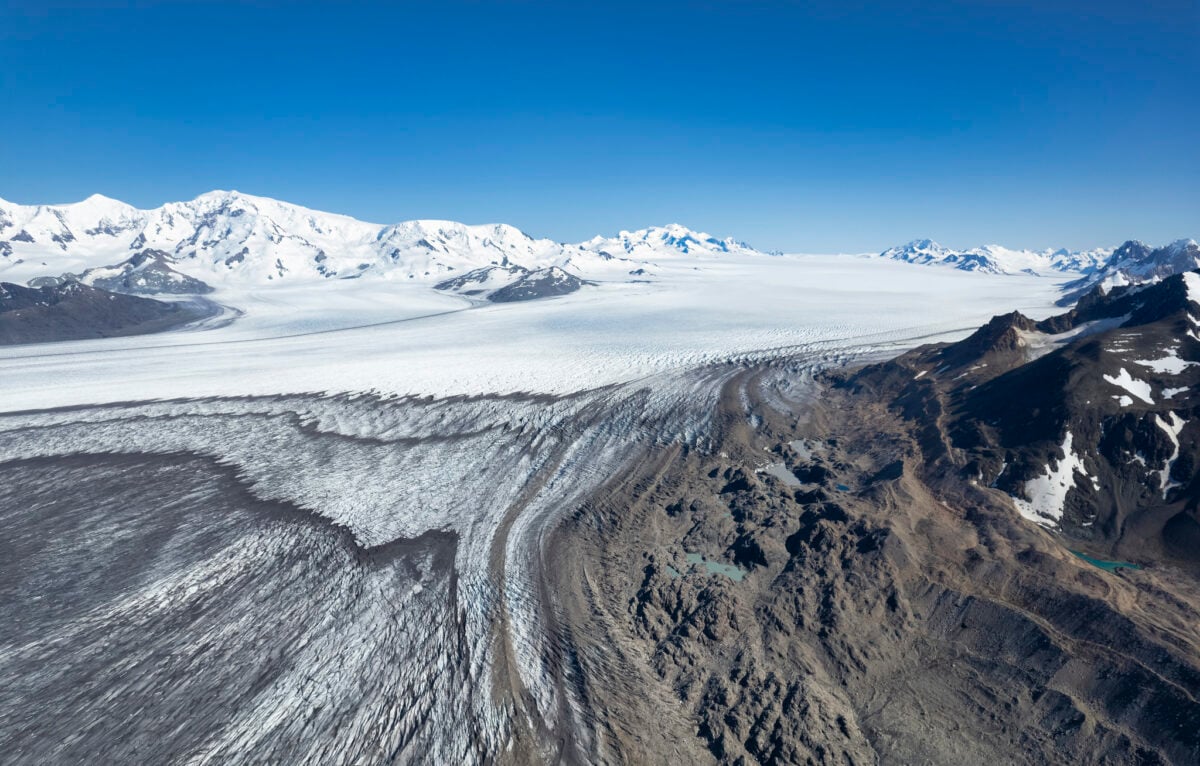
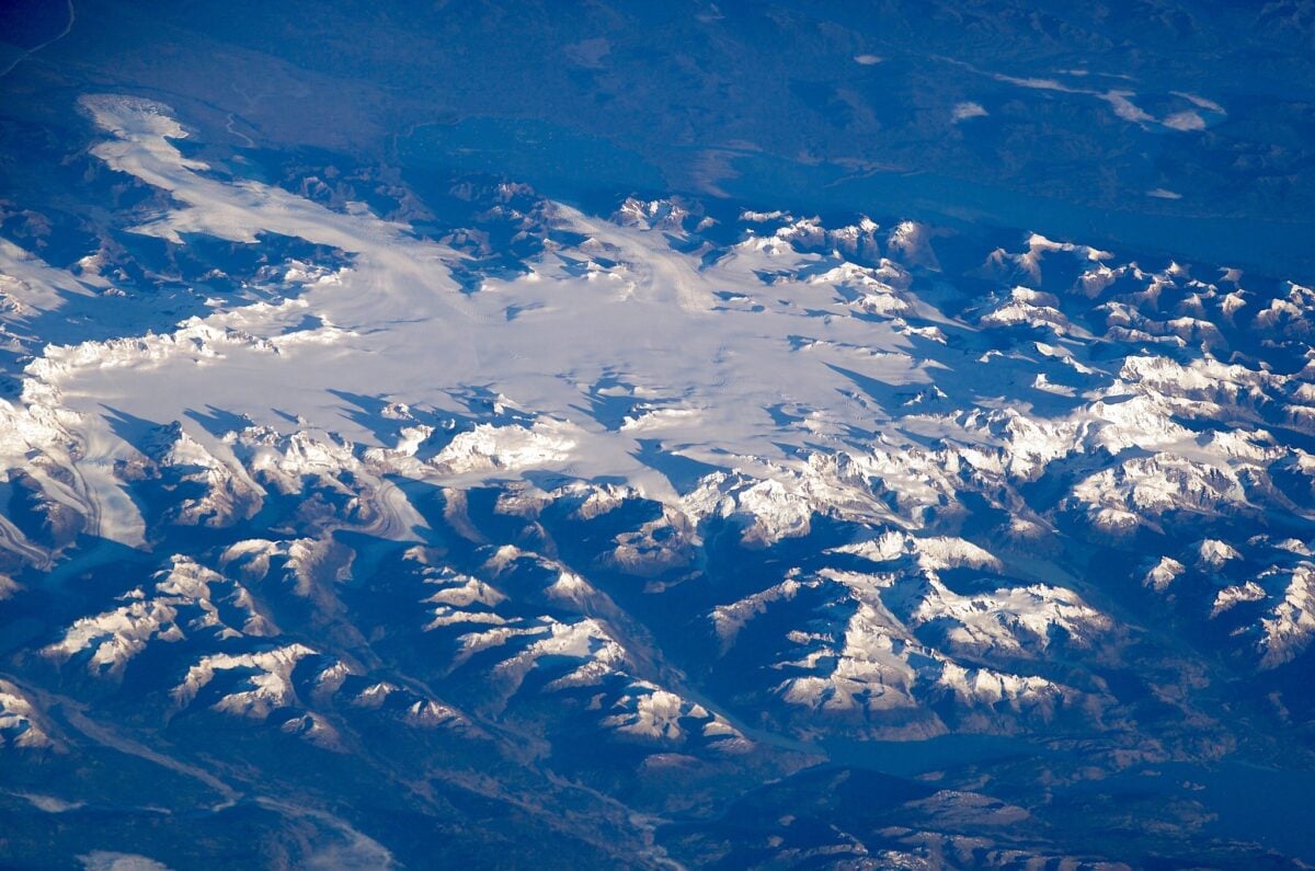
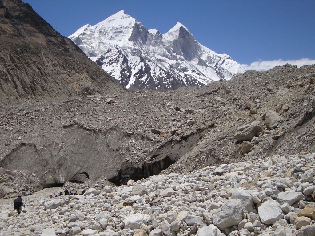
The Southern Patagonian Ice Field stretches across 350 kilometers of the Andes Mountains between Chile and Argentina. Covering roughly 13,000 square kilometers, it ranks as the second largest contiguous ice mass outside polar regions.
More than 60 outlet glaciers flow from this massive ice field, carving valleys and feeding into both Pacific fjords and massive freshwater lakes. Precipitation drives the ice field’s survival.
The western flank receives up to four meters of rain and snow annually, while the eastern side gets less than a meter. This creates dramatically different landscapes on either side of the mountain range.
Dense rainforests thrive on the wet western slopes, while the eastern plains remain relatively dry and barren. The ice field hosts some of the fastest moving glaciers on Earth.
Jorge Montt Glacier flows north at speeds reaching several kilometers per year, while smaller glaciers advance at more modest rates. Scientists track these movements closely because the Patagonian ice fields contribute about ten percent of global sea level rise from all glaciers and ice caps worldwide.
Fedchenko Glacier: The Longest Outside the Poles
Tajikistan’s Fedchenko Glacier snakes 77 kilometers through the Pamir Mountains. The glacier ranks as the longest non-polar glacier on Earth and reaches a maximum thickness of 1,000 meters in places.
From its origins at 6,200 meters elevation, it drops 2,500 meters as it flows northward before melting into the Balandkiik River. Russian explorer Alexei Pavlovich Fedchenko lent his name to the glacier, though he never actually discovered it.
A German-Soviet expedition fully explored the glacier in 1928, mapping its length and documenting its tributaries. Dozens of smaller glaciers feed into Fedchenko, creating a complex system of ice rivers.
The glacier feeds the Muksu, Vakhsh, and Amu Darya rivers. These waterways eventually reach the Aral Sea some 2,000 kilometers away.
Nearly 90 percent of Central Asia’s population depends on water from the Pamir Mountains for drinking, agriculture, and energy production. The glacier has shrunk by 1,400 meters since 1933, but increased precipitation in recent decades may help stabilize it.
Siachen Glacier: The Battlefield on Ice

Siachen Glacier in the Karakoram Mountains extends 76 kilometers, making it the second longest non-polar glacier. The glacier sits on the Line of Control between India and Pakistan, and both countries maintain military outposts on its frozen expanse.
Soldiers stationed here face temperatures that plummet to minus 58 degrees Fahrenheit. The glacier covers 270 square miles including all its tributary glaciers.
It flows through the Nubra Valley, a highly glacierized region where ice covers roughly two-thirds of the total basin area. The glacier produces copious meltwater during summer months, feeding the Nubra River system.
Military conflict has left its mark on Siachen. Supplies reach outposts by helicopter, and avalanches claim lives regularly.
The environmental impact of maintaining military presence on the glacier concerns scientists who study the region’s glacial recession patterns.
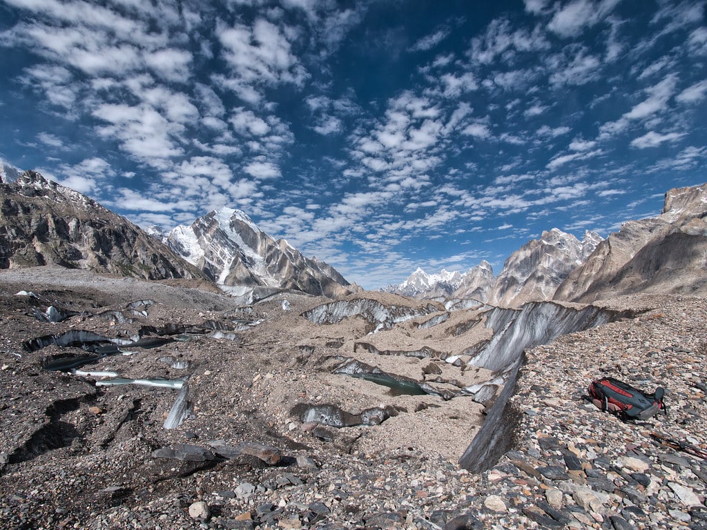
Biafo-Hispar Glacier System: The Frozen Highway

The Biafo Glacier in Pakistan’s Karakoram Mountains stretches 67 kilometers before meeting the 49-kilometer Hispar Glacier at Hispar La, an elevation of 5,128 meters. Together they form a 120-kilometer glacial system that connects two ancient mountain kingdoms.
The system represents the longest continuous non-polar glacier pathway on Earth. Trekkers who cross this route face days of boulder hopping across unstable moraine.
The journey from Askole village in Braldo takes experienced hikers about a week to complete. Snow Lake near the high point of the trek ranks as one of the largest accumulations of snow and ice outside polar regions.
The Biafo Glacier alone covers a basin area of 853 square kilometers, with 628 square kilometers characterized by permanent snow and ice. The accumulation zone contributes 68 percent of the glacier’s total area, ensuring its survival despite climate pressures.
Baltoro Glacier: Gateway to Giants
Baltoro Glacier flows 39 miles through the Gilgit-Baltistan region of Pakistan. The glacier serves as the base camp approach route for K2, the world’s second highest mountain.
Four of the world’s 14 peaks over 8,000 meters surround the Baltoro, making it one of the most spectacular glacial settings on Earth. The glacier feeds the Shigar River, which eventually flows into the Indus River system.
During summer melt, the river carries massive quantities of sediment downstream, creating distinctive grey water visible for kilometers. The glacial flour suspended in the water comes from rocks ground beneath the glacier’s immense weight.
Mountaineering expeditions use the Baltoro as their highway to the high peaks. Porters carry supplies up the glacier for weeks at a time, establishing camps that support climbing attempts.
The glacier surface presents constant challenges with crevasses, ice towers called seracs, and rapidly changing weather conditions.
Brüggen Glacier: Southern Hemisphere Champion
Chile’s Brüggen Glacier, also called Pío XI Glacier, stretches 41 miles through southern Patagonia. The glacier holds the distinction of being the longest in the Southern Hemisphere outside Antarctica.
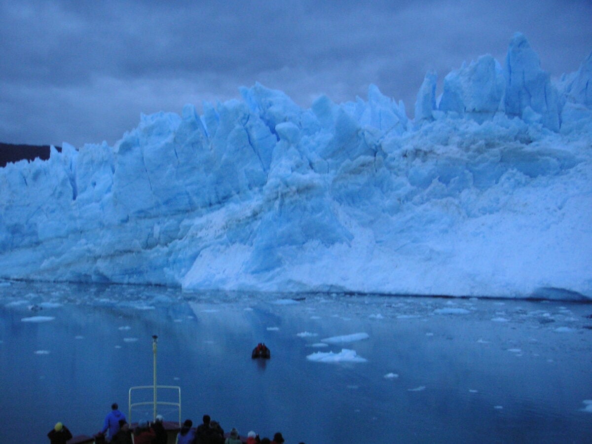
It covers 488 square miles and has actually advanced by 3.1 miles between 1945 and 1976, bucking the global trend of glacial retreat. The glacier flows from the Southern Patagonian Ice Field into Pacific fjords, creating dramatic calving displays when massive ice chunks break free.
Unlike most glaciers worldwide, Brüggen shows signs of stability and even growth in recent decades. Scientists study it intensely to understand what factors allow some glaciers to resist retreat while others shrink rapidly.
A thick debris layer on the glacier’s terminus may protect it from excessive melting. This debris insulates the ice beneath, reducing melt rates compared to clean ice exposed directly to air and sunlight.
Northern Patagonian Ice Field: The Smaller Sibling
The Northern Patagonian Ice Field covers approximately 4,000 square kilometers, making it considerably smaller than its southern counterpart but still massive by non-polar standards. The ice field sits entirely within Chile and feeds numerous outlet glaciers that flow west into Pacific fjords.
San Rafael Glacier ranks as the most accessible glacier in the Northern Ice Field. Boats carry tourists from Puerto Chacabuco to witness the glacier’s blue face and watch ice calve into the lagoon.
The glacier has retreated significantly in recent decades, losing about half its length over 30 years. Climate conditions at the Northern Ice Field mirror those farther south, with extremely high precipitation on western slopes and drier conditions to the east.
The ice field has lost about 103 cubic kilometers of ice since the end of the Little Ice Age around 1870.
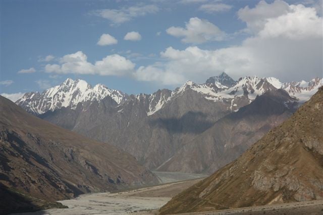
South Inylchek Glacier: Central Asia’s Giant
The South Inylchek Glacier extends 38 miles through the Central Tian Shan Mountains across Kyrgyzstan and China. The glacier moves faster than most in Central Asia, creating Lake Merzbacher through its seasonal damming of meltwater.
When this ice dam fails periodically, it releases catastrophic floods downstream. The North and South Inylchek Glaciers form two arms of a larger glacial system.
The uppermost portions cross international boundaries, with segments in Kazakhstan and China as well as the main mass in Kyrgyzstan. Together they form one of Asia’s most significant glacial reserves.
Mountain peaks surrounding the glacier exceed 7,000 meters elevation, including Khan Tengri at 7,010 meters. These heights ensure consistent snowfall that feeds the glacier’s accumulation zone, though warming temperatures threaten the balance between accumulation and melting.
Batura Glacier: The Karakoram’s Beauty
Batura Glacier flows 35 miles through the Gojal region of Gilgit-Baltistan in Pakistan. The glacier supports a surprising amount of vegetation in the valleys below it, and villages sit remarkably close to its terminus.
Local people depend on glacial meltwater for irrigation and drinking water. The glacier creates spectacular scenery with massive ice walls rising from valley floors.
Wildlife including snow leopards, ibex, and Himalayan brown bears inhabit the surrounding mountains. These animals adapt to the harsh conditions and depend on the ecosystem created by glacial processes.
Road access makes Batura more approachable than many Karakoram glaciers. The Karakoram Highway passes nearby, allowing travelers to view the glacier without extended trekking.
Local communities have developed tourism infrastructure around the glacier.
Perito Moreno Glacier: The Tourist Favorite
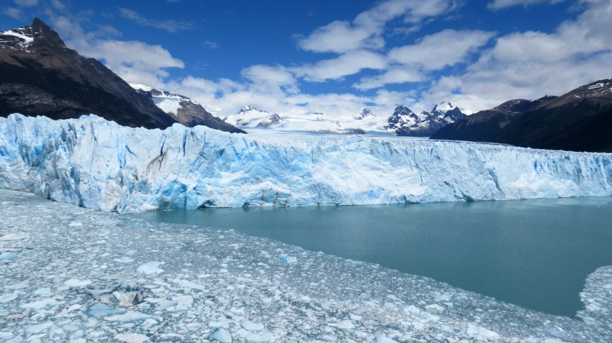
Argentina’s Perito Moreno Glacier extends from the Southern Patagonian Ice Field into Lake Argentino. The glacier covers 258 square kilometers and ranks among the few glaciers worldwide that remains relatively stable.
Its terminus advances and retreats in a rough balance, creating dramatic rupture events every few years. The glacier regularly dams off a section of Lake Argentino, causing water levels to rise until pressure breaks through the ice.
These rupture events attract thousands of visitors who watch massive sections of ice collapse into the lake. The thunderous sounds and waves created by these events echo across the valley.
Wooden walkways allow visitors to approach within a few hundred meters of the glacier’s face. This accessibility has made Perito Moreno one of the most visited glaciers on Earth.
Its blue ice walls rising 70 meters above the lake surface create stunning photographs.
Gangotri Glacier: Sacred Ice of India
The Gangotri Glacier in Uttarakhand, India, stretches through the Himalayas near the border with China. The glacier holds immense religious significance as the source of the Ganges River at its terminus point called Gomukh.
Pilgrims trek to Gomukh to bathe in the sacred waters emerging from beneath the ice. The glacier extends about 30 kilometers and has retreated significantly over the past century.
Scientists monitor it closely because millions of people downstream depend on the Ganges for water supply. The glacier feeds one of the world’s largest river systems by discharge volume.
High altitude and consistent Himalayan snowfall maintain the glacier despite regional warming trends. The accumulation zone sits above 5,000 meters where temperatures remain cold enough to preserve ice year-round.
Summer melt creates substantial river flow that peaks during the monsoon season.
Jostedalsbreen: Europe’s Frozen Crown
Norway’s Jostedalsbreen Glacier covers 487 square kilometers, making it the largest glacier on mainland Europe. The ice cap sits atop a mountain plateau, with numerous outlet glaciers descending into surrounding valleys.
Over 50 outlet arms flow from the main ice mass, each with its own characteristics. The glacier receives enormous precipitation from Atlantic storm systems that dump snow throughout winter months.
This consistent snowfall offsets summer melting, though the glacier has retreated overall since the end of the Little Ice Age. The ice reaches thicknesses exceeding 600 meters in places.
Tourist infrastructure allows easy access to several outlet glaciers. Guided walks on the ice attract thousands of visitors annually.
The glacier’s surface shows dramatic features including crevasses, ice caves, and moulins where meltwater plunges into the glacier’s interior.
Vatnajökull: Iceland’s Massive Cap
Iceland’s Vatnajökull Glacier covers between 8,100 and 8,300 square kilometers, making it the largest glacier in Europe overall. The ice cap sits atop active volcanic systems that occasionally erupt beneath the ice, creating spectacular jökulhlaups when meltwater escapes in catastrophic floods.
The glacier reaches ice thicknesses of 1,000 meters and contains about 3,100 cubic kilometers of ice by volume. Multiple outlet glaciers flow from the ice cap in all directions, creating diverse landscapes around its margins.
Some outlets advance into the sea while others terminate in proglacial lakes or valleys. Volcanic heat beneath certain sections of the glacier creates subglacial lakes and unique ecosystems.
Scientists study these environments as potential analogs for ice-covered moons elsewhere in the solar system. The combination of ice and volcanic activity makes Vatnajökull a natural laboratory for understanding glacial-volcanic interactions.
Where Ice Meets Future
Though huge, the biggest non-polar glaciers are fragile in their own way. Depending on where they sit, warming hits them in unique ways – yet most keep shrinking.
A number shed tens of meters of ice every year; others, luckier ones, hold steady or creep forward just a bit. Ice covers act like giant storage tanks where they’re found.
As melting picks up speed, the runoff feeds rivers that sustain huge populations. Predicting just how fast things might change remains difficult work.
Researchers keep logging depth shifts, watching movement rates, and studying patterns affecting future supplies. What unfolds now could alter life far beyond glaciers’ edges.
More from Go2Tutors!

- The Romanov Crown Jewels and Their Tragic Fate
- 13 Historical Mysteries That Science Still Can’t Solve
- Famous Hoaxes That Fooled the World for Years
- 15 Child Stars with Tragic Adult Lives
- 16 Famous Jewelry Pieces in History
Like Go2Tutors’s content? Follow us on MSN.